Plik:Claremont square, Islington (4) - geograph.org.uk - 1523975.jpg
Claremont_square,_Islington_(4)_-_geograph.org.uk_-_1523975.jpg (640 × 433 pikseli, rozmiar pliku: 120 KB, typ MIME: image/jpeg)
| Plik Claremont square, Islington (4) - geograph.org.uk - 1523975.jpg znajduje się w Wikimedia Commons – repozytorium wolnych zasobów. Dane z jego strony opisu znajdują się poniżej. |
_-_geograph.org.uk_-_1523975.jpg)
Opis
| Opis |
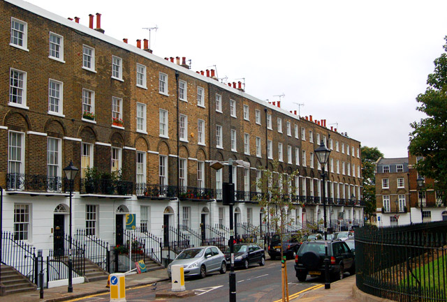
English: Claremont square, Islington (4) Looking southwest at the south side of Claremont Square, Islington. The square was developed in the 1820s around the Upper Pond of the New River Company.
The New River is a man-made water channel which carried drinking water for 20 miles to London from the River Lee and Amwell Springs in Hertfordshire. It opened in 1613 and fed reservoirs in Islington. One of these, known as the Upper Pond, was built in 1709 beside Pentonville Road. The reservoir in Claremont Square was covered and turfed in 1852 when open areas of standing water in London were prohibited by law. The reservoir is still in use by Thames Water. The semi-improved grassland on the top and sides of the reservoir supports a wide diversity of wild flowers and is a preserved habitat with restricted access. In this photo, the bank of the reservoir is just visible on the right of the picture. See also [1] and [2] . |
| Data | |
| Źródło | From geograph.org.uk |
| Autor | Andy F |
| Uznanie autorstwa (wymagana przez licencję) | Andy F / Claremont square, Islington (4) / |
| Pozycja fotografa | | To i inne zdjęcia na: OpenStreetMap |
|---|
_-_geograph.org.uk_-_1523975.jpg¶ms=051.531240_N_-000.109000_E_globe:Earth_type:camera_source:geograph-osgb36(TQ31268306)_heading:225.00&language=pl)
| Pozycja obiektu | | To i inne zdjęcia na: OpenStreetMap |
|---|
_-_geograph.org.uk_-_1523975.jpg¶ms=051.531070_N_-000.109600_E_globe:Earth_class:object_type:object_source:geograph-osgb36(TQ31228304)_heading:225.00&language=pl)
Licencja

|
Ta grafika pochodzi z kolekcji projektu Geograph. Aby zobaczyć szczegóły możesz odwiedzić stronę tego zdjęcia w serwisie Geograph. Prawa autorskie do tej grafiki posiada Andy F i jest ona udostępniona na licencji Creative Commons Uznanie autorstwa – Na tych samych warunkach 2.0.
|
- Wolno:
- dzielić się – kopiować, rozpowszechniać, odtwarzać i wykonywać utwór
- modyfikować – tworzyć utwory zależne
- Na następujących warunkach:
- uznanie autorstwa – musisz określić autorstwo utworu, podać link do licencji, a także wskazać czy utwór został zmieniony. Możesz to zrobić w każdy rozsądny sposób, o ile nie będzie to sugerować, że licencjodawca popiera Ciebie lub Twoje użycie utworu.
- na tych samych warunkach – Jeśli zmienia się lub przekształca niniejszy utwór, lub tworzy inny na jego podstawie, można rozpowszechniać powstały w ten sposób nowy utwór tylko na podstawie tej samej lub podobnej licencji.
Historia pliku
Kliknij na datę/czas, aby zobaczyć, jak plik wyglądał w tym czasie.
| Data i czas | Miniatura | Wymiary | Użytkownik | Opis | |
|---|---|---|---|---|---|
| aktualny | 04:53, 3 mar 2011 | | 640 × 433 (120 KB) | GeographBot | == {{int:filedesc}} == {{Information |description={{en|1=Claremont square, Islington (4) Looking southwest at the south side of Claremont Square, Islington. The square was developed in the 1820s around the Upper Pond of the New River Company. The New R |
Lokalne wykorzystanie pliku
Poniższa strona korzysta z tego pliku:
Globalne wykorzystanie pliku
Ten plik jest wykorzystywany także w innych projektach wiki:
- Wykorzystanie na ar.wikipedia.org
- Wykorzystanie na arz.wikipedia.org
- Wykorzystanie na de.wikipedia.org
- Wykorzystanie na fr.wikipedia.org
- Wykorzystanie na ja.wikipedia.org
- Wykorzystanie na www.wikidata.org
_-_geograph.org.uk_-_1523975.jpg)