Plik:Ebola Outbreak Map (ongoing).png

Rozmiar pierwotny (2454 × 1502 pikseli, rozmiar pliku: 841 KB, typ MIME: image/png)
| Plik Ebola Outbreak Map (ongoing).png znajduje się w Wikimedia Commons – repozytorium wolnych zasobów. Dane z jego strony opisu znajdują się poniżej. |
.png)

|
This file may be updated to reflect new information. If you wish to use a specific version of the file without new updates being mirrored, please upload the required version as a separate file. |
Opis
| Opis |
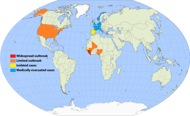
English: Continuation of the moribund map located at https://commons.wikimedia.org/wiki/File:Map_of_Ebola_Outbreak_-_1_October_2014.svg |
| Data | |
| Źródło | Praca własna |
| Autor | Раціональне анархіст |
I've undertaken to update an older map, and to simplify the previous cluttered color scheme by removing recorded deaths versus none (a fiddly distinction which required excessive updating). Since a November 20 Wikimedia security rule change, it is apparently no longer possible to upload the .svg scalable format. This file is a 150% .png enlargement of the .svg working document carried over from the previous source.
Suggested rules for updating:
- BLUE: Medically evacuated cases: Any area in which an Ebola case from elsewhere has been treated. Blue regions do not become another color unless there's an actual local outbreak (either due to it escaping the evac facility, or arriving from another source). An ex-blue color cannot become blue again unless it achieves green first (42-day limit passage), then another evac case arrives.
- YELLOW: Isolated cases: Anywhere Ebola is "loose", but for which all or nearly all known and suspected cases are in treatment or quarantine.
- ORANGE: Limited outbreak: An arbitrarily moderate number of persons are infected, including unknown infected "spreaders", but the medical infrastructure is not overwhelmed.
- RED: Widespread outbreak: An out-of-control situation overwhelming available medical infrastructure. Many unidentified infected "spreaders".
Progression: YELLOW > ORANGE > RED > ORANGE > YELLOW.
Please refrain from updating this file if you are not in possession of a master .svg file, and posting a master-derived image in the same format and dimensions as the preceding imagery.
Licencja

|
Udziela się zgody na kopiowanie, rozpowszechnianie oraz modyfikowanie tego dokumentu zgodnie z warunkami GNU Licencji Wolnej Dokumentacji, w wersji 1.2 lub nowszej opublikowanej przez Free Software Foundation; bez niezmiennych sekcji, bez treści umieszczonych na frontowej lub tylnej stronie okładki. Kopia licencji załączona jest w sekcji zatytułowanej GNU Licencja Wolnej Dokumentacji. |
- Wolno:
- dzielić się – kopiować, rozpowszechniać, odtwarzać i wykonywać utwór
- modyfikować – tworzyć utwory zależne
- Na następujących warunkach:
- uznanie autorstwa – musisz określić autorstwo utworu, podać link do licencji, a także wskazać czy utwór został zmieniony. Możesz to zrobić w każdy rozsądny sposób, o ile nie będzie to sugerować, że licencjodawca popiera Ciebie lub Twoje użycie utworu.
- na tych samych warunkach – Jeśli zmienia się lub przekształca niniejszy utwór, lub tworzy inny na jego podstawie, można rozpowszechniać powstały w ten sposób nowy utwór tylko na podstawie tej samej lub podobnej licencji.
Historia pliku
Kliknij na datę/czas, aby zobaczyć, jak plik wyglądał w tym czasie.
.png&dir=prev)
.png&offset=20150807001640)
.png&offset=&limit=20)
.png&offset=&limit=50)
.png&offset=&limit=100)
.png&offset=&limit=250)
.png&offset=&limit=500)
| Data i czas | Miniatura | Wymiary | Użytkownik | Opis | |
|---|---|---|---|---|---|
| aktualny | 01:33, 17 wrz 2017 | | 2454 × 1502 (841 KB) | Jamie Tubers | According to the discussion had on the article talkpage: https://en.wikipedia.org/wiki/Talk:West_African_Ebola_virus_epidemic/Archive_8#July_2016_map_in_Epidemiology:_Outbreak_section |
| 05:00, 9 kwi 2017 |  | 2454 × 1502 (854 KB) | Agricolae | recolor to reflect historical perspective rather than current situation (after outbreak is over everywhere) | |
| 15:16, 14 wrz 2016 |  | 2454 × 1502 (861 KB) | Heitordp | Surveillance period ended in all countries | |
| 13:12, 3 kwi 2016 |  | 2454 × 1502 (880 KB) | The Anome | Isolated outbreaks in both Guinea and Liberia | |
| 01:14, 1 kwi 2016 |  | 2454 × 1502 (861 KB) | Heitordp | Sierra Leone free, new cases in Guinea | |
| 00:05, 8 lut 2016 |  | 2454 × 1502 (826 KB) | Heitordp | Liberia free again, isolated cases in Sierra Leone | |
| 15:58, 29 gru 2015 |  | 2454 × 1502 (885 KB) | The Anome | Guinea now Ebola-free as of 29 December 2015, Liberia only with yellow status now | |
| 03:10, 22 lis 2015 |  | 2454 × 1502 (826 KB) | Heitordp | Sierra Leone free, new case in Liberia | |
| 09:04, 5 wrz 2015 |  | 2454 × 1502 (824 KB) | Раціональне анархіст | Liberia clear again. | |
| 02:16, 7 sie 2015 |  | 2454 × 1502 (824 KB) | Раціональне анархіст | Sierra Leone and Guinea improved to yellow after neither country has had more than five new cases per week for two reporting cycles. |
Lokalne wykorzystanie pliku
Poniższa strona korzysta z tego pliku:
Globalne wykorzystanie pliku
Ten plik jest wykorzystywany także w innych projektach wiki:
- Wykorzystanie na ca.wikipedia.org
- Wykorzystanie na en.wikipedia.org
- Wykorzystanie na en.wikiversity.org
- Wykorzystanie na fi.wikipedia.org
- Wykorzystanie na fr.wikinews.org
- Wykorzystanie na hu.wikipedia.org
- Wykorzystanie na ja.wikipedia.org
- Wykorzystanie na ko.wikipedia.org
- Wykorzystanie na no.wikipedia.org
- Wykorzystanie na ro.wikipedia.org
- Wykorzystanie na ru.wikipedia.org
- Wykorzystanie na rw.wikipedia.org
- Wykorzystanie na uk.wikipedia.org
- Wykorzystanie na www.wikidata.org
.png)