Plik:ElectoralCollege1892.svg

Rozmiar pierwotny (Plik SVG, nominalnie 1020 × 593 pikseli, rozmiar pliku: 108 KB)
| Plik ElectoralCollege1892.svg znajduje się w Wikimedia Commons – repozytorium wolnych zasobów. Dane z jego strony opisu znajdują się poniżej. |
| U.S. presidential election maps (SVG) |
| See also: National Atlas maps (png) |
|
1789 · 1792 · 1796 · 1800 · 1804 · 1808 · 1812 · 1816 · 1820 · 1824 · 1828 · 1832 · 1836 · 1840 · 1844 · 1848 · 1852 · 1856 · 1860 · 1864 · 1868 · 1872 · 1876 · 1880 · 1884 · 1888 · 1892 · 1896 · 1900 · 1904 · 1908 · 1912 · 1916 · 1920 · 1924 · 1928 · 1932 · 1936 · 1940 · 1944 · 1948 · 1952 · 1956 · 1960 · 1964 · 1968 · 1972 · 1976 · 1980 · 1984 · 1988 · 1992 · 1996 · 2000 · 2004 · 2008 · 2012 · 2016 · 2020 · 2024 |
Opis
| Opis | |
| Data | (Original); 2009-10-10 (Current) |
| Źródło | This image was adapted from File:ElectoralCollege1964.svg (itself based off File:Blank_US_Map.svg) using data from Cherokee Heritage Center Historical Maps, the original version uploaded by AndyHogan14 and the National Atlas of the United States |
| Autor |
Cg-realms (current) AndyHogan14 (original) |
| Inne wersje | File:1892_Electoral_Map.png |
Licencja
| Ja, właściciel praw autorskich do tej pracy, udostępniam ją jako własność publiczną. Dotyczy to całego świata. W niektórych krajach może nie być to prawnie możliwe, jeśli tak, to: Zapewniam każdemu prawo do użycia tej pracy w dowolnym celu, bez żadnych ograniczeń, chyba że te ograniczenia są wymagane przez prawo. |
SVG Support
This document is in the Scalable Vector Graphic format (SVG) and requires a supported browser (Opera 9, Firefox 2+) or a SVG plugin for Internet Explorer and other browsers. SVG is an open source format, which means this map can be downloaded and modified/translated completely using a vector graphics editor like Adobe Illustrator or Inkscape (free) or a text editor such as Notepad.
| BLANK THUMBNAIL | View large PNG | View medium PNG | SVG Plugin for Internet Explorer and other browsers |
|---|---|---|---|
| Click here (purge cache) and then CTRL+F5 to reload. Help? | Try 1 Try 2 | Try 1 Try 2 | Adobe SVG plugin |
| Recommended browser | More Help | ||
| Opera 9.1 | List of SVG tools |
Historia pliku
Kliknij na datę/czas, aby zobaczyć, jak plik wyglądał w tym czasie.
| Data i czas | Miniatura | Wymiary | Użytkownik | Opis | |
|---|---|---|---|---|---|
| aktualny | 04:25, 27 gru 2016 | | 1020 × 593 (108 KB) | Wow | Harrison |
| 05:30, 8 lis 2016 |  | 1020 × 593 (108 KB) | Wow | Territories | |
| 09:44, 7 lis 2016 |  | 1020 × 593 (116 KB) | Wow | recoloring | |
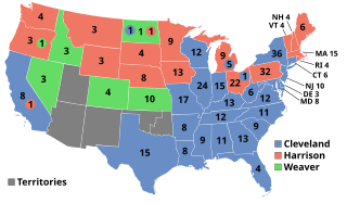
| 01:41, 14 lis 2013 |  | 1020 × 593 (211 KB) | Ariostos | Weaver carried North Dakota on a Populist-Democratic Fusion ticket, not Cleveland. | |
| 06:36, 11 paź 2009 |  | 1020 × 593 (128 KB) | Cg-realms | The District of Columbia was not yet entitled to electors. | |
| 22:31, 10 paź 2009 |  | 1020 × 593 (129 KB) | Cg-realms | Texas was incorrectly marked as Republican | |
| 21:29, 10 paź 2009 |  | 1020 × 593 (129 KB) | Cg-realms | North Dakota color issue | |
| 21:25, 10 paź 2009 |  | 1020 × 593 (129 KB) | Cg-realms | I was 90 percent of the way there last time; this one should finally fix it | |
| 21:15, 10 paź 2009 |  | 1020 × 593 (127 KB) | Cg-realms | A last ditch effort to correct problem that only effects low resolution downsamples. | |
| 21:06, 10 paź 2009 |  | 1020 × 593 (126 KB) | Cg-realms | Yet another attempt to solve English Wikipedia electoral circle bug |
Lokalne wykorzystanie pliku
Poniższa strona korzysta z tego pliku:
Globalne wykorzystanie pliku
Ten plik jest wykorzystywany także w innych projektach wiki:
- Wykorzystanie na da.wikipedia.org
- Wykorzystanie na de.wikipedia.org
- Wykorzystanie na el.wikipedia.org
- Wykorzystanie na en.wikipedia.org
- Grover Cleveland
- 1892 United States presidential election
- People's Party (United States)
- User talk:Cg-realms
- Electoral vote changes between United States presidential elections
- List of United States presidential election results by state
- Presidency of Benjamin Harrison
- 1892 United States presidential election in California
- United States presidential election
- Wikipedia talk:WikiProject Maps/Archive 2009
- 1892 United States presidential election in Pennsylvania
- 1892 United States presidential election in Montana
- Wikipedia:Reference desk/Archives/Humanities/2012 November 19
- Template:1892 United States presidential election imagemap
- Template:State results of the 1892 U.S. presidential election
- 1892 United States presidential election in New York
- 1892 United States elections
- 1892 United States presidential election in Kansas
- 1892 United States presidential election in Virginia
- 1892 United States presidential election in Wisconsin
- Presidencies of Grover Cleveland
- User:Orser67/Harrison
- 1892 United States presidential election in Vermont
- 1892 United States presidential election in New Hampshire
- 1892 United States presidential election in Massachusetts
- 1892 United States presidential election in Connecticut
- 1892 United States presidential election in Maine
- 1892 United States presidential election in Rhode Island
- 1892 United States presidential election in New Jersey
- 1892 United States presidential election in South Carolina
- 1892 United States presidential election in Washington (state)
- 1892 United States presidential election in Ohio
- 1892 United States presidential election in Wyoming
- 1892 United States presidential election in Georgia
- 1892 United States presidential election in Idaho
- 1892 United States presidential election in Nevada
- 1892 United States presidential election in North Dakota
- 1892 United States presidential election in Colorado
- 1892 United States presidential election in Oregon
- 1892 United States presidential election in South Dakota
- 1892 United States presidential election in Nebraska
- 1892 United States presidential election in Texas
- 1892 United States presidential election in Minnesota
- 1892 United States presidential election in Michigan
Pokaż listę globalnego wykorzystania tego pliku.