Plik:Floristic regions in Europe (english).png

Rozmiar podglądu – 751 × 600 pikseli. Inne rozdzielczości: 301 × 240 pikseli | 601 × 480 pikseli | 962 × 768 pikseli | 1280 × 1022 pikseli | 1797 × 1435 pikseli.
Rozmiar pierwotny (1797 × 1435 pikseli, rozmiar pliku: 1,95 MB, typ MIME: image/png)
| Plik Floristic regions in Europe (english).png znajduje się w Wikimedia Commons – repozytorium wolnych zasobów. Dane z jego strony opisu znajdują się poniżej. |
.png)
Opis
| Opis |
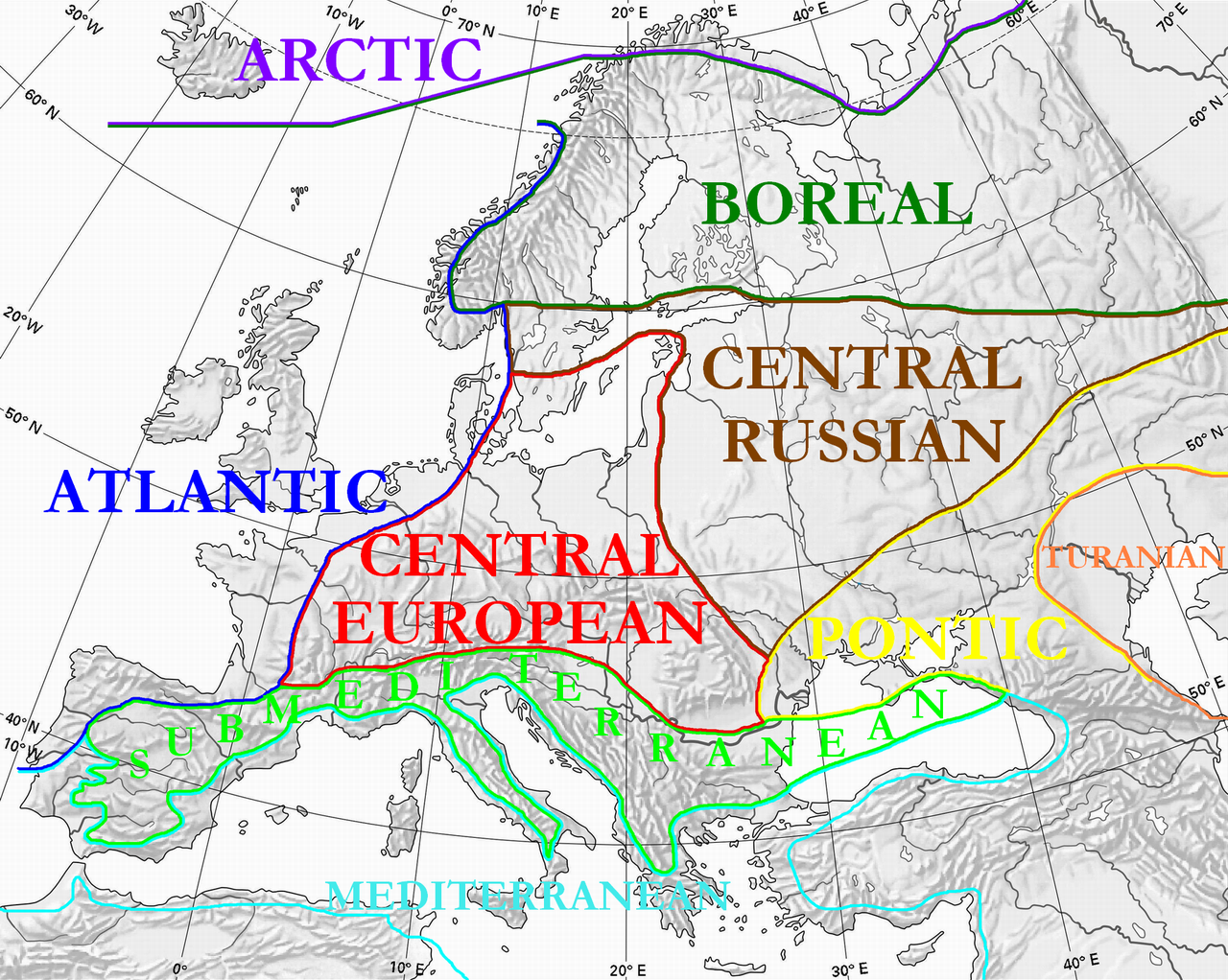
English: Floristic regions in Europe and western Siberia, according to Wolfgang Frey and Rainer Lösch
Français : Régions floristiques européennes actuelles (Europe et Siberie occidentale), selon Wolfgang Frey et Rainer Lösch |
| Data | |
| Źródło | Praca własna |
| Autor | User:Olahus |
| Inne wersje | Prace pochodne od tego pliku: Floristic regions in Europe-de.png |

|
Ta grafika (biogeographical map) (lub wszystkie grafiki w tym artykule bądź kategorii) powinny zostać przetworzone na grafiki wektorowe jako plik SVG. O zaletach grafik wektorowych można przeczytać na stronie Commons:Media for cleanup. Jeśli wersja SVG tej grafiki jest już dostępna, załaduj ją. Po załadowaniu SVG zamień ten szablon na stronie tej grafiki na szablon {{vector version available|nazwa nowej grafiki.svg}}.
|
Licencja
| Ja, właściciel praw autorskich do tej pracy, udostępniam ją jako własność publiczną. Dotyczy to całego świata. W niektórych krajach może nie być to prawnie możliwe, jeśli tak, to: Zapewniam każdemu prawo do użycia tej pracy w dowolnym celu, bez żadnych ograniczeń, chyba że te ograniczenia są wymagane przez prawo. |
Historia pliku
Kliknij na datę/czas, aby zobaczyć, jak plik wyglądał w tym czasie.
| Data i czas | Miniatura | Wymiary | Użytkownik | Opis | |
|---|---|---|---|---|---|
| aktualny | 02:36, 3 lip 2010 | | 1797 × 1435 (1,95 MB) | Ras67 | cropped |
| 00:15, 29 mar 2008 |  | 1800 × 1442 (2,17 MB) | Olahus | {{Information |Description=Floristic regions in Europe and western Siberia, according to Wolfgang Frey and Rainer Lösch |Source=own work |Date=2008 |Author= Olahus |Permission= |other_versions= }} |
Lokalne wykorzystanie pliku
Poniższa strona korzysta z tego pliku:
Globalne wykorzystanie pliku
Ten plik jest wykorzystywany także w innych projektach wiki:
- Wykorzystanie na ar.wikipedia.org
- Wykorzystanie na bn.wikipedia.org
- Wykorzystanie na br.wikipedia.org
- Wykorzystanie na bs.wikipedia.org
- Wykorzystanie na ca.wikipedia.org
- Wykorzystanie na cs.wikipedia.org
- Wykorzystanie na el.wikipedia.org
- Wykorzystanie na en.wikipedia.org
- Wykorzystanie na eo.wikipedia.org
- Wykorzystanie na es.wikipedia.org
- Wykorzystanie na fa.wikipedia.org
- Wykorzystanie na fi.wikipedia.org
- Wykorzystanie na frp.wikipedia.org
- Wykorzystanie na fr.wikipedia.org
- Wykorzystanie na gl.wikipedia.org
- Wykorzystanie na hi.wikipedia.org
- Wykorzystanie na hu.wikipedia.org
- Wykorzystanie na hy.wikipedia.org
- Wykorzystanie na it.wikipedia.org
- Wykorzystanie na ja.wikipedia.org
- Wykorzystanie na kk.wikipedia.org
- Wykorzystanie na ko.wikipedia.org
Pokaż listę globalnego wykorzystania tego pliku.
.png)
.png)