Plik:NE 600ad.jpg
Rozmiar pierwotny (1439 × 1086 pikseli, rozmiar pliku: 1,14 MB, typ MIME: image/jpeg)
| Plik NE 600ad.jpg znajduje się w Wikimedia Commons – repozytorium wolnych zasobów. Dane z jego strony opisu znajdują się poniżej. |
Opis
| Opis |
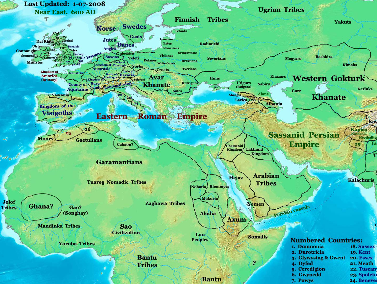
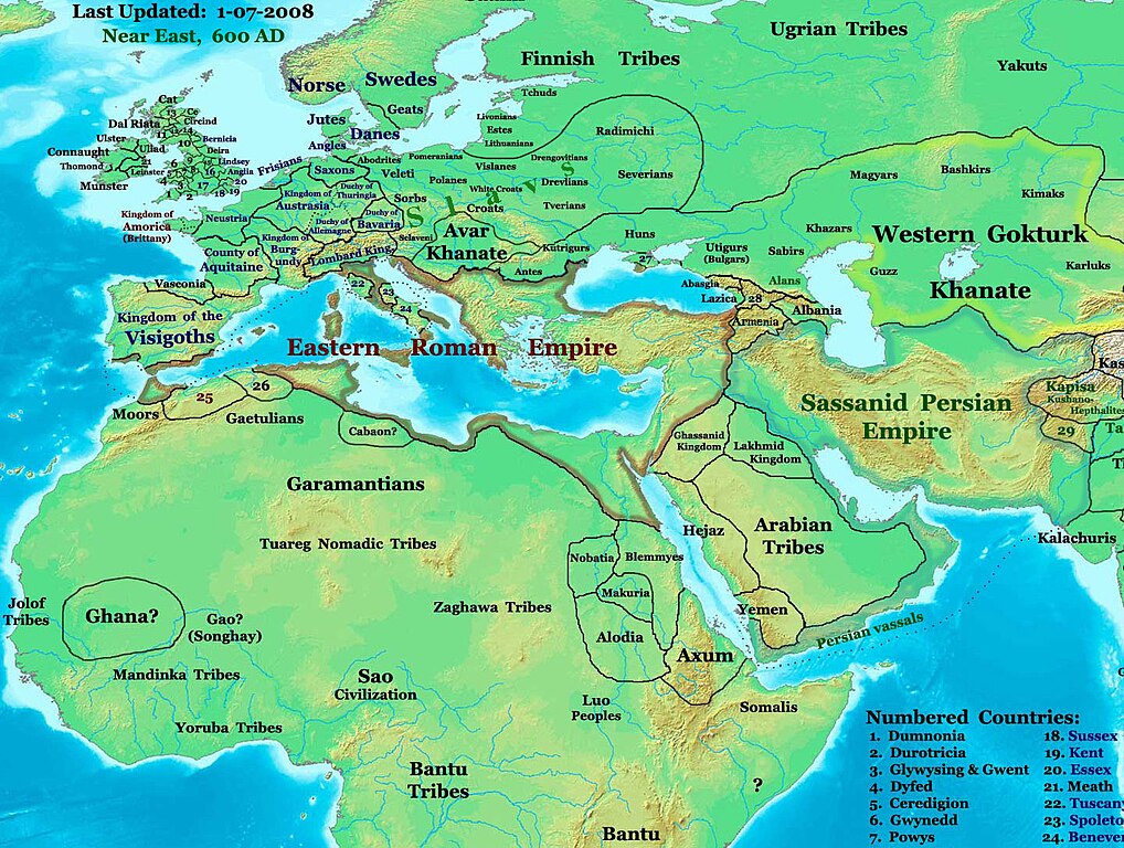
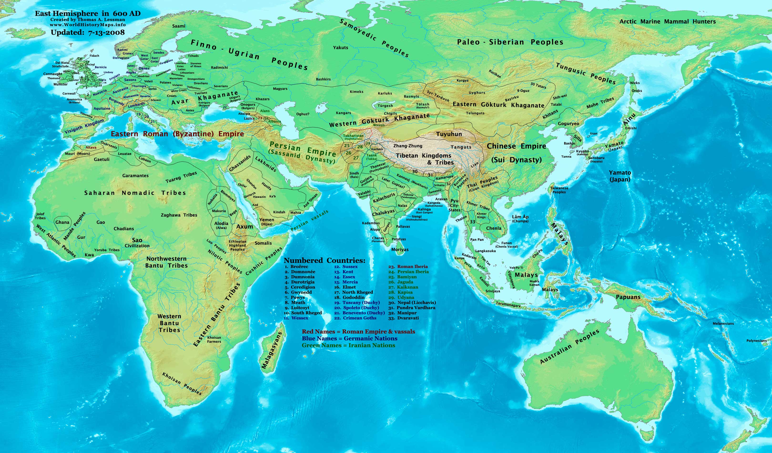
English: part of: Eastern Hemisphere in 600 AD.
Description: This image is a zoomed-in version of the Eastern Hemisphere in 600 AD. Author: Thomas A. Lessman (talessman@yis.us), later modified by others. Source URL: http://www.worldhistorymaps.info/images/East-Hem_600ad.jpg. Image Summary:Created by Thomas Lessman, based on this map of Eastern Hemisphere in 600 AD. Free for educational use. If you use this image, please credit the author (Thomas Lessman) and include (Source URL: http://www.worldhistorymaps.info/images/East-Hem_600ad.jpg). If you can help improve this map, please contact Thomas Lessman at talessman@yis.us. Other Historical Maps by Thomas Lessman
|
|||||||||||||||||||||||||
| Data | 17 stycznia 2008 (data pierwszego przesłania pliku) | |||||||||||||||||||||||||
| Źródło | Na Commons przeniesiono z en.wikipedia. | |||||||||||||||||||||||||
| Autor | Talessman z angielskiej Wikipedii | |||||||||||||||||||||||||
| Licencja (Ponowne użycie tego pliku) |
|
|||||||||||||||||||||||||
| Inne wersje | Disputed map because the version with « Romanised Dacians » (= Olahok, Vlachs) and « Slavs » (Totok, Slavons, Slovens...) may be a romanian and slavic POV, but this « Only Avars and no other people north of the Danube, in the future Kingdom of Hungary », according to the Eduard Rössler's « Awarenwüste » theory, shows an Austrian-Hungarian POV: one is not more objective than the other and unfortunately no synthesis is possible. | |||||||||||||||||||||||||
Licencja

|
Udziela się zgody na kopiowanie, rozpowszechnianie oraz modyfikowanie tego dokumentu zgodnie z warunkami GNU Licencji Wolnej Dokumentacji, w wersji 1.2 lub nowszej opublikowanej przez Free Software Foundation; bez niezmiennych sekcji, bez treści umieszczonych na frontowej lub tylnej stronie okładki. Kopia licencji załączona jest w sekcji zatytułowanej GNU Licencja Wolnej Dokumentacji. |
| Ten plik udostępniony jest na licencji Creative Commons Uznanie autorstwa – Na tych samych warunkach 3.0. | ||
| Uznanie autorstwa: Talessman at the English Wikipedia | ||
| ||
| Ten szablon został dodany jako element zmiany licencjonowania. |
| Maps of the eastern hemisphere showing history
Bold dates are available on Wikimedia or Wikipedia. | ||
| Primeval | ||
| Ancient
|
·| 600 BC | 550 BC | 527 BC | 500 BC |
400 BC | ·| 1 AD | 50 AD | 100 AD | 200 AD | 300 AD | | |
| Medieval |
·| 500 AD | 565 AD | 600 AD | 700 AD | | |
| Modern |
·| 1500 AD | · * For historical maps of the whole world, | |
·
Oryginalny rejestr przesyłania
- 2008-01-17 20:07 Talessman 1439×1086× (513542 bytes) Added more info for Africa, corrected some info on Europe.
- 2007-11-02 18:55 Talessman 1450×988× (440135 bytes) Corrected borders in Africa/Sudan and Arabia.
- 2007-10-31 20:30 Talessman 1429×927× (437106 bytes) Corrected borders of Ghana, made other names easier to read, other misc. corrections.
- 2007-10-21 00:19 Talessman 1251×779× (341469 bytes) Author: Thomas A. Lessman. Source URL: http://www.ThomasLessman.com/History/images/East-Hem_600ad.jpg. Image was created by me (Thomas Lessman) based on map of Eastern Hemisphere in 600ad. Image is free for public and/or educational use. I would appreciat
Historia pliku
Kliknij na datę/czas, aby zobaczyć, jak plik wyglądał w tym czasie.
| Data i czas | Miniatura | Wymiary | Użytkownik | Opis | |
|---|---|---|---|---|---|
| aktualny | 19:26, 7 mar 2024 | | 1439 × 1086 (1,14 MB) | Nihil scimus | Restored a more accurate map uploaded march 15, 2023 by Moodylo333: Armenia was not Byzantine (see Claude Murafian's & Eric Van Lauwe's ''Atlas historique de l'Arménie'', Autrement publ., ISBN 2746701006); Highlighted the boundaries of the Eastern Roman Empire, Sassanid Persia and the Göktürk Khanate; Drawn the Slavic perimeter and reduced the Avar perimeter (greatly exaggerated) according to [https://commons.wikimedia.org/wiki/File:Avar_settlement_area.jpg] and to Vladislav Popovic's «La des... |
| 21:28, 26 wrz 2023 |  | 1439 × 1086 (502 KB) | OrionNimrod | Reverted to version as of 09:20, 1 February 2009 (UTC) keep original | |
| 18:28, 15 mar 2023 |  | 1439 × 1086 (1,14 MB) | Moodylo333 | More accurate map: see explanations. | |
| 15:38, 28 paź 2022 |  | 1439 × 1086 (502 KB) | OrionNimrod | Reverted to version as of 09:20, 1 February 2009 (UTC) "Romance Dacians in 600" in Transylvania is clearly a Romanian nationalist POV, and there is Avar archeological sites, but the Avar territory was decreased in the updated map. Dacians in 600??? | |
| 17:47, 27 paź 2022 |  | 1439 × 1086 (744 KB) | Nihil scimus | Modifications from academic historical books do not "invent nations" or falsifie Commons' digital incomplete maps, but enrich them. | |
| 19:29, 6 paź 2022 |  | 1439 × 1086 (502 KB) | OrionNimrod | Reverted to version as of 09:20, 1 February 2009 (UTC) restored the original one which was extract from the big original map, the map was falsified with did not exist nations at that time 600 AD | |
| 14:55, 11 gru 2014 |  | 1439 × 1086 (744 KB) | Spiridon Ion Cepleanu | Garamantian & Arabic tribes areas | |
| 19:26, 20 lis 2014 |  | 1439 × 1086 (742 KB) | Spiridon Ion Cepleanu | Lakes & Caspian shorelines | |
| 15:21, 15 lis 2014 |  | 1439 × 1086 (737 KB) | Spiridon Ion Cepleanu | Add missing names: Altava, Warsenia, Iberia, Kaikanan | |
| 15:00, 15 lis 2014 |  | 1439 × 1086 (736 KB) | Spiridon Ion Cepleanu | Little cosmetic adds (seas names in this time, etc) |
Lokalne wykorzystanie pliku
Następujące strony korzystają z tego pliku:
Globalne wykorzystanie pliku
Ten plik jest wykorzystywany także w innych projektach wiki:
- Wykorzystanie na ast.wikipedia.org
- Wykorzystanie na az.wikipedia.org
- Wykorzystanie na ba.wikipedia.org
- Wykorzystanie na bg.wikipedia.org
- Wykorzystanie na ca.wikipedia.org
- Wykorzystanie na cv.wikipedia.org
- Wykorzystanie na el.wikipedia.org
- Wykorzystanie na en.wikipedia.org
- Wykorzystanie na en.wikiversity.org
- Wykorzystanie na es.wikipedia.org
- Wykorzystanie na fa.wikipedia.org
- Wykorzystanie na fr.wikipedia.org
- Wykorzystanie na hu.wikipedia.org
- Wykorzystanie na id.wikipedia.org
- Wykorzystanie na it.wikipedia.org
- Wykorzystanie na ja.wikipedia.org
- Wykorzystanie na ko.wikipedia.org
Pokaż listę globalnego wykorzystania tego pliku.