Plik:Okavango Delta map.png

Rozmiar pierwotny (1860 × 1916 pikseli, rozmiar pliku: 733 KB, typ MIME: image/png)
| Plik Okavango Delta map.png znajduje się w Wikimedia Commons – repozytorium wolnych zasobów. Dane z jego strony opisu znajdują się poniżej. |
| Opis |
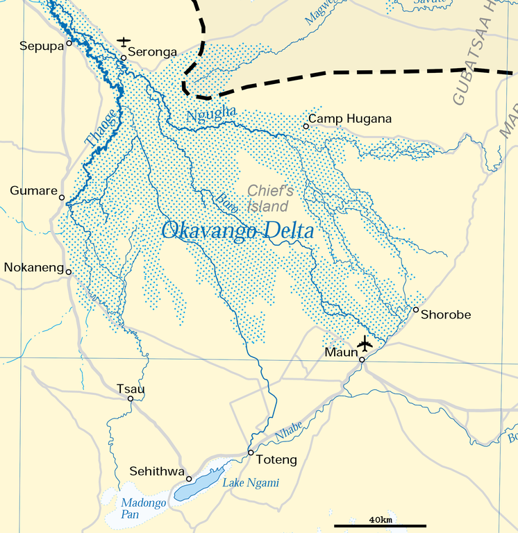
Deutsch: Karte des Okawangodeltas (vergrößerter Ausschnitt aus Datei Okavango River Basin map.png). Detaillierte Kartenlegende siehe dort.
English: Map of the Okavango delta (Botswana), expanded part of File:Okavango River Basin map.png. For detailled map legend see there.
|
| Data | |
| Źródło | http://www.un.org/Depts/Cartographic/map/profile/okavango.pdf (part) |
| Autor | United Nations |
| Licencja (Ponowne użycie tego pliku) |
UN map as PD |
| Inne wersje |
 |
| This image is a map derived from a United Nations map.
Unless stated otherwise, UN maps are to be considered in the public domain. This applies worldwide. UN maps are, in principle, open source material and you can use them in your work or for making your own map. UN requests however that you delete the UN name, logo and reference number upon any modification to the map. Content of your map will be your responsibility. You can state in your publication, if you wish, something like: based on UN map … (map name, map number, revision number and date). See: Geospatial Information Section. And: Geospatial, location data for a better world. |
 |
Historia pliku
Kliknij na datę/czas, aby zobaczyć, jak plik wyglądał w tym czasie.
| Data i czas | Miniatura | Wymiary | Użytkownik | Opis | |
|---|---|---|---|---|---|
| aktualny | 19:54, 27 cze 2018 | | 1860 × 1916 (733 KB) | Antonsusi | adding a scale |
| 08:45, 5 kwi 2016 |  | 1860 × 1916 (427 KB) | RokerHRO | optipng -zc1-9 -zm1-9 -zs0-3 -f0-5 -i0 → 41.70% decrease | |
| 14:55, 17 mar 2012 |  | 1860 × 1916 (733 KB) | Antonsusi | {{UN map}} |
Lokalne wykorzystanie pliku
Poniższa strona korzysta z tego pliku:
Globalne wykorzystanie pliku
Ten plik jest wykorzystywany także w innych projektach wiki:
- Wykorzystanie na af.wikipedia.org
- Wykorzystanie na ar.wikipedia.org
- Wykorzystanie na avk.wikipedia.org
- Wykorzystanie na az.wikipedia.org
- Wykorzystanie na bh.wikipedia.org
- Wykorzystanie na bn.wikipedia.org
- Wykorzystanie na ca.wikipedia.org
- Wykorzystanie na da.wikipedia.org
- Wykorzystanie na de.wikipedia.org
- Wykorzystanie na en.wikipedia.org
- Wykorzystanie na eo.wikipedia.org
- Wykorzystanie na es.wikipedia.org
- Wykorzystanie na et.wikipedia.org
- Wykorzystanie na fi.wikipedia.org
- Wykorzystanie na fr.wikipedia.org
- Wykorzystanie na hr.wikipedia.org
- Wykorzystanie na incubator.wikimedia.org
- Wykorzystanie na ka.wikipedia.org
- Wykorzystanie na ml.wikipedia.org
- Wykorzystanie na mt.wikipedia.org
- Wykorzystanie na nl.wikipedia.org
- Wykorzystanie na pt.wikipedia.org
- Wykorzystanie na ru.wikipedia.org
- Wykorzystanie na sh.wikipedia.org
- Wykorzystanie na sk.wikipedia.org
- Wykorzystanie na sl.wikipedia.org
- Wykorzystanie na sv.wikipedia.org
- Wykorzystanie na ta.wikipedia.org
- Wykorzystanie na tr.wikipedia.org
- Wykorzystanie na uk.wikipedia.org
- Wykorzystanie na vi.wikipedia.org
- Wykorzystanie na xmf.wikipedia.org
- Wykorzystanie na zh.wikipedia.org