Plik:Panstwo mieclawa.svg

Wielkość pliku podglądu PNG dla pliku SVG: 700 × 567 pikseli Inne rozdzielczości: 296 × 240 pikseli | 593 × 480 pikseli | 948 × 768 pikseli | 1264 × 1024 pikseli | 2529 × 2048 pikseli.
Rozmiar pierwotny (Plik SVG, nominalnie 700 × 567 pikseli, rozmiar pliku: 3,3 MB)
| Plik Panstwo mieclawa.svg znajduje się w Wikimedia Commons – repozytorium wolnych zasobów. Dane z jego strony opisu znajdują się poniżej. |
Opis
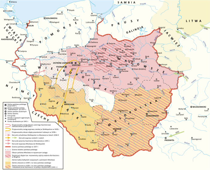
| Opis |
Polski: Państwo Miecława oraz granice Polski w 1037 roku |
| Data | |
| Źródło |
Praca własna Book source: Janusz Bieniak Państwo Miecława. Studium Analityczne, PWN, 2012 |
| Autor | Hoodinski |
| Inne wersje |

Licencja
Ja, właściciel praw autorskich do tego dzieła, udostępniam je na poniższej licencji
Ten plik udostępniony jest na licencji Creative Commons Uznanie autorstwa – Na tych samych warunkach 3.0.
- Wolno:
- dzielić się – kopiować, rozpowszechniać, odtwarzać i wykonywać utwór
- modyfikować – tworzyć utwory zależne
- Na następujących warunkach:
- uznanie autorstwa – musisz określić autorstwo utworu, podać link do licencji, a także wskazać czy utwór został zmieniony. Możesz to zrobić w każdy rozsądny sposób, o ile nie będzie to sugerować, że licencjodawca popiera Ciebie lub Twoje użycie utworu.
- na tych samych warunkach – Jeśli zmienia się lub przekształca niniejszy utwór, lub tworzy inny na jego podstawie, można rozpowszechniać powstały w ten sposób nowy utwór tylko na podstawie tej samej lub podobnej licencji.
Historia pliku
Kliknij na datę/czas, aby zobaczyć, jak plik wyglądał w tym czasie.
| Data i czas | Miniatura | Wymiary | Użytkownik | Opis | |
|---|---|---|---|---|---|
| aktualny | 20:32, 11 lut 2024 | | 700 × 567 (3,3 MB) | +JMJ+ | Reverted to version as of 21:38, 18 December 2023 (UTC) - "jotvingiai iki 12–13 a. pietuose gyvenę iki Bugo upės (Brastos-Drohičino apylinkėse)" (https://www.vle.lt/straipsnis/jotvingiai/). "until the 12th-13th centuries, Yotvingians lived in the south up to the Bug river (in the vicinity of Lithuanian Brest-Drohiczyn)". Yotvingian borders are ahistorically minimalized in this map and inaccurately depicted as part of Poland despite that not being the case. |
| 19:24, 7 lut 2024 |  | 700 × 567 (3,21 MB) | Bornholm | Reverted to version as of 21:43, 25 November 2023 (UTC) The Yotvingians did not live further south than the course of the Narew rivers. This is confirmed archaeologically. There are also no reliable historical sources that confirm settlements south of this river. South of this river there are no traces of their settlement or other Baltic tribes. Invasions to the south were only robbery and never had a settlement character. | |
| 23:38, 18 gru 2023 |  | 700 × 567 (3,3 MB) | +JMJ+ | Reverted to version as of 16:12, 28 August 2023 (UTC) - revert to historically accurate version | |
| 23:43, 25 lis 2023 |  | 700 × 567 (3,21 MB) | Kamilhrub | Reverted to version as of 10:48, 22 May 2023 (UTC) as in book source | |
| 18:12, 28 sie 2023 |  | 700 × 567 (3,3 MB) | +JMJ+ | Reverted to version as of 10:07, 16 May 2023 (UTC) - https://www.vle.lt/straipsnis/jotvingiai/ says that "the Jotvingians lived in the south up to the Bug river (in the vicinity of Brasta-Drohičin) until the 12th-13th century." | |
| 12:48, 22 maj 2023 |  | 700 × 567 (3,21 MB) | Bornholm | Reverted to version as of 14:43, 27 March 2023 (UTC) The Yotvingians did not live further south than the course of the Narew rivers. This is confirmed archaeologically. There are also no reliable historical sources that confirm settlements south of this river. South of this river there are no traces of their settlement or other Baltic tribes. Invasions to the south were only robbery and never had a settlement character. | |
| 12:07, 16 maj 2023 |  | 700 × 567 (3,3 MB) | +JMJ+ | Reverted to version as of 07:52, 25 February 2023 (UTC) Yotvingians were indeed inhabiting that far south - they were fighting for their native lands there against various Slavs (including the Poles) still in the 12th century | |
| 16:43, 27 mar 2023 |  | 700 × 567 (3,21 MB) | Bornholm | Correction of the Polish border with Yotvingians. Yotvingian tribes never had settlements so far south and never reached the Bug river. | |
| 09:52, 25 lut 2023 |  | 700 × 567 (3,3 MB) | ZxcvU | Przemysl was under Kyivan Rus' control since Yaroslav's March on Poland in 1031 | |
| 18:18, 17 lut 2023 |  | 700 × 567 (3,29 MB) | +JMJ+ | Corrections of Poland's eastern borders. Yotvingia was far larger at the time. |
Lokalne wykorzystanie pliku
Następujące strony korzystają z tego pliku:
- Bitwa Kazimierza I z Miecławem
- Historia Polski (do 1138)
- Kazimierz I Odnowiciel
- Mazowsze
- Mazury
- Miecław
- Monarchia wczesnopiastowska
- Najazd Brzetysława
- Państwo Miecława
- Powstanie ludowe w Polsce
- Reakcja pogańska
- Układ ratyzboński
- Wikipedysta:Hoodinski
- Wikipedysta:Luki1223/brudnopis
- Wikipedysta:Malarz pl/szablony/Państwo infobox
- Wikipedysta:Malarz pl/szablony/Państwo infobox/26
Globalne wykorzystanie pliku
Ten plik jest wykorzystywany także w innych projektach wiki:
- Wykorzystanie na de.wikipedia.org
- Wykorzystanie na en.wikipedia.org
- Wykorzystanie na ja.wikipedia.org
- Wykorzystanie na mt.wikipedia.org
- Wykorzystanie na ru.wikipedia.org
- Wykorzystanie na sl.wikipedia.org
- Wykorzystanie na sv.wikipedia.org
- Wykorzystanie na uk.wikipedia.org
- Wykorzystanie na www.wikidata.org