Plik:Parque Nacional Llullaillaco - NASA Earth Observatory.jpg

Rozmiar pierwotny (720 × 720 pikseli, rozmiar pliku: 129 KB, typ MIME: image/jpeg)
| Plik Parque Nacional Llullaillaco - NASA Earth Observatory.jpg znajduje się w Wikimedia Commons – repozytorium wolnych zasobów. Dane z jego strony opisu znajdują się poniżej. |
Opis
| Opis |
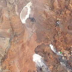
To download the full high res go to: earthobservatory.nasa.gov/IOTD/view.php?id=72520&src=... In the Andes Mountains, along the border between Chile and Argentina, lies Llullaillaco Volcano. With an elevation of 6,739 meters (22,109 feet) above sea level, the volcano is the world’s second-highest active volcano after Nevados Ojos del Salado, farther south in the Andes. Llullaillaco’s last recorded eruption occurred in 1877. Llullaillaco is a stratvolcano composed of alternating layers of hardened lava, solidified ash, and rocks ejected by earlier eruptions. The volcano sits atop an older volcano that collapsed about 150,000 years ago. Viscous, thick lava flows from Llullaillaco have formed visually stunning structures known as coulées. Llullaillaco Volcano has lent its name to a national park in Chile—Parque Nacional Llullaillaco—which extends west and south of the volcano. The Enhanced Thematic Mapper Plus on the Landsat 7 satellite acquired this natural-color image of the park on February 4, 2003. Park boundaries are outlined in white. Some snow and ice linger on the slopes of Llullaillaco, but little vegetation appears in this landscape. The clearest patch of green occurs in a lake east of the park. This landscape is a combination of mostly bare peaks and salt pans—the large, nearly white areas south and west of the volcano. Llullaillaco lies along the eastern margin of the Atacama Desert, one of the driest places on Earth. Though there were some recent snowfalls in the area, precipitation is rarely recorded in many parts of the Atacama. Pockets of plants do eke out a living in the region, especially where steep mountains block the movement of fog and allow moisture to collect. The plants provide food for local herbivores, and Parque Nacional Llullaillaco is home to guanacos and vicuñas. Llullaillaco is also an important archaeological site. In 1999, three Inca mummies were recovered from the summit, having been well preserved by cold, dry conditions. NASA Earth Observatory image created by Robert Simmon, using Landsat data provided by the United States Geological Survey. Caption by Michon Scott. The Earth Observatory’s mission is to share with the public the images, stories, and discoveries about climate and the environment that emerge from NASA research, including its satellite missions, in-the-field research, and climate models. Like us on Facebook Follow us on Twitter |
| Data | |
| Źródło | Parque Nacional Llullaillaco |
| Autor | NASA's Earth Observatory |
| Pozycja fotografa | | To i inne zdjęcia na: OpenStreetMap |
|---|
Licencja
- Wolno:
- dzielić się – kopiować, rozpowszechniać, odtwarzać i wykonywać utwór
- modyfikować – tworzyć utwory zależne
- Na następujących warunkach:
- uznanie autorstwa – musisz określić autorstwo utworu, podać link do licencji, a także wskazać czy utwór został zmieniony. Możesz to zrobić w każdy rozsądny sposób, o ile nie będzie to sugerować, że licencjodawca popiera Ciebie lub Twoje użycie utworu.
| Ten plik, opublikowany pierwotnie w serwisie Flickr przez NASA Earth Observatory pod adresem https://www.flickr.com/photos/68824346@N02/6283871000, został sprawdzony 2 lipca 2012 przez FlickreviewR, który potwierdził, że jest on tam dostępny na licencji cc-by-2.0. |
Historia pliku
Kliknij na datę/czas, aby zobaczyć, jak plik wyglądał w tym czasie.
| Data i czas | Miniatura | Wymiary | Użytkownik | Opis | |
|---|---|---|---|---|---|
| aktualny | 19:22, 2 lip 2012 | | 720 × 720 (129 KB) | Dzlinker | == {{int:filedesc}} == {{Information |Description=To download the full high res go to: [http://earthobservatory.nasa.gov/IOTD/view.php?id=72520&src=flickr earthobservatory.nasa.gov/IOTD/view.php?id=72520&src=...] In the Andes Mountains, along the bord... |
Lokalne wykorzystanie pliku
Poniższa strona korzysta z tego pliku: