Plik:Saint Helena Island.jpg

Rozmiar pierwotny (1440 × 1080 pikseli, rozmiar pliku: 634 KB, typ MIME: image/jpeg)
| Plik Saint Helena Island.jpg znajduje się w Wikimedia Commons – repozytorium wolnych zasobów. Dane z jego strony opisu znajdują się poniżej. |
Opis

|
Ta grafika została oceniona wg kryteriów dla wartościowych grafik i jest uważana za najbardziej wartościową grafikę na Commons w zakresie: (ang.) Saint Helena Island. Nominacja znajduje się na stronie Commons:Valued image candidates/Saint Helena Island.jpg. |
| Opis |
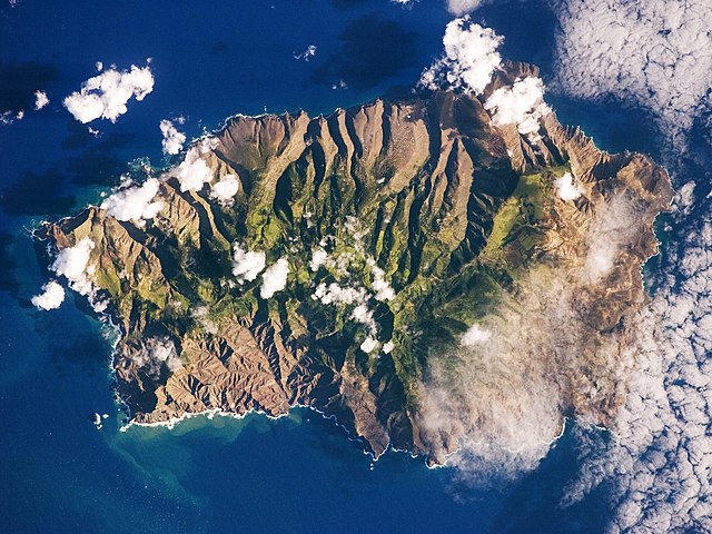
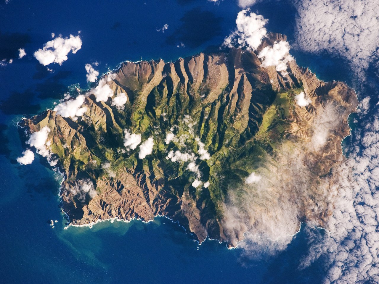
English: This astronaut photograph shows the island’s sharp peaks and deep ravines; the rugged topography results from erosion of the volcanic rocks that make up the island. The change in elevation from the coast to the interior creates a climate gradient. The higher, wetter centre is covered with green vegetation, whereas the lower coastal areas are drier and hotter, with little vegetation cover.
Français : Photo de l'île de Sainte Hélène prise par un astronaute de la NASA. On peut voir les pics élevés de l'île et ses ravines profondes. Cette topographie accidentée résulte de l'action de l'érosion sur les roches volcaniques dont l'île est constituée. Le changement d'élévation entre la périphérie et le centre de l'île créé un gradient climatique: le sommet est plus frais et humide, il est couvert de végétation. Les côtes, plus chaudes et sèches, laissent apparaitre la roche nue.
|
||||||||||||||||||||||||||||||||||||||||||||||||||||||
| Data | |||||||||||||||||||||||||||||||||||||||||||||||||||||||
| Źródło | NASA Earth Observatory | ||||||||||||||||||||||||||||||||||||||||||||||||||||||
| Autor | This image was taken by the NASA Expedition 19 crew. | ||||||||||||||||||||||||||||||||||||||||||||||||||||||
| Inne wersje |
|
||||||||||||||||||||||||||||||||||||||||||||||||||||||

| Pozycja fotografa | | To i inne zdjęcia na: OpenStreetMap |
|---|
This photograph was acquired with a Nikon 2DXs digital camera fitted with a 400 mm lens, and is provided by the ISS Crew Earth Observations experiment and Image Science & Analysis Laboratory, Johnson Space Centre.
Deutsch: Dieses Bild wurde als Bild der Woche auf der tschechischen Wikipedia für die 5 Woche ausgewählt, 2016. English: This image was selected as a picture of the week on the Czech Wikipedia for 5th week, 2016. Français : Cette image est sélectionnée en tant qu’image de la semaine sur la Wikipédia Tchèque pour la 5e semaine de 2016. Italiano: Questa immagine è stata selezionata come Immagine della settimana su Wikipedia in ceco per la V settimana del 2016. Македонски: Сликава е избрана за слика на неделата на чешката Википедија за V недела од 2016 година. Русский: Эта иллюстрация была выбрана изображением недели в чешском разделе «Википедии» для недели номер 5 2016 года. Українська: Ця ілюстрація була вибрана зображенням тижня в чеському розділі «Вікіпедії» для тижня номер 5, 2016 року. |
Licencja
| Ten plik jest w domenie publicznej ponieważ został stworzony przez NASA. Polityka praw autorskich NASA stwierdza, że „materiały NASA nie są chronione prawami autorskimi, chyba że zapisano inaczej”. (NASA copyright policy lub JPL Image Use Policy). | ||
 |
Uwaga:
|
| Adnotacje | To zdjęcie jest opatrzone adnotacją: Zobacz adnotacje w Commons |
Historia pliku
Kliknij na datę/czas, aby zobaczyć, jak plik wyglądał w tym czasie.
| Data i czas | Miniatura | Wymiary | Użytkownik | Opis | |
|---|---|---|---|---|---|
| aktualny | 13:28, 23 mar 2015 | | 1440 × 1080 (634 KB) | Julian Herzog | Reverted to version as of 18:00, 19 March 2015, rotation was done then. |
| 10:00, 20 mar 2015 |  | 1440 × 1080 (634 KB) | SteinsplitterBot | Bot: Image rotated by 180° | |
| 20:00, 19 mar 2015 |  | 1440 × 1080 (634 KB) | SteinsplitterBot | Bot: Image rotated by 180° | |
| 11:40, 15 cze 2009 |  | 1440 × 1080 (622 KB) | Originalwana | {{Information |Description={{en|1=This astronaut photograph shows the island’s sharp peaks and deep ravines; the rugged topography results from erosion of the volcanic rocks that make up the island. The change in elevation from the coast to the interior |
Lokalne wykorzystanie pliku
Następujące strony korzystają z tego pliku:
Globalne wykorzystanie pliku
Ten plik jest wykorzystywany także w innych projektach wiki:
- Wykorzystanie na als.wikipedia.org
- Wykorzystanie na ar.wikipedia.org
- Wykorzystanie na arz.wikipedia.org
- Wykorzystanie na ast.wikipedia.org
- Wykorzystanie na az.wikipedia.org
- Wykorzystanie na be.wikipedia.org
- Wykorzystanie na bg.wikipedia.org
- Wykorzystanie na br.wikipedia.org
- Wykorzystanie na bs.wikipedia.org
- Wykorzystanie na ca.wikipedia.org
- Wykorzystanie na ceb.wikipedia.org
- Wykorzystanie na ce.wikipedia.org
- Wykorzystanie na co.wikipedia.org
- Wykorzystanie na cs.wikipedia.org
- Wykorzystanie na da.wikipedia.org
- Wykorzystanie na de.wikipedia.org
- Wykorzystanie na en.wikipedia.org
- Wykorzystanie na en.wikiversity.org
- Wykorzystanie na eo.wikipedia.org
- Wykorzystanie na es.wikipedia.org
- Wykorzystanie na es.wiktionary.org
- Wykorzystanie na fi.wiktionary.org
- Wykorzystanie na frp.wikipedia.org
- Wykorzystanie na fr.wikipedia.org
- Wykorzystanie na fr.wikivoyage.org
- Wykorzystanie na ga.wikipedia.org
- Wykorzystanie na gl.wikipedia.org
- Wykorzystanie na he.wikipedia.org
- Wykorzystanie na hy.wikipedia.org
- Wykorzystanie na ig.wikipedia.org
- Wykorzystanie na it.wikipedia.org
Pokaż listę globalnego wykorzystania tego pliku.