Plik:Balkan peninsula line.jpg
Grafika w wyższej rozdzielczości nie jest dostępna.
Balkan_peninsula_line.jpg (558 × 530 pikseli, rozmiar pliku: 169 KB, typ MIME: image/jpeg)
| Plik Balkan peninsula line.jpg znajduje się w Wikimedia Commons – repozytorium wolnych zasobów. Dane z jego strony opisu znajdują się poniżej. |
Opis
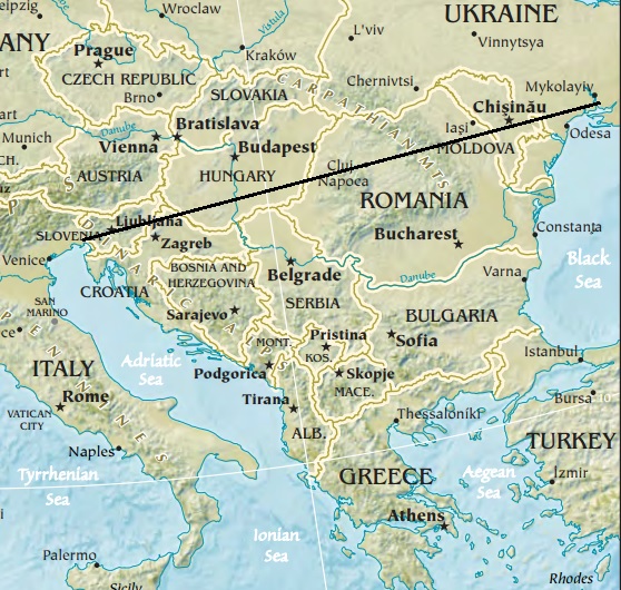
| Opis | Map of the Balkan peninsula, showing the line stretching from the northernmost point of the Adriatic to the northernmost point of the Black Sea. Made from Europe map at The Central Intelligence Agency World Factbook, which is in the public domain. |
| Źródło | https://www.cia.gov/library/publications/the-world-factbook//graphics/ref_maps/physical/jpg/europe.jpg |
| Autor | CIA |
| Inne wersje |
|
.jpg)
Licencja
Ten obrazek należy do domeny publicznej, bo zawiera materiały pochodzące z World Factbook należącej do amerykańskiej Centralnej Agencji Wywiadowczej (CIA).
|
 |

|
Ta grafika (map) (lub wszystkie grafiki w tym artykule bądź kategorii) powinny zostać przetworzone na grafiki wektorowe jako plik SVG. O zaletach grafik wektorowych można przeczytać na stronie Commons:Media for cleanup. Jeśli wersja SVG tej grafiki jest już dostępna, załaduj ją. Po załadowaniu SVG zamień ten szablon na stronie tej grafiki na szablon {{vector version available|nazwa nowej grafiki.svg}}.
|


Historia pliku
Kliknij na datę/czas, aby zobaczyć, jak plik wyglądał w tym czasie.
| Data i czas | Miniatura | Wymiary | Użytkownik | Opis | |
|---|---|---|---|---|---|
| aktualny | 14:27, 16 sty 2014 | | 558 × 530 (169 KB) | Denniss | Reverted to version as of 22:51, 26 December 2013 |
| 23:21, 15 sty 2014 |  | 348 × 382 (43 KB) | Ivan VA | stop vandalizing maps | |
| 00:51, 27 gru 2013 |  | 558 × 530 (169 KB) | No More Cats | Please don't revert to outdated versions of maps | |
| 00:43, 27 gru 2013 |  | 348 × 382 (43 KB) | Nikola Smolenski | Reverted to version as of 19:13, 3 November 2006 | |
| 18:06, 17 gru 2013 |  | 558 × 530 (169 KB) | No More Cats | Map of the Balkan peninsula, showing the line stretching from the northernmost point of the Adriatic to the northernmost point of the Black Sea. Made from most recent map at [https://www.cia.gov/cia/publications/factbook/reference_maps/jpg/europe.jpg]. | |
| 21:13, 3 lis 2006 |  | 348 × 382 (43 KB) | Nikola Smolenski | Map of the Balkan peninsula, showing the line stretching from the northernmost point of the Adriatic to the northernmost point of the Black Sea. Made from map at [https://www.cia.gov/cia/publications/factbook/reference_maps/jpg/europe.jpg]. |
Lokalne wykorzystanie pliku
Żadna strona nie korzysta z tego pliku.