Plik:ChaleurBay23.jpg
ChaleurBay23.jpg (300 × 202 pikseli, rozmiar pliku: 11 KB, typ MIME: image/jpeg)
| Plik ChaleurBay23.jpg znajduje się w Wikimedia Commons – repozytorium wolnych zasobów. Dane z jego strony opisu znajdują się poniżej. |
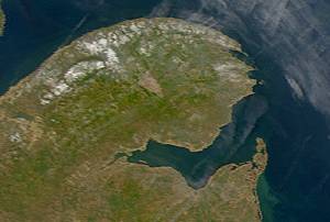
Description: Satellite image of Chaleur Bay below the Gaspé Peninsula.
From: SeaWiFS Level 1A image of the Canadian Maritime provinces and northeastern United States, acquired May 18, 2003.
Source: NASA Goddard Earth Sciences Data and Information Services Center
| This image is from the Sea-viewing Wide Field-of-view Sensor (SeaWiFS) Project and more than 5 years old.
Satellite data captured by the SeaWIFS sensor are released into the public domain 5 years after capture. Data less than five years old can be re-used only for educational or scientific purposes; any commercial use of such images must be coordinated with GeoEye. [1] |
| Ten utwór został udostępniony jako własność publiczna przez jego właściciela praw autorskich, GeoEye. Dotyczy to całego świata. W niektórych krajach może nie być to prawnie możliwe, jeśli tak, to: GeoEye zapewnia każdemu prawo do użycia tej pracy w dowolnym celu, bez żadnych ograniczeń, chyba że te ograniczenia są wymagane przez prawo.
|
Historia pliku
Kliknij na datę/czas, aby zobaczyć, jak plik wyglądał w tym czasie.
| Data i czas | Miniatura | Wymiary | Użytkownik | Opis | |
|---|---|---|---|---|---|
| aktualny | 11:13, 25 maj 2005 | | 300 × 202 (11 KB) | Big iron | Description: Satellite image of Chaleur Bay From: SeaWiFS Level 1A image of the Canadian Maritime provinces and northeastern United States, acquired May 18, 2003. Source: NASA Goddard Earth Sciences Data and Information Services Center {{PD-USGov-NASA} |
Lokalne wykorzystanie pliku
Poniższa strona korzysta z tego pliku:
Globalne wykorzystanie pliku
Ten plik jest wykorzystywany także w innych projektach wiki:
- Wykorzystanie na ca.wikipedia.org
- Wykorzystanie na ceb.wikipedia.org
- Wykorzystanie na de.wikipedia.org
- Wykorzystanie na en.wikipedia.org
- Wykorzystanie na eo.wikipedia.org
- Wykorzystanie na es.wikipedia.org
- Wykorzystanie na fr.wikipedia.org
- Wykorzystanie na incubator.wikimedia.org
- Wykorzystanie na it.wikipedia.org
- Wykorzystanie na nl.wikipedia.org
- Wykorzystanie na no.wikipedia.org
- Wykorzystanie na pt.wikipedia.org
- Wykorzystanie na ru.wikipedia.org
- Wykorzystanie na uk.wikipedia.org
- Wykorzystanie na www.wikidata.org