Plik:Challenger Deep EM124 Sonar Map and Diving History 101119.jpg
Rozmiar podglądu – 800 × 366 pikseli. Inne rozdzielczości: 320 × 146 pikseli | 640 × 292 pikseli | 1278 × 584 pikseli.
Rozmiar pierwotny (1278 × 584 pikseli, rozmiar pliku: 141 KB, typ MIME: image/jpeg)
| Plik Challenger Deep EM124 Sonar Map and Diving History 101119.jpg znajduje się w Wikimedia Commons – repozytorium wolnych zasobów. Dane z jego strony opisu znajdują się poniżej. |
Opis
| Opis |
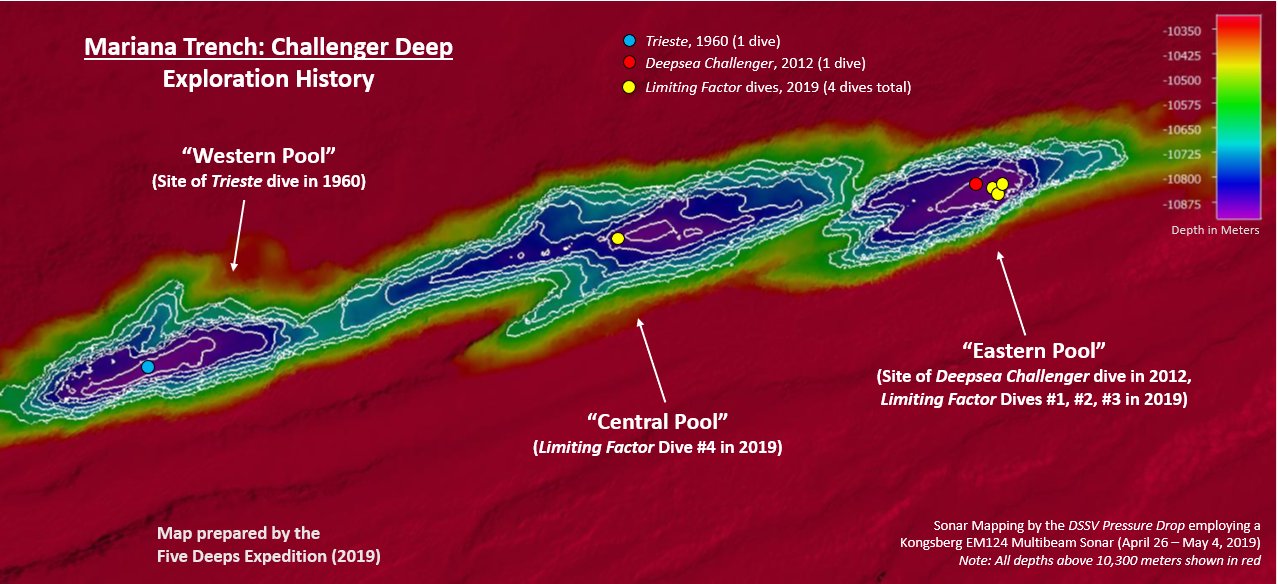
English: This map was created by the DSSV Pressure Drop's Kngsberg EM124 sonar system over the course of two weeks to map the Challenger Deep in the Marianas Trench. The Deep consists of three "pools" of varying depth with the central pool being the most shallow, then the western one, with the eastern pool measured to be the deepest at 10,925 meters. That depth was measured using the manned submersible DSV Limiting Factor on April 28 - May 3, 2019 as part of the Five Deeps Expedition. |
| Data | |
| Źródło | Praca własna |
| Autor | Vlvescovo |
Licencja
Ja, właściciel praw autorskich do tego dzieła, udostępniam je na poniższej licencji
Ten plik udostępniony jest na licencji Creative Commons Uznanie autorstwa – Na tych samych warunkach 4.0 Międzynarodowe.
- Wolno:
- dzielić się – kopiować, rozpowszechniać, odtwarzać i wykonywać utwór
- modyfikować – tworzyć utwory zależne
- Na następujących warunkach:
- uznanie autorstwa – musisz określić autorstwo utworu, podać link do licencji, a także wskazać czy utwór został zmieniony. Możesz to zrobić w każdy rozsądny sposób, o ile nie będzie to sugerować, że licencjodawca popiera Ciebie lub Twoje użycie utworu.
- na tych samych warunkach – Jeśli zmienia się lub przekształca niniejszy utwór, lub tworzy inny na jego podstawie, można rozpowszechniać powstały w ten sposób nowy utwór tylko na podstawie tej samej lub podobnej licencji.
Historia pliku
Kliknij na datę/czas, aby zobaczyć, jak plik wyglądał w tym czasie.
| Data i czas | Miniatura | Wymiary | Użytkownik | Opis | |
|---|---|---|---|---|---|
| aktualny | 00:06, 12 paź 2019 | | 1278 × 584 (141 KB) | Vlvescovo | User created page with UploadWizard |
Lokalne wykorzystanie pliku
Poniższa strona korzysta z tego pliku:
Globalne wykorzystanie pliku
Ten plik jest wykorzystywany także w innych projektach wiki:
- Wykorzystanie na ar.wikipedia.org
- Wykorzystanie na de.wikipedia.org
- Wykorzystanie na en.wikipedia.org
- Wykorzystanie na ga.wikipedia.org
- Wykorzystanie na ka.wikipedia.org
- Wykorzystanie na lv.wikipedia.org