Plik:DEU Melle COA.svg

Wielkość pliku podglądu PNG dla pliku SVG: 412 × 472 pikseli Inne rozdzielczości: 209 × 240 pikseli | 419 × 480 pikseli | 670 × 768 pikseli | 894 × 1024 pikseli | 1788 × 2048 pikseli.
Rozmiar pierwotny (Plik SVG, nominalnie 412 × 472 pikseli, rozmiar pliku: 3 KB)
| Plik DEU Melle COA.svg znajduje się w Wikimedia Commons – repozytorium wolnych zasobów. Dane z jego strony opisu znajdują się poniżej. |
Opis
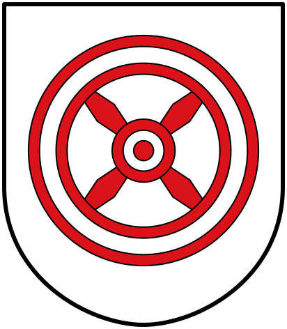
| Herb | Français : de la ville allemande de Melle |
| Blazonowanie | Deutsch: „Die Stadt Melle führt als Wappen ein vierspeichiges rotes Rad mit schräger Speichenstellung auf einem silbernen Schild.“Heraldisch besser:„In Silber ein rotes Rad mit vier schräggekreuzten Speichen.“ English: “Argent a wheel spoked of four in saltire Gules.” Français : « D'argent à la roue à quatre rayons en sautoir de gueules. » |
| Referencja blazonowania | Deutsch: §1 der Hauptsatzung der Stadt Melle |
| Tynktura | argentgules |
| Data |
Deutsch: zuletzt verliehen 1964 English: last granted in 1964 Français : décoré en dernier 1964 |
| Historia obiektu |
Deutsch: Das erstmals 1939 durch preußischen Ministerialerlass und 1964 vom niedersächsischen Innenministerium zuletzt genehmigte Wappen ist abgeleitet vom Wappen des Bistums Osnabrück, welches sechs Speichen zeigt. English: The arms were officially granted in 1939 and confirmed in 1964. They are derived from the arms of the Diocese of Osnabrück. |
| Artysta | |
| Źródło | Website der Stadt Melle |
| Inne wersje |
 |
| SVG rozwój | Kod źródłowy tego poprawny. |
Licencja
This file depicts the coat of arms of a German Körperschaft des öffentlichen Rechts (corporation governed by public law). According to § 5 Abs. 1 of the German Copyright law, official works like coats of arms are in the public domain.
Note: The usage of coats of arms is governed by legal restrictions, independent of the copyright status of the depiction shown here.
|
 |
| Pozycja obiektu | | To i inne zdjęcia na: OpenStreetMap |
|---|
Historia pliku
Kliknij na datę/czas, aby zobaczyć, jak plik wyglądał w tym czasie.
| Data i czas | Miniatura | Wymiary | Użytkownik | Opis | |
|---|---|---|---|---|---|
| aktualny | 12:10, 5 sie 2016 | | 412 × 472 (3 KB) | Jürgen Krause | redrawn refered to city charta - https://www.melle.info/downloads/datei/OTE5MDAwMjE5Oy07L3Vzci9sb2NhbC9odHRwZC92aHRkb2NzL21lbGxlL21lbGxlL21lZGllbi9kb2t1bWVudGUvMTBfMV9oYXVwdHNhdHp1bmdfMjAxMS4xMS4wMi5wZGY%3D/10_1_hauptsatzung_2011.11.02.pdf |
| 14:23, 5 cze 2009 |  | 500 × 541 (12 KB) | Hagar66 | {{Information |Description= |Source= |Date= |Author= |Permission= |other_versions= }} | |
| 13:55, 5 cze 2009 |  | 500 × 541 (511 bajtów) | Hagar66 | {{COAInformation |blasonde=Stadt Melle |blasonnement-de=„Vierspeichiges rotes Rad mit schräger Speichenstellung auf einem silbernen (weißen) Schild“ |ref-de= |blasonen=city of [[:Category:Melle (Lower Saxony)|Melle |
Lokalne wykorzystanie pliku
Następujące strony korzystają z tego pliku:
Globalne wykorzystanie pliku
Ten plik jest wykorzystywany także w innych projektach wiki:
- Wykorzystanie na azb.wikipedia.org
- Wykorzystanie na da.wikipedia.org
- Wykorzystanie na de.wikipedia.org
- Wykorzystanie na es.wikipedia.org
- Wykorzystanie na et.wikipedia.org
- Wykorzystanie na fa.wikipedia.org
- Wykorzystanie na id.wikipedia.org
- Wykorzystanie na it.wikipedia.org
- Wykorzystanie na ja.wikipedia.org
- Wykorzystanie na lv.wikipedia.org
- Wykorzystanie na ms.wikipedia.org
- Wykorzystanie na nl.wikipedia.org
- Wykorzystanie na pt.wikipedia.org
- Wykorzystanie na ru.wikipedia.org
- Wykorzystanie na sh.wikipedia.org
- Wykorzystanie na sr.wikipedia.org
- Wykorzystanie na sv.wikipedia.org
- Wykorzystanie na tr.wikipedia.org
- Wykorzystanie na uk.wikipedia.org
- Wykorzystanie na vi.wikipedia.org
- Wykorzystanie na vo.wikipedia.org