Plik:Diakopto-Kalavrita-Chelmos-Landsat7 WW texted.jpg

Rozmiar podglądu – 800 × 581 pikseli. Inne rozdzielczości: 320 × 232 pikseli | 640 × 465 pikseli | 1024 × 744 pikseli | 1280 × 930 pikseli | 1600 × 1162 pikseli.
Rozmiar pierwotny (1600 × 1162 pikseli, rozmiar pliku: 2 MB, typ MIME: image/jpeg)
| Plik Diakopto-Kalavrita-Chelmos-Landsat7 WW texted.jpg znajduje się w Wikimedia Commons – repozytorium wolnych zasobów. Dane z jego strony opisu znajdują się poniżej. |
| Opis |
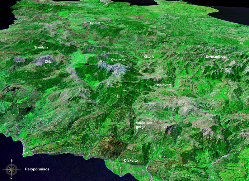
Peloponnese, north==>south, altitude: 20 km; Landsat7, GeoCover 2000, res. 15m/pix |
| Data | |
| Źródło | installed WW-Software needed: worldwind://goto/world=Earth&lat=38.05234&lon=22.18076&alt=20000&dir=180&tilt=60 |
| Autor | Fotografia: NASA |
| This image is in the public domain because it is a screenshot from NASA’s globe software World Wind using a public domain layer, such as Blue Marble, MODIS, Landsat, SRTM, USGS or GLOBE.
|
 |
Historia pliku
Kliknij na datę/czas, aby zobaczyć, jak plik wyglądał w tym czasie.
| Data i czas | Miniatura | Wymiary | Użytkownik | Opis | |
|---|---|---|---|---|---|
| aktualny | 00:22, 3 paź 2006 | | 1600 × 1162 (2 MB) | Ulrichstill | {{Information| |Description = Peloponnese, north==>south, altitude: 20 km; Landsat7, GeoCover 2000, res. 15m/pix <br> Vorne: Golf von Korinth; Schwemmkegel des Flusses Vouraikos bei Diakoptó. Das nach Kalavrita beginnende Gefälle des Flusses schuf die S |
Lokalne wykorzystanie pliku
Poniższa strona korzysta z tego pliku:
Globalne wykorzystanie pliku
Ten plik jest wykorzystywany także w innych projektach wiki:
- Wykorzystanie na de.wikipedia.org
- Wykorzystanie na el.wikipedia.org
- Wykorzystanie na it.wikipedia.org
- Wykorzystanie na ru.wikipedia.org
- Wykorzystanie na www.wikidata.org