Plik:Gloster Javelin FAW1 (50116110362).jpg

Rozmiar pierwotny (6000 × 4000 pikseli, rozmiar pliku: 6,64 MB, typ MIME: image/jpeg)
| Plik Gloster Javelin FAW1 (50116110362).jpg znajduje się w Wikimedia Commons – repozytorium wolnych zasobów. Dane z jego strony opisu znajdują się poniżej. |
.jpg)
Opis
| Opis |
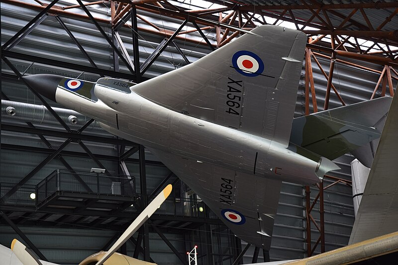
Gloster Javelin FAW1 at the RAF Museum, Cosford, Shropshire, 8 July 2020. The Gloster Javelin was designed to meet the RAF’s first specifications for a jet night fighter (in 1946 & 1948) to equip all night and all-weather fighter squadrons by 1952. Unfortunately, problems developing the Javelin meant that it looked very unlikely this target could be met, exacerbated by further delays due to an economy drive by the government. Interim night fighter adaptations of, first, the Gloster Meteor, then the de Havilland Vampire and then the de Havilland Venom had to be procured. But the Korean War changed things and suddenly the Javelin became a super-priority project. Armstrong-Whitworth were involved in providing support for the Javeln's development. For the time, the Javelin was a very advanced, radar-equipped design, the first twin-engined delta fighter in the world and designed to have a very high performance, a long endurance and the ability to intercept Soviet bombers at great altitude at transonic speeds. The first prototype flew in 1951 and five more followed until 1955 in order to perfect the design; however, several accidents occurred, which delayed the introduction of the FAW1 (first flight in 1954) into service until 1956. Several improved marks followed in relatively small numbers, the main version being the much improved FAW8 of 1958 with reheat and de Havilland Firestreak missiles. The even more improved FAW9, converted from FAW7’s, followed in 1960. Trainer versions were also produced. The Javelin finally left first line fighter service in 1968. It was also the last aircraft produced by Gloster. A prototype thin-wing, supersonic version with advanced Red Dean missiles was under construction in 1957 but was cancelled when a Defence Review saw no future in manned combat aircraft! |
| Data | |
| Źródło | Gloster Javelin FAW1 |
| Autor | Hugh Llewelyn from Keynsham, UK |
| Pozycja fotografa | | To i inne zdjęcia na: OpenStreetMap |
|---|
.jpg¶ms=052.642021_N_-002.309188_E_globe:Earth_type:camera_source:Flickr_&language=pl)
Licencja
- Wolno:
- dzielić się – kopiować, rozpowszechniać, odtwarzać i wykonywać utwór
- modyfikować – tworzyć utwory zależne
- Na następujących warunkach:
- uznanie autorstwa – musisz określić autorstwo utworu, podać link do licencji, a także wskazać czy utwór został zmieniony. Możesz to zrobić w każdy rozsądny sposób, o ile nie będzie to sugerować, że licencjodawca popiera Ciebie lub Twoje użycie utworu.
- na tych samych warunkach – Jeśli zmienia się lub przekształca niniejszy utwór, lub tworzy inny na jego podstawie, można rozpowszechniać powstały w ten sposób nowy utwór tylko na podstawie tej samej lub podobnej licencji.
| Ten plik, opublikowany pierwotnie w serwisie Flickr przez hugh llewelyn pod adresem https://flickr.com/photos/58433307@N08/50116110362, został sprawdzony 17 lipca 2020 przez FlickreviewR 2, który potwierdził, że jest on tam dostępny na licencji cc-by-sa-2.0. |
Historia pliku
Kliknij na datę/czas, aby zobaczyć, jak plik wyglądał w tym czasie.
| Data i czas | Miniatura | Wymiary | Użytkownik | Opis | |
|---|---|---|---|---|---|
| aktualny | 21:32, 17 lip 2020 | | 6000 × 4000 (6,64 MB) | Tm | Transferred from Flickr via #flickr2commons |
Lokalne wykorzystanie pliku
Poniższa strona korzysta z tego pliku:
.jpg)