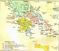
Plik:Greece in 1278.svg

Wielkość pliku podglądu PNG dla pliku SVG: 800 × 456 pikseli Inne rozdzielczości: 320 × 182 pikseli | 640 × 365 pikseli | 1024 × 584 pikseli | 1280 × 730 pikseli | 2560 × 1460 pikseli | 3508 × 2000 pikseli.
Rozmiar pierwotny (Plik SVG, nominalnie 3508 × 2000 pikseli, rozmiar pliku: 1014 KB)
Historia pliku
Kliknij na datę/czas, aby zobaczyć, jak plik wyglądał w tym czasie.
| Data i czas | Miniatura | Wymiary | Użytkownik | Opis | |
|---|---|---|---|---|---|
| aktualny | 22:04, 23 cze 2017 |  | 3508 × 2000 (1014 KB) | Cplakidas | fixed name |
| 14:14, 11 kwi 2017 |  | 3508 × 2000 (1017 KB) | Cplakidas | colour changes | |
| 20:22, 8 lut 2017 |  | 3508 × 2000 (1018 KB) | Cplakidas | text to paths | |
| 20:11, 8 lut 2017 |  | 3508 × 2000 (1002 KB) | Cplakidas | User created page with UploadWizard |
Lokalne wykorzystanie pliku
Poniższa strona korzysta z tego pliku:
Globalne wykorzystanie pliku
Ten plik jest wykorzystywany także w innych projektach wiki:
- Wykorzystanie na ar.wikipedia.org
- Wykorzystanie na az.wikipedia.org
- Wykorzystanie na bg.wikipedia.org
- Wykorzystanie na el.wikipedia.org
- Wykorzystanie na en.wikipedia.org
- Fourth Crusade
- Principality of Achaea
- Patras
- Battle of Halmyros
- History of Thessaly
- John I Doukas of Thessaly
- Nicholas III of Saint-Omer
- Nicholas II of Saint-Omer
- Matilda of Hainaut
- Boniface of Verona
- Battle of Neopatras
- Battle of Demetrias
- Lordship of Salona
- Jacopo Dondulo
- Byzantine–Venetian treaty of 1277
- Wykorzystanie na es.wikipedia.org
- Wykorzystanie na et.wikipedia.org
- Wykorzystanie na fa.wikipedia.org
- Wykorzystanie na fr.wikipedia.org
- Wykorzystanie na hr.wikipedia.org
- Wykorzystanie na hyw.wikipedia.org
- Wykorzystanie na it.wikipedia.org
- Wykorzystanie na ka.wikipedia.org
- Wykorzystanie na pt.wikipedia.org
- Wykorzystanie na ru.wikipedia.org
- Wykorzystanie na sq.wikipedia.org
- Wykorzystanie na sr.wikipedia.org
- Wykorzystanie na tr.wikipedia.org
- Wykorzystanie na uk.wikipedia.org
Pokaż listę globalnego wykorzystania tego pliku.


