Plik:Harwich Harbour 1804.png

Rozmiar podglądu – 449 × 599 pikseli. Inne rozdzielczości: 180 × 240 pikseli | 360 × 480 pikseli | 576 × 768 pikseli | 768 × 1024 pikseli | 2498 × 3331 pikseli.
Rozmiar pierwotny (2498 × 3331 pikseli, rozmiar pliku: 1012 KB, typ MIME: image/png)
| Plik Harwich Harbour 1804.png znajduje się w Wikimedia Commons – repozytorium wolnych zasobów. Dane z jego strony opisu znajdują się poniżej. |
Opis
| Opis |
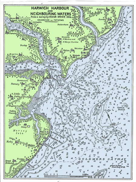
English: This is a chart of the approaches to Harwich and Felixstowe that was first published in 1804. This version is from a book: Orwell Estuary, the story of Ipswich River by W.G.Arnott. The sea and the land have been coloured to make the chart easier to read. |
| Data | |
| Źródło | Originally published in 1804 from a survey by Graeme Spence |
| Autor | Welkinridge |
Licencja
|
Ten materiał przeszedł do domeny publicznej w kraju pochodzenia, jak również w państwach i terytoriach, gdzie prawo autorskie wygasa w ciągu 100 lat po śmierci autora. | |
| Plik rozpoznano jako wolny od znanych ograniczeń praw autorskich, włącznie z prawami zależnymi i pokrewnymi. | |
Historia pliku
Kliknij na datę/czas, aby zobaczyć, jak plik wyglądał w tym czasie.
| Data i czas | Miniatura | Wymiary | Użytkownik | Opis | |
|---|---|---|---|---|---|
| aktualny | 21:01, 21 cze 2008 | | 2498 × 3331 (1012 KB) | Welkinridge | {{Information |Description={{en|1=This is a chart of the approaches to Harwich and Felixstowe that was first published in 1804. This version is from a book: Orwell Estuary, the story of Ipswich River by W.G.Arnott. The sea and the land have been coloured |
Lokalne wykorzystanie pliku
Poniższa strona korzysta z tego pliku:
Globalne wykorzystanie pliku
Ten plik jest wykorzystywany także w innych projektach wiki:
- Wykorzystanie na en.wikipedia.org