Plik:Kingdom of Prussia 1870.svg

Wielkość pliku podglądu PNG dla pliku SVG: 450 × 456 pikseli Inne rozdzielczości: 237 × 240 pikseli | 474 × 480 pikseli | 758 × 768 pikseli | 1011 × 1024 pikseli | 2021 × 2048 pikseli.
Rozmiar pierwotny (Plik SVG, nominalnie 450 × 456 pikseli, rozmiar pliku: 705 KB)
| Plik Kingdom of Prussia 1870.svg znajduje się w Wikimedia Commons – repozytorium wolnych zasobów. Dane z jego strony opisu znajdują się poniżej. |
Opis
Ta ^specifik^ z W3C grafika wektorowa została stworzona za pomocą Inkscape .


.svg)
.svg)
.svg)
.svg)
.svg)


.svg)
.svg)
.svg)


.png)
.png)


.svg)


.svg)

.svg)


.svg)
.svg)
.svg)
.svg)


.svg)
.png)


.svg)


.svg)
.svg)


.svg)


.svg)


.svg)
.svg)
.svg)
.svg)
.svg)
.svg)
.svg)
_cropped.svg)
.svg)
.svg)
.svg)
.svg)
.svg)
.svg)
.svg)
.svg)
.svg)
.svg)
.svg)
.svg)
.svg)
.svg)
.svg)
.svg)
.svg)
.svg)
.svg)
.svg)
.svg)
.svg)
.svg)
.svg)
.svg)
.svg)
.svg)
.svg)
.svg)
.svg)
.svg)
.svg)
.svg)
.svg)
.svg)
.svg)
.svg)
.svg)
.svg)
.svg)
.svg)
.svg)
.svg)
.svg)
.svg)
Licencja
Ten plik udostępniony jest na licencji Creative Commons Uznanie autorstwa – Na tych samych warunkach 4.0 Międzynarodowe.
- Wolno:
- dzielić się – kopiować, rozpowszechniać, odtwarzać i wykonywać utwór
- modyfikować – tworzyć utwory zależne
- Na następujących warunkach:
- uznanie autorstwa – musisz określić autorstwo utworu, podać link do licencji, a także wskazać czy utwór został zmieniony. Możesz to zrobić w każdy rozsądny sposób, o ile nie będzie to sugerować, że licencjodawca popiera Ciebie lub Twoje użycie utworu.
- na tych samych warunkach – Jeśli zmienia się lub przekształca niniejszy utwór, lub tworzy inny na jego podstawie, można rozpowszechniać powstały w ten sposób nowy utwór tylko na podstawie tej samej lub podobnej licencji.
Historia pliku
Kliknij na datę/czas, aby zobaczyć, jak plik wyglądał w tym czasie.
| Data i czas | Miniatura | Wymiary | Użytkownik | Opis | |
|---|---|---|---|---|---|
| aktualny | 04:54, 1 cze 2016 | | 450 × 456 (705 KB) | Alphathon | Various corrections to the states of the North German Confederation |
| 07:22, 31 maj 2016 |  | 450 × 456 (662 KB) | Alphathon | Minor corrections (Tarasp and post-1818 German Confederation border change) | |
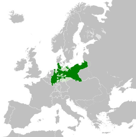
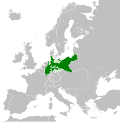
| 04:40, 31 maj 2016 |  | 450 × 456 (662 KB) | Alphathon | == {{int:filedesc}} == {{Inkscape}} {{Information |Description={{en|A map of the en:Kingdom of Prussia within the North German Confederation and within Europe circa 1870 CE.}} |Source= {{Derived from|Blank_map_of_Europe.svg|display=50}} |Da... |
Lokalne wykorzystanie pliku
Następujące strony korzystają z tego pliku:
Globalne wykorzystanie pliku
Ten plik jest wykorzystywany także w innych projektach wiki:
- Wykorzystanie na af.wiktionary.org
- Wykorzystanie na ar.wikipedia.org
- Wykorzystanie na bn.wikipedia.org
- Wykorzystanie na ckb.wikipedia.org
- Wykorzystanie na en.wikipedia.org
- Wykorzystanie na eo.wiktionary.org
- Wykorzystanie na es.wikipedia.org
- Wykorzystanie na es.wiktionary.org
- Wykorzystanie na eu.wikipedia.org
- Wykorzystanie na fa.wikipedia.org
- Wykorzystanie na fi.wikipedia.org
- Wykorzystanie na he.wikipedia.org
- Wykorzystanie na hu.wikipedia.org
- Wykorzystanie na is.wikipedia.org
- Wykorzystanie na it.wikipedia.org
- Wykorzystanie na li.wiktionary.org
- Wykorzystanie na lld.wikipedia.org
- Wykorzystanie na lt.wikipedia.org
- Wykorzystanie na mn.wikipedia.org
- Wykorzystanie na rue.wikipedia.org
- Wykorzystanie na ru.wikipedia.org
- Wykorzystanie na ru.wiktionary.org
- Wykorzystanie na sk.wikipedia.org
- Wykorzystanie na szl.wikipedia.org
- Wykorzystanie na tr.wikipedia.org
- Wykorzystanie na uk.wikipedia.org
- Wykorzystanie na uz.wikipedia.org
- Wykorzystanie na xmf.wikipedia.org
- Wykorzystanie na zh.wikipedia.org