Plik:Libya Montes.jpg
Rozmiar pierwotny (2174 × 987 pikseli, rozmiar pliku: 150 KB, typ MIME: image/jpeg)
| Plik Libya Montes.jpg znajduje się w Wikimedia Commons – repozytorium wolnych zasobów. Dane z jego strony opisu znajdują się poniżej. |
Opis
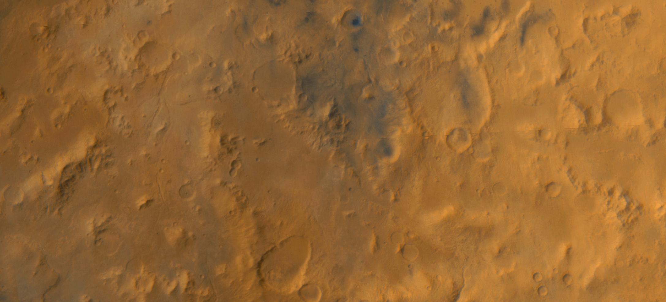
Original Caption Released with Image: The Libya Montes are a ring of mountains up-lifted by the giant impact that created the Isidis basin to the north. During 1999, this region became one of the top two that were being considered for the now-canceled Mars Surveyor 2001 Lander. The Isidis basin is very, very ancient. Thus, the mountains that form its rims would contain some of the oldest rocks available at the Martian surface, and a landing in this region might potentially provide information about conditions on early Mars. In May 1999, the wide angle cameras of the Mars Global Surveyor Mars Orbiter Camera system were used in what was called the "Geodesy Campaign" to obtain nearly global maps of the planet in color and in stereo at resolutions of 240 m/pixel (787 ft/pixel) for the red camera and 480 m/pixel (1575 ft/pixel) for the blue. Shown here are color and stereo views constructed from mosaics of the Geodesy Campaign images for the Libya Montes region of Mars. After they formed by giant impact, the Libya Mountains and valleys were subsequently modified and eroded by other processes, including wind, impact cratering, and flow of liquid water to make the many small valleys that can be seen running northward in the scene. The pictures shown here cover nearly 122,000 square kilometers (47,000 square miles) between latitudes 0.1°N and 4.0°N, longitudes 271.5°W and 279.9°W. The mosaics are about 518 km (322 mi) wide by 235 km (146 mi)high. Red-blue "3-D" glasses are needed to view the stereo image.
Image Credit: NASA/JPL/MSSS
Licencja
| Ten plik jest w domenie publicznej ponieważ został stworzony przez NASA. Polityka praw autorskich NASA stwierdza, że „materiały NASA nie są chronione prawami autorskimi, chyba że zapisano inaczej”. (NASA copyright policy lub JPL Image Use Policy). | ||
 |
Uwaga:
|
Historia pliku
Kliknij na datę/czas, aby zobaczyć, jak plik wyglądał w tym czasie.
| Data i czas | Miniatura | Wymiary | Użytkownik | Opis | |
|---|---|---|---|---|---|
| aktualny | 19:25, 12 kwi 2006 | | 2174 × 987 (150 KB) | Fabio Bettani | Original Caption Released with Image: The Libya Montes are a ring of mountains up-lifted by the giant impact that created the Isidis basin to the north. During 1999, this region became one of the top two that were being considered for the now-cancele |
Lokalne wykorzystanie pliku
Poniższa strona korzysta z tego pliku:
Globalne wykorzystanie pliku
Ten plik jest wykorzystywany także w innych projektach wiki:
- Wykorzystanie na en.wikipedia.org
- Wykorzystanie na es.wikipedia.org
- Wykorzystanie na it.wikipedia.org
- Wykorzystanie na sk.wikipedia.org
- Wykorzystanie na uk.wikipedia.org
- Wykorzystanie na zh.wikipedia.org