Plik:Monteregian Hills from space.jpg

Rozmiar pierwotny(2112 × 1304 pikseli, rozmiar pliku: 1,22 MB, typ MIME: image/jpeg)

Opis

Opis
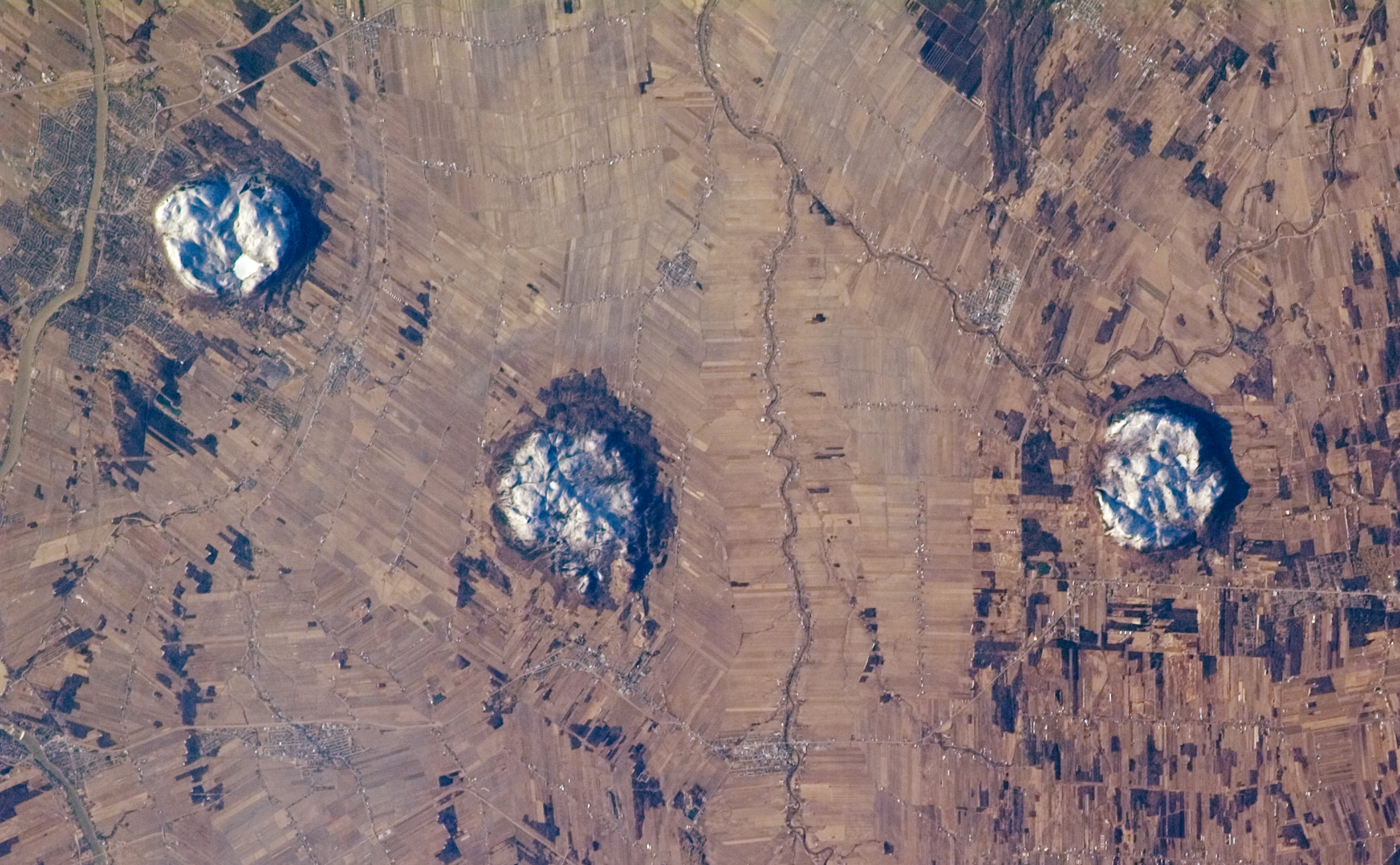
English: Astronaut photo of the Monteregian Hills, Quebec, Canada. Credit: International Space Station Crew Earth Observations experiment and the Image Science & Analysis Laboratory, Johnson Space Center The description from that page follows below.
  • This astronaut photograph of the area to the east of Montreal, Canada, captures two striking patterns. The circular features are the central members of a group of unusual rock formations known as the Monteregian Hills: Mont St. Hilaire, Rougemont, and Mont Yamaska. The rectangular pattern blanketing the landscape in the background reveals the intensive agriculture in the fertile lowlands in southern Quebec.
  • The Monteregian Hills are an isolated series of roughly east-west trending plutons, masses of igneous (volcanic) rock that crystallized below the land surface. The magmas that form the Hills intruded into pre-existing sedimentary rocks roughly 118 to 140 million years ago, during the Cretaceous Era. Over time, the sedimentary rock has eroded away, leaving the more resistant igneous rock of the plutons exposed as the Monteregian Hills, standing over the surrounding, flat St. Lawrence Plains.
  • Snow cover on the three mountains provides contrast with surrounding fallow agricultural fields, which are shades of brown and tan. A bright white circle nestled on top of Mont St. Hillaire is snow-covered Lac Hertel (Hertel Lake). In addition to their interesting geology, the Monteregian Hills also serve as important woodland habitat “islands” in the greater Montreal urban area. Several small town and cities are visible in the image, appearing as purplish-gray patches. The largest in the scene is the city of Beloeil, straddling the Richelieu River west of Mont St. Hilaire.
  • The featured astronaut photograph, ISS014-E-19807, was acquired April 18, 2007, with a Kodak 760C digital camera using an 180 mm lens, and is provided by the ISS Crew Earth Observations experiment and the Image Science & Analysis Laboratory, Johnson Space Center. The image in this article has been cropped and enhanced to improve contrast. The International Space Station Program supports the laboratory to help astronauts take pictures of Earth that will be of the greatest value to scientists and the public, and to make those images freely available on the Internet. Additional images taken by astronauts and cosmonauts can be viewed at the NASA/JSC Gateway to Astronaut Photography of Earth.
Français : Collines Montérégiennes vues de l'espace. Photo par un astraunaute des Collines Montérégiennes, Québec, Canada. Crédit: expérience de International Space Station Crew Earth Observations, adaptation et traduction de la description faite par Image Science & Analysis Laboratory, Johnson Space Center.
  • Cette photographie astraunautique de la région sise à l'est de Montréal capte deux modèles géomorphologiques contrastants. Les trois formes circulaires sont les composantes centrales d'un groupe de formations rocheuses nommées les Collines Montérégiennes: en l'occurence le Mont Saint-Hilaire, le Mont Rougemont, et le Mont Yamaska. Le fonds de paysage couvert de figures rectangulaires témoigne de l'importante activité d'agriculture dans les basses terres fertiles du sud du Québec.
  • Les Collines Montérégiennes sont une série de plutons grossièrement étalés d'est en ouest, massifs formés de roches ignées intrusives qui se sont cristallisées sous la surface de la croûte terrestre. Ces magmas ont fait intrusion dans les couches de roches sédimentaires pré-existantes il y a 118 à 140 millions d'années, durant la période du Crétacé. Au fil du temps l'érosion de la roche sédimentaire a exposé la roche ignée plus résistante des plutons révélant ainsi ces Montérégiennes dominant l'étendue plate de la plaine du Saint-Laurent.
  • La couverture de neige des trois montagnes contraste avec les champs en jachère environnants dans leurs tons de brun et de beige. Le cercle blanc clair niché au sommet du mont Saint-Hilaire est le lac Hertel couvert de neige. En plus de leur intérêt sur le plan géologique, les Montérégiennes sont aussi d'importants ilôts boisés au sein de la grande région urbaine de Montréal. Plusieurs petits villages et villes se distinguent sur cette image par leur apparence de taches gris-pourpre, dont la plus grande est la ville de Belœil, en bordure de la rivière Richelieu située elle même à l'ouest du Mont Saint-Hilaire.
  • La photographie d'astronaute, ISS014-E-19807, fut prise le 18 avril 2007, avec une caméra Kodak 760C digitale utilisant une lentille 180 mm, et est fournie par le ISS Crew Earth Observations experiment et le Image Science & Analysis Laboratory, Johnson Space Center. Pour cet article l'image a été rehaussée pour améliorer le contraste. Le International Space Station Program supporte le laboratoire en vue d'aider les astronautes à prendre des photos de la Terre qui soient de grande valeur pour les scientifiques et le public, et rendre ces images disponibles gratuitement sur l'Internet. D'autres images prises par les astronautes et cosmonautes peuvent être visualisées sur le site de NASA/JSC Gateway to Astronaut Photography of Earth.
Data
Źródło NASA's Earth Observatory [1].
Autor NASA
Ta grafika lub film został skatalagowany przez jeden z ośrodków Stanów Zjednoczonych Ameryki National Aeronautics and Space Administration (NASA)pod Photo ID: ISS014-E-19807.

Ten szablon nie wskazuje stanu prawnego pliku. Standardowy szablon licencji jest nadal wymagany. Aby dowiedzieć się więcej, zajrzyj na stronę Commons:Licencja.
Inne języki:
Pozycja fotografa45° 28′ 07″ N, 73° 03′ 12″ W  Heading=0° Kartographer map based on OpenStreetMap.To i inne zdjęcia na: OpenStreetMapinfo

Licencja

Public domain
This file is in the public domain in the United States because it was created by the Image Science & Analysis Laboratory, of the NASA Johnson Space Center. NASA copyright policy states that "NASA material is not protected by copyright unless noted". (NASA media use guidelines or Conditions of Use of Astronaut Photographs). Photo source: ISS014-E-19807.

العربيَّة | Deutsch | English | español | français | italiano | kurdî | македонски | മലയാളം | português | sicilianu | +/−

Podpisy

Dodaj jednolinijkowe objaśnienie tego, co ten plik pokazuje

Obiekty przedstawione na tym zdjęciu

przedstawia

45°28'7.000"N, 73°3'11.999"W

0,002 sekunda

180 milimetr

Historia pliku

Kliknij na datę/czas, aby zobaczyć, jak plik wyglądał w tym czasie.

Data i czasMiniaturaWymiaryUżytkownikOpis
aktualny01:50, 26 lip 2014Miniatura wersji z 01:50, 26 lip 20142112 × 1304 (1,22 MB)Ras67higher resolution, cropped and processed from NASA's raw data
04:58, 29 maj 2007Miniatura wersji z 04:58, 29 maj 20071000 × 618 (364 KB)AvenueAstronaut photo of the Monteregian Hills, Quebec, Canada. Credit: International Space Station Crew Earth Observations experiment and the Image Science & Analysis Laboratory, Johnson Space Center Source: NASA's Earth Observatory [http://earthobservatory.

Poniższa strona korzysta z tego pliku:

Globalne wykorzystanie pliku

Ten plik jest wykorzystywany także w innych projektach wiki:

Metadane