Plik:Nares strait border (Kennedy channel).png

Rozmiar pierwotny (1765 × 1249 pikseli, rozmiar pliku: 124 KB, typ MIME: image/png)
| Plik Nares strait border (Kennedy channel).png znajduje się w Wikimedia Commons – repozytorium wolnych zasobów. Dane z jego strony opisu znajdują się poniżej. |
.png)

|
Ta grafika (map) (lub wszystkie grafiki w tym artykule bądź kategorii) powinny zostać przetworzone na grafiki wektorowe jako plik SVG. O zaletach grafik wektorowych można przeczytać na stronie Commons:Media for cleanup. Jeśli wersja SVG tej grafiki jest już dostępna, załaduj ją. Po załadowaniu SVG zamień ten szablon na stronie tej grafiki na szablon {{vector version available|nazwa nowej grafiki.svg}}.
|
| Opis |
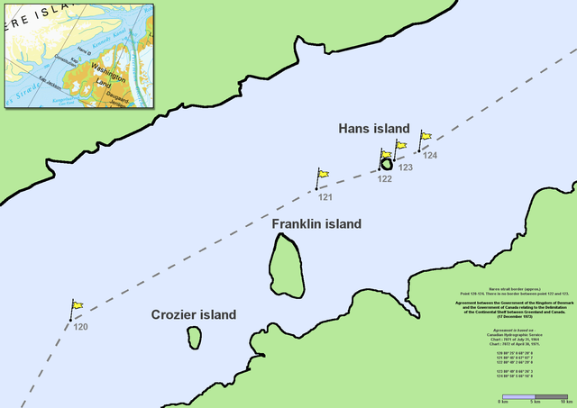
en:Nares Strait (en:Kennedy Channel) border (approx.) Point 120–124. There is no border between point 122 and 123. Agreement between the Government of the Kingdom of Denmark and the Government of Canada relating to the Delimitation of the Continental Shelf between Greenland and Canada. (17 December 1973) Agreement is based on en:Canadian Hydrographic Service charts 7071 of July 31, 1964 and 7072 of April 30, 1971
|
| Data | Commons upload by File Upload Bot (Magnus Manske) 10:54, 7 June 2006 (UTC) |
| Źródło |
Ten plik udostępniony jest na licencji Creative Commons Uznanie autorstwa 2.5.
|
| Autor | User Twthmoses on en.wikipedia |
Originally from en.wikipedia; description page is (was) here
.png)
- 06:02, 29 July 2005 Twthmoses 1765x1249 (196,934 bytes) ([[:en:Nares strait]] border (approx.) Point 120-124. There is no border between point 122 and 123. ''Agreement between the Government of the Kingdom of Denmark and the Government of Canada relating to the Delimitation of the Continental Shelf between Greenla)
Historia pliku
Kliknij na datę/czas, aby zobaczyć, jak plik wyglądał w tym czasie.
| Data i czas | Miniatura | Wymiary | Użytkownik | Opis | |
|---|---|---|---|---|---|
| aktualny | 12:32, 24 mar 2015 | | 1765 × 1249 (124 KB) | RokerHRO | optipng -o7 -i0 → 35.36% decrease |
| 12:54, 7 cze 2006 |  | 1765 × 1249 (192 KB) | File Upload Bot (Magnus Manske) | {{Information| |Description= en:Nares Strait (en:Kennedy Channel) border (approx.) Point 120-124. There is no border between point 122 and 123. ''Agreement between the Government of the Kingdom of Denmark and the Government of Canada relating |
Lokalne wykorzystanie pliku
Poniższa strona korzysta z tego pliku:
Globalne wykorzystanie pliku
Ten plik jest wykorzystywany także w innych projektach wiki:
- Wykorzystanie na ar.wikipedia.org
- Wykorzystanie na az.wikipedia.org
- Wykorzystanie na bcl.wikipedia.org
- Wykorzystanie na be-tarask.wikipedia.org
- Wykorzystanie na be.wikipedia.org
- Wykorzystanie na bn.wikipedia.org
- Wykorzystanie na ca.wikipedia.org
- Wykorzystanie na ceb.wikipedia.org
- Wykorzystanie na cs.wikipedia.org
- Wykorzystanie na da.wikipedia.org
- Wykorzystanie na de.wikipedia.org
- Wykorzystanie na en.wikipedia.org
- Wykorzystanie na en.wikiversity.org
- Wykorzystanie na eo.wikipedia.org
- Wykorzystanie na es.wikipedia.org
- Wykorzystanie na et.wikipedia.org
- Wykorzystanie na fa.wikipedia.org
- Wykorzystanie na fr.wikipedia.org
- Wykorzystanie na fy.wikipedia.org
- Wykorzystanie na he.wikipedia.org
Pokaż listę globalnego wykorzystania tego pliku.
.png)
.png)