Plik:Oberschlesien 1921.png
Grafika w wyższej rozdzielczości nie jest dostępna.
Oberschlesien_1921.png (411 × 323 pikseli, rozmiar pliku: 13 KB, typ MIME: image/png)
| Plik Oberschlesien 1921.png znajduje się w Wikimedia Commons – repozytorium wolnych zasobów. Dane z jego strony opisu znajdują się poniżej. |
Opis
| Opis |
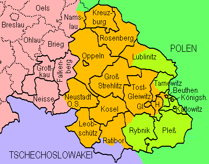
English: Upper Silesia plebiscite 1921: Lined borders = the German border of 1918 and districts of upper Silesia; dotted = Districts of lower Silesia; lilac = Czechoslovakia inclusive territories received from Germany without plebiscite; green = Poland; yellowish green = transferred to Poland after the plebiscite; orange = remaining in Germany after the plebiscite
Deutsch: Volksabstimmung in Oberschlesien 1921: Durchgezogene Grenzen = Reichsgrenze von 1918 und oberschlesische Kreise; gepunktete Grenzen = niederschlesische Kreise. Lila = Tschechoslowakei einschl. von Deutschland erhaltenem Gebiet; grün = Polen; gelbgrün = aufgrund der Abstimmung an Polen gekommenes Gebiet; orange = aufgrund der Abstimmung bei Deutschland gebliebenes Gebiet. Die Markierung der Teilungsgrenze(n) erfolgte anhand Westermanns Monatshefte-Atlas (ca. 1960, "aktuelle" Karte in der damals üblichen retro-Darstellung). Die Darstellung von Kreisen, die nur teilweise zum Abstimmungegebiet gehörten, erfolgte anhand in Berichten genannter Ortsnamen. |
| Data | |
| Źródło | Praca własna, redrawn from http://www.gemeindeverzeichnis.de/gem1900/gem1900.htm?gem1900_2.htm , where it is no more available |
| Autor | Ulamm |
Licencja
Ja, właściciel praw autorskich do tego dzieła, udostępniam je na poniższej licencji
Ten plik udostępniony jest na licencji Creative Commons Uznanie autorstwa 3.0.
- Wolno:
- dzielić się – kopiować, rozpowszechniać, odtwarzać i wykonywać utwór
- modyfikować – tworzyć utwory zależne
- Na następujących warunkach:
- uznanie autorstwa – musisz określić autorstwo utworu, podać link do licencji, a także wskazać czy utwór został zmieniony. Możesz to zrobić w każdy rozsądny sposób, o ile nie będzie to sugerować, że licencjodawca popiera Ciebie lub Twoje użycie utworu.
Historia pliku
Kliknij na datę/czas, aby zobaczyć, jak plik wyglądał w tym czasie.
| Data i czas | Miniatura | Wymiary | Użytkownik | Opis | |
|---|---|---|---|---|---|
| aktualny | 16:18, 7 sie 2009 | | 411 × 323 (13 KB) | Ulamm | Division of Kreis Lublinitz |
| 00:16, 13 wrz 2008 |  | 411 × 323 (13 KB) | Ulamm | {{Information |Description= |Source= |Date= |Author= |Permission= |other_versions= }} | |
| 22:39, 12 wrz 2008 |  | 411 × 330 (13 KB) | Ulamm | {{Information |Description={{en|1=Upper Silesia plebiscite 1921: Lined borders = the German border of 1918 and districts of upper Silesia; dotted = Districts of lower Silesia; lilac = Czechoslovakia inclusive territories received from Germany without pleb |
Lokalne wykorzystanie pliku
Poniższa strona korzysta z tego pliku:
Globalne wykorzystanie pliku
Ten plik jest wykorzystywany także w innych projektach wiki:
- Wykorzystanie na ar.wikipedia.org
- Wykorzystanie na cs.wikipedia.org
- Wykorzystanie na de.wikipedia.org
- Wykorzystanie na el.wikipedia.org
- Wykorzystanie na en.wikipedia.org
- Wykorzystanie na fi.wikipedia.org
- Wykorzystanie na fr.wikipedia.org
- Wykorzystanie na hu.wikipedia.org
- Wykorzystanie na id.wikipedia.org
- Wykorzystanie na incubator.wikimedia.org
- Wykorzystanie na it.wikipedia.org
- Wykorzystanie na nl.wikipedia.org
- Wykorzystanie na ru.wikipedia.org
- Wykorzystanie na th.wikipedia.org
- Wykorzystanie na tr.wikipedia.org
- Wykorzystanie na zh.wikipedia.org