Rozmiar pierwotny(1256 × 656 pikseli, rozmiar pliku: 75 KB, typ MIME: image/png)

Opis

Ta grafika (map) (lub wszystkie grafiki w tym artykule bądź kategorii) powinny zostać przetworzone na grafiki wektorowe jako plik SVG. O zaletach grafik wektorowych można przeczytać na stronie Commons:Media for cleanup. Jeśli wersja SVG tej grafiki jest już dostępna, załaduj ją. Po załadowaniu SVG zamień ten szablon na stronie tej grafiki na szablon {{vector version available|nazwa nowej grafiki.svg}}.
Opis
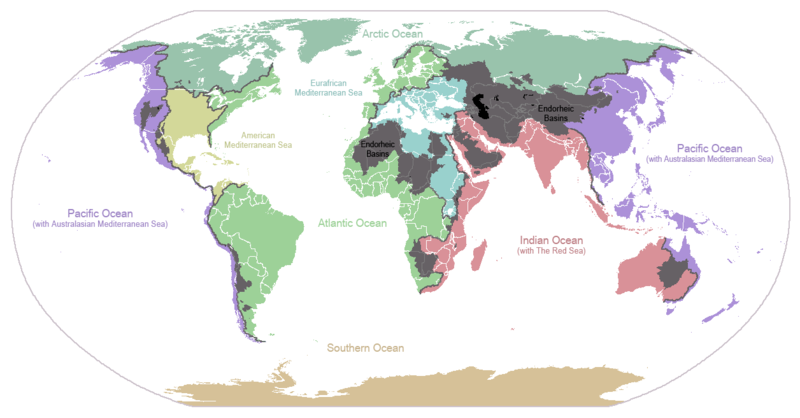
English: I made this map and hereby release it into the public domain. It shows the drainage basins for the major oceans and seas; grey areas are endorheic basins that do not drain to the ocean. Data is from the USGS Hydro1k project; information for Saskatchewan corrected by information from the Commission for Environmental Cooperation -- Citynoise
Description in large font size is used for oceans, in smaller font size is used for mediterranean seas. Only these mediterranean seas are listed which correspond to the definition of german Geographer Ernst Neef: A mediterranean sea is a sea between two Continents. Also found here: de:Mittelmeer --W like wiki (talk) 00:55, 12 March 2011 (UTC)
Français : Carte du monde des bassins versants. Les zones de couleur anthracite représentent les bassins endoréiques, qui ne sont reliés à aucun océan.
Čeština: Úmoří světových oceánů, popř. významných moří či zálivů. Legenda úmoří: fialová - Tichý oceán, růžová - Indický oceán, zelená - Atlantický oceán, azurová - Severní ledový oceán, béžová - Jižní oceán, modrá - Mexický záliv, světle modrá - Středozemní moře, šedá - oblast neústící ve světovém oceánu
Data 24 stycznia 2007 (data pierwszego przesłania pliku)
Źródło Na Commons przeniesiono z en.wikipedia.
Autor Citynoise z angielskiej Wikipedii
Inne wersje File:Major endorheic basins.png

Licencja

Public domain Ten utwór został udostępniony jako własność publiczna przez jego autora, Citynoise z angielskiej Wikipedii. Dotyczy to całego świata.
W niektórych krajach może nie być to prawnie możliwe, jeśli tak, to:
Citynoise zapewnia każdemu prawo do użycia tej pracy w dowolnym celu, bez żadnych ograniczeń, chyba że te ograniczenia są wymagane przez prawo.

Oryginalny rejestr przesyłania

Oryginalna strona opisu była tutaj. Wszystkie poniższe nazwy użytkowników odwołują się do en.wikipedia.
  • 2007-05-20 17:59 Bolonium 1256×656×8 (50194 bytes) I made this map and hereby release it into the public domain. It shows the drainage basins for the major oceans and seas; grey areas are endorheic basins that do not drain to the ocean. -- [[User:Citynoise|Citynoise]] == Licensing == {{self
  • 2007-01-24 07:21 Citynoise 1256×656×8 (63359 bytes) I made this map and hereby release it into the public domain. It shows the drainage basins for the major oceans and seas; grey areas are endorheic basins that do not drain to the ocean.
  • 2007-01-24 06:09 Citynoise 1256×656×8 (57358 bytes) I made this map and hereby release it into the public domain. It shows the drainage basins for the major oceans and seas; grey areas are endorheic basins that do not drain to the ocean.
  • 2007-01-24 05:10 Citynoise 1256×656×8 (56360 bytes) I made this map and hereby release it into the public domain. It shows the drainage basins for the major oceans and seas; grey areas are endorheic basins that do not drain to the ocean.
  • 2007-01-24 04:55 Citynoise 1256×656×8 (56373 bytes) I made this map and hereby release it into the public domain. It shows the drainage basins for the major oceans and seas; grey areas are endorheic basins that do not drain to the ocean.

Podpisy

Dodaj jednolinijkowe objaśnienie tego, co ten plik pokazuje
Drainage basins of the world, colored by ocean outlet. Endorheic basins not draining to an ocean are colored dark gray. Continental divides are indicated by dark lines.

Obiekty przedstawione na tym zdjęciu

przedstawia

Historia pliku

Kliknij na datę/czas, aby zobaczyć, jak plik wyglądał w tym czasie.

Data i czasMiniaturaWymiaryUżytkownikOpis
aktualny01:25, 7 paź 2015Miniatura wersji z 01:25, 7 paź 20151256 × 656 (75 KB)AcidSnowFixed Somalia.
02:39, 12 mar 2011Miniatura wersji z 02:39, 12 mar 20111256 × 656 (76 KB)W like wikiInsert Description. Big font size is used for oceans, smaller font size is used for mediterranean seas.
13:13, 30 cze 2009Miniatura wersji z 13:13, 30 cze 20091256 × 656 (40 KB)U7vGuntransparentize background,improve some details.
22:45, 26 lip 2008Miniatura wersji z 22:45, 26 lip 20081256 × 656 (62 KB)Citynoise{{Information |Description=added endorheic basins in Saskatchewan. |Source=my own work |Date=July 2008 |Author=Citynoise |Permission=all rights released |other_versions= }}
21:46, 27 lis 2007Miniatura wersji z 21:46, 27 lis 20071256 × 656 (49 KB)File Upload Bot (Magnus Manske) {{BotMoveToCommons|en.wikipedia}} {{Information |Description={{en|I made this map and hereby release it into the public domain. It shows the drainage basins for the major oceans and seas; grey areas are en:endorheic basins that do not drain to the

Poniższa strona korzysta z tego pliku:

Globalne wykorzystanie pliku

Ten plik jest wykorzystywany także w innych projektach wiki:

Pokaż listę globalnego wykorzystania tego pliku.

Metadane