Plik:Parthia 001ad.jpg
Rozmiar pierwotny (793 × 652 pikseli, rozmiar pliku: 741 KB, typ MIME: image/jpeg)
| Plik Parthia 001ad.jpg znajduje się w Wikimedia Commons – repozytorium wolnych zasobów. Dane z jego strony opisu znajdują się poniżej. |

|
Ta grafika (historical map) (lub wszystkie grafiki w tym artykule bądź kategorii) powinny zostać przetworzone na grafiki wektorowe jako plik SVG. O zaletach grafik wektorowych można przeczytać na stronie Commons:Media for cleanup. Jeśli wersja SVG tej grafiki jest już dostępna, załaduj ją. Po załadowaniu SVG zamień ten szablon na stronie tej grafiki na szablon {{vector version available|nazwa nowej grafiki.svg}}.
|


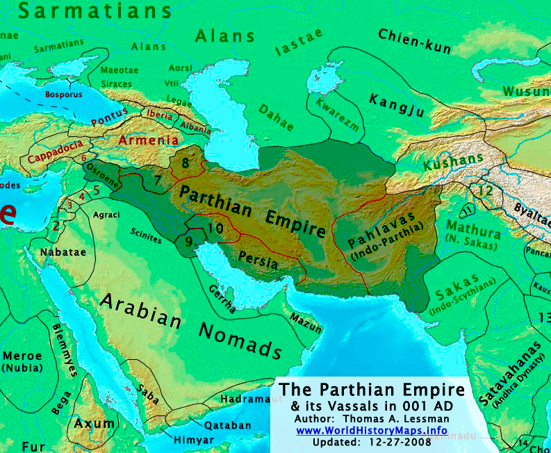
| Opis | The Parthian Empire in 001 AD. |
| Data | |
| Źródło | Praca własna; derived from (1) John Nelson. Interactive Historical Atlas of the World. Map of "Countries of the World 1/1/001 CE" and (2) Encyclopaedia Iranica, their article about the Parthians. |
| Autor | Thomas Lessman (Contact!) |
| Licencja (Ponowne użycie tego pliku) |
Ten plik udostępniony jest na licencji Creative Commons Uznanie autorstwa 3.0.
|
| Inne wersje | see below, العربيَّة |
Map Summary

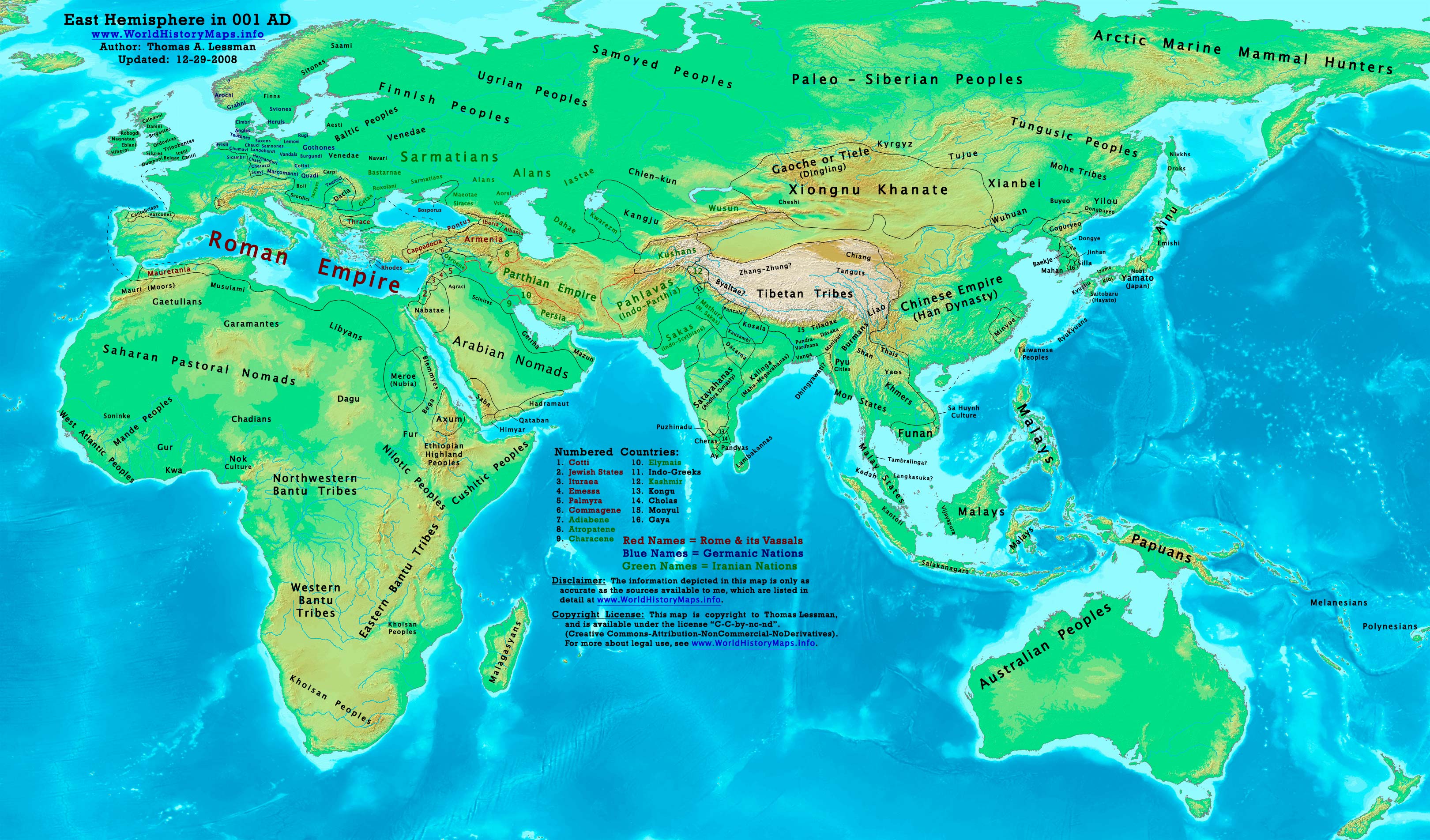
Original Source URL: http://www.worldhistorymaps.info/images/East-Hem_001ad.jpg
This map is a zoomed-in version of Thomas Lessman's map of the
East-Hem_001ad.jpg (also available at www.WorldHistoryMaps.info).
The highlighted areas represent the Parthian Empire and its vassal kingdoms in the year 1 AD.
Map Source References
Remember, sources often conflict with each other. This map is only as accurate as the information that is available to me. To report any errors or to help further this work, please click here, or email Thomas Lessman at talessman@yis.us
References for information contained in this map:
Other Maps by Thomas Lessman
| Maps of the eastern hemisphere showing history
Bold dates are available on Wikimedia or Wikipedia. | ||
| Primeval | ||
| Ancient
|
·| 600 BC | 550 BC | 527 BC | 500 BC |
400 BC | ·| 1 AD | 50 AD | 100 AD | 200 AD | 300 AD | | |
| Medieval |
·| 500 AD | 565 AD | 600 AD | 700 AD | | |
| Modern |
·| 1500 AD | · * For historical maps of the whole world, | |
Other Info
Historia pliku
Kliknij na datę/czas, aby zobaczyć, jak plik wyglądał w tym czasie.
| Data i czas | Miniatura | Wymiary | Użytkownik | Opis | |
|---|---|---|---|---|---|
| aktualny | 04:09, 29 gru 2008 | | 793 × 652 (741 KB) | Talessman | Category:Maps of the history of Iran |
| 23:37, 16 maj 2008 |  | 1025 × 677 (771 KB) | Talessman | Improved border appearance, corrected eastern borders of Parthia, other corrections explained on the [http://commons.wikimedia.org/wiki/Image:East-Hem_001ad.jpg East-Hem_001ad.jpg] description page. | |
| 00:51, 10 maj 2008 |  | 1022 × 854 (286 KB) | Talessman | {{Information |Description='''<big>The [http://en.wikipedia.org/wiki/Parthian_Empire Parthian Empire] in 001 AD.'''</big> |Source=Self-made |Author=Thomas Lessman (Contact!) |Permission={{self|cc-by-sa-3.0}} }} |
Lokalne wykorzystanie pliku
Poniższa strona korzysta z tego pliku:
Globalne wykorzystanie pliku
Ten plik jest wykorzystywany także w innych projektach wiki:
- Wykorzystanie na af.wikipedia.org
- Wykorzystanie na an.wikipedia.org
- Wykorzystanie na ar.wikipedia.org
- Wykorzystanie na av.wikipedia.org
- Wykorzystanie na azb.wikipedia.org
- Wykorzystanie na az.wikipedia.org
- Wykorzystanie na ba.wikipedia.org
- Wykorzystanie na be.wikipedia.org
- Wykorzystanie na bg.wikipedia.org
- Wykorzystanie na ca.wikipedia.org
- Wykorzystanie na ceb.wikipedia.org
- Wykorzystanie na ckb.wikipedia.org
- Wykorzystanie na cs.wikipedia.org
- Wykorzystanie na da.wikipedia.org
- Wykorzystanie na de.wikipedia.org
- Wykorzystanie na el.wikipedia.org
- Wykorzystanie na en.wikipedia.org
- Wykorzystanie na es.wikipedia.org
- Wykorzystanie na fa.wikipedia.org
- Wykorzystanie na fr.wikipedia.org
Pokaż listę globalnego wykorzystania tego pliku.