Plik:Port Phillip Bay.png
Grafika w wyższej rozdzielczości nie jest dostępna.
Port_Phillip_Bay.png (768 × 523 pikseli, rozmiar pliku: 897 KB, typ MIME: image/png)
| Plik Port Phillip Bay.png znajduje się w Wikimedia Commons – repozytorium wolnych zasobów. Dane z jego strony opisu znajdują się poniżej. |
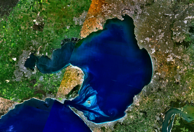
w:Port Phillip Bay, Australia. Melbourne is visible at the head of the bay, Geelong at the head of the western arm, Corio Bay.
| This image is in the public domain because it is a screenshot from NASA’s globe software World Wind using a public domain layer, such as Blue Marble, MODIS, Landsat, SRTM, USGS or GLOBE.
|
 |
Historia pliku
Kliknij na datę/czas, aby zobaczyć, jak plik wyglądał w tym czasie.
| Data i czas | Miniatura | Wymiary | Użytkownik | Opis | |
|---|---|---|---|---|---|
| aktualny | 23:56, 28 gru 2005 | | 768 × 523 (897 KB) | Stephen Bain | w:Port Phillip Bay, Australia. Melbourne is visible at the head of the bay, Geelong at the head of the western arm, Corio Bay. {{PD-WorldWind}} |
Lokalne wykorzystanie pliku
Poniższa strona korzysta z tego pliku:
Globalne wykorzystanie pliku
Ten plik jest wykorzystywany także w innych projektach wiki:
- Wykorzystanie na ar.wikipedia.org
- Wykorzystanie na be-tarask.wikipedia.org
- Wykorzystanie na be.wikipedia.org
- Wykorzystanie na ceb.wikipedia.org
- Wykorzystanie na en.wikipedia.org
- Wykorzystanie na en.wikivoyage.org
- Wykorzystanie na es.wikipedia.org
- Wykorzystanie na fi.wikipedia.org
- Wykorzystanie na fr.wikipedia.org
- Wykorzystanie na ga.wikipedia.org
- Wykorzystanie na gl.wikipedia.org
- Wykorzystanie na he.wikipedia.org
- Wykorzystanie na he.wikivoyage.org
- Wykorzystanie na it.wikipedia.org
- Wykorzystanie na it.wiktionary.org
- Wykorzystanie na ja.wikipedia.org
- Wykorzystanie na lt.wikipedia.org
- Wykorzystanie na pt.wikipedia.org
- Wykorzystanie na ru.wikipedia.org
- Wykorzystanie na simple.wikipedia.org
- Wykorzystanie na sv.wikipedia.org
- Wykorzystanie na uk.wikipedia.org
- Wykorzystanie na www.wikidata.org