Plik:Saxony locator map (1000).svg

Wielkość pliku podglądu PNG dla pliku SVG: 686 × 600 pikseli Inne rozdzielczości: 275 × 240 pikseli | 549 × 480 pikseli | 878 × 768 pikseli | 1171 × 1024 pikseli | 2342 × 2048 pikseli | 4431 × 3875 pikseli.
Rozmiar pierwotny (Plik SVG, nominalnie 4431 × 3875 pikseli, rozmiar pliku: 4,7 MB)
| Plik Saxony locator map (1000).svg znajduje się w Wikimedia Commons – repozytorium wolnych zasobów. Dane z jego strony opisu znajdują się poniżej. |
Opis
Ta ^specifik^ z W3C grafika wektorowa została stworzona za pomocą Inkscape .
| Opis |
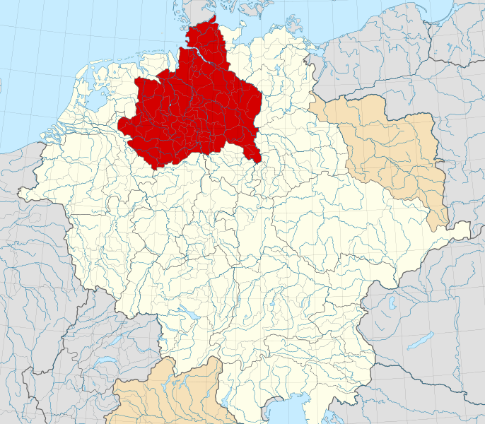
English: A map of the Duchy of Saxony (German: Herzogtum Sachsen) around 1000 CE.
The map is derived from a vectorised version of one found in Professor G. Droysens Allgemeiner Historischer Handatlas, which was published in 1886 by R. Andrée Plate, and is now in the public domain. Note that while it uses the same scheme as standard location/locator maps, this map technically does not conform to the standard, as it is not in equirectangular projection. Therefore grid lines for latitude and longitude are also included on the sub-map. |
| Data | |
| Źródło |
File: own work Data: File:Droysens-22-23.jpg |
| Autor | Alphathon /ˈæɫfə.θɒn/ (talk) |
| Inne wersje |
|
.svg)
.svg)
.svg)
.svg)

.svg)
.svg)
.svg)
Licencja
Ten plik udostępniony jest na licencji Creative Commons Uznanie autorstwa – Na tych samych warunkach 4.0 Międzynarodowe.
- Wolno:
- dzielić się – kopiować, rozpowszechniać, odtwarzać i wykonywać utwór
- modyfikować – tworzyć utwory zależne
- Na następujących warunkach:
- uznanie autorstwa – musisz określić autorstwo utworu, podać link do licencji, a także wskazać czy utwór został zmieniony. Możesz to zrobić w każdy rozsądny sposób, o ile nie będzie to sugerować, że licencjodawca popiera Ciebie lub Twoje użycie utworu.
- na tych samych warunkach – Jeśli zmienia się lub przekształca niniejszy utwór, lub tworzy inny na jego podstawie, można rozpowszechniać powstały w ten sposób nowy utwór tylko na podstawie tej samej lub podobnej licencji.
Historia pliku
Kliknij na datę/czas, aby zobaczyć, jak plik wyglądał w tym czasie.
| Data i czas | Miniatura | Wymiary | Użytkownik | Opis | |
|---|---|---|---|---|---|
| aktualny | 18:15, 22 maj 2016 | | 4431 × 3875 (4,7 MB) | Alphathon | Changed colour of the Kingdom of Italy to reflect its inclusion in the Holy Roman Empire. Changed the colour of Silesian tributaries so as the not imply it was part of the Kingdom. Also changed colour of Rügen since it was neither in the Empire nor th... |
| 04:26, 18 maj 2016 |  | 4431 × 3875 (4,7 MB) | Alphathon | == {{int:filedesc}} == {{Inkscape}} {{Information |Description={{en|A map of the en:Duchy of Saxony (German: ''Herzogtum Sachsen'') around 1000 CE. The map is derived from a vectorised version of one found in Professor G. Droysens Allgem... |
Lokalne wykorzystanie pliku
Następujące strony korzystają z tego pliku:
Globalne wykorzystanie pliku
Ten plik jest wykorzystywany także w innych projektach wiki:
- Wykorzystanie na ar.wikipedia.org
- Wykorzystanie na ast.wikipedia.org
- Wykorzystanie na azb.wikipedia.org
- Wykorzystanie na be.wikipedia.org
- Wykorzystanie na bg.wikipedia.org
- Wykorzystanie na ca.wikipedia.org
- Wykorzystanie na cs.wikipedia.org
- Wykorzystanie na de.wikipedia.org
- Wykorzystanie na el.wikipedia.org
- Wykorzystanie na en.wikipedia.org
- Wykorzystanie na es.wikipedia.org
- Wykorzystanie na et.wikipedia.org
- Wykorzystanie na fa.wikipedia.org
- Wykorzystanie na fr.wikipedia.org
- Wykorzystanie na fy.wikipedia.org
- Wykorzystanie na ga.wikipedia.org
- Wykorzystanie na it.wikipedia.org
- Wykorzystanie na ja.wikipedia.org
- Wykorzystanie na ko.wikipedia.org
- Wykorzystanie na mk.wikipedia.org
- Wykorzystanie na pl.wiktionary.org
- Wykorzystanie na th.wikipedia.org
- Wykorzystanie na tr.wikipedia.org
- Wykorzystanie na vi.wikipedia.org
- Wykorzystanie na www.wikidata.org
- Wykorzystanie na zh.wikipedia.org
.svg)