Plik:USA Territorial Growth 1850.jpg

Rozmiar pierwotny (1400 × 616 pikseli, rozmiar pliku: 124 KB, typ MIME: image/jpeg)
| Plik USA Territorial Growth 1850.jpg znajduje się w Wikimedia Commons – repozytorium wolnych zasobów. Dane z jego strony opisu znajdują się poniżej. |
| US growth maps |
| Animated: large · small |
| Years |
| 1775 · 1790 · 1800 · 1810 · 1820 · 1830 · 1840 · 1850 · 1860 · 1870 · 1880 · 1900 · 1920 |
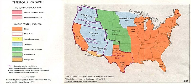
Map of U.S. Territorial Growth (1850) from the Perry-Castañeda Library Map Collection, "...the maps scanned by the University of Texas Libraries and served from this web site are in the public domain. No permissions are needed to copy them. You may download them and use them as you wish."
This image can be found at U.S. Territorial Growth 1850.
"Courtesy of the University of Texas Libraries, The University of Texas at Austin."
Other versions: 
|
Ten materiał przeszedł do domeny publicznej w kraju pochodzenia, jak również w państwach i terytoriach, gdzie prawo autorskie wygasa w ciągu 70 lat po śmierci autora.
| |
| Plik rozpoznano jako wolny od znanych ograniczeń praw autorskich, włącznie z prawami zależnymi i pokrewnymi. | |
Historia pliku
Kliknij na datę/czas, aby zobaczyć, jak plik wyglądał w tym czasie.
| Data i czas | Miniatura | Wymiary | Użytkownik | Opis | |
|---|---|---|---|---|---|
| aktualny | 08:18, 4 paź 2005 | | 1400 × 616 (124 KB) | Lordkinbote~commonswiki | Map of U.S. Territorial Growth (1850) from the Perry-Castañeda Library Map Collection. This image can be found at [http://www.lib.utexas.edu/maps/united_states/us_terr_1850.jpg]. |
Lokalne wykorzystanie pliku
Poniższa strona korzysta z tego pliku:
Globalne wykorzystanie pliku
Ten plik jest wykorzystywany także w innych projektach wiki:
- Wykorzystanie na ca.wikipedia.org
- Wykorzystanie na de.wikipedia.org
- Wykorzystanie na en.wikipedia.org
- Wykorzystanie na es.wikinews.org
- Wykorzystanie na hy.wikipedia.org
- Wykorzystanie na it.wikipedia.org
- Wykorzystanie na ja.wikipedia.org
- Wykorzystanie na la.wikipedia.org
- Wykorzystanie na nl.wikipedia.org
- Wykorzystanie na no.wikipedia.org
- Wykorzystanie na pt.wikipedia.org
- Wykorzystanie na ro.wikipedia.org
- Wykorzystanie na ru.wikipedia.org
- Wykorzystanie na simple.wikipedia.org
- Wykorzystanie na uk.wikipedia.org