Plik:1918. Карта УНР.jpg

Rozmiar podglądu – 800 × 535 pikseli. Inne rozdzielczości: 320 × 214 pikseli | 640 × 428 pikseli | 1024 × 684 pikseli | 1280 × 855 pikseli | 2560 × 1711 pikseli | 3104 × 2074 pikseli.
Rozmiar pierwotny (3104 × 2074 pikseli, rozmiar pliku: 3,16 MB, typ MIME: image/jpeg)
| Plik 1918. Карта УНР.jpg znajduje się w Wikimedia Commons – repozytorium wolnych zasobów. Dane z jego strony opisu znajdują się poniżej. |
Opis
| Opis |
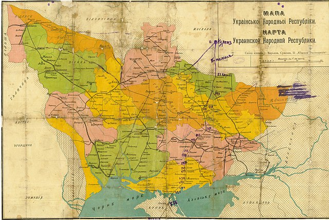
Русский: Карта УНР
Українська: Мапа зберігалася в родинному архіві сім'ї Голубченків у Сумах. У серпні 2005 року сім'я передала карту на зберігання до Державного архіву Сумської області.
English: Map of the UPR. The map was kept in the family archive of the Golubchenko family in Sumy. In August 2005, the family transferred the map to the State Archives of the Sumy Region for safekeeping. |
|||
| Data | ||||
| Źródło | ||||
| Autor |
Русский: Южная экспедиция |
|||
| Licencja (Ponowne użycie tego pliku) |
|

Historia pliku
Kliknij na datę/czas, aby zobaczyć, jak plik wyglądał w tym czasie.
| Data i czas | Miniatura | Wymiary | Użytkownik | Opis | |
|---|---|---|---|---|---|
| aktualny | 12:19, 8 kwi 2014 | | 3104 × 2074 (3,16 MB) | Butko | {{Information |Description={{ru|Карта УНР}} |Source= * http://img-fotki.yandex.ru/get/9809/18675158.6b/0_102b44_19e71493_orig * http://hai-nyzhnyk.in.ua/doc2/map.unr.php |Date=1918 |Author={{ru|Южная экспедиция}} |Permission={{PD... |
Lokalne wykorzystanie pliku
Żadna strona nie korzysta z tego pliku.
Globalne wykorzystanie pliku
Ten plik jest wykorzystywany także w innych projektach wiki:
- Wykorzystanie na en.wikipedia.org
- Wykorzystanie na es.wikipedia.org
- Wykorzystanie na it.wikipedia.org
- Wykorzystanie na lv.wikipedia.org
- Wykorzystanie na ru.wikipedia.org
- Украинская Советская Социалистическая Республика
- Раздельная
- Украинская Народная Республика
- Украинская Центральная рада
- Революция и Гражданская война на Украине
- Южный революционный фронт по борьбе с контрреволюцией (1917)
- Бои за Донбасс (январь — май 1919)
- Википедия:К переименованию/8 декабря 2015
- Участник:ASDFS/Черновик
- Википедия:Сообщения об ошибках/Архив/2023/07
- История административно-территориального устройства Украины
- Wykorzystanie na uk.wikipedia.org