Plik:Alignment Official Pakistan map 1962.jpg
Rozmiar pierwotny (600 × 616 pikseli, rozmiar pliku: 59 KB, typ MIME: image/jpeg)
| Plik Alignment Official Pakistan map 1962.jpg znajduje się w Wikimedia Commons – repozytorium wolnych zasobów. Dane z jego strony opisu znajdują się poniżej. |
Opis

|
Ta grafika (historical map) (lub wszystkie grafiki w tym artykule bądź kategorii) powinny zostać przetworzone na grafiki wektorowe jako plik SVG. O zaletach grafik wektorowych można przeczytać na stronie Commons:Media for cleanup. Jeśli wersja SVG tej grafiki jest już dostępna, załaduj ją. Po załadowaniu SVG zamień ten szablon na stronie tej grafiki na szablon {{vector version available|nazwa nowej grafiki.svg}}.
|


| Opis |
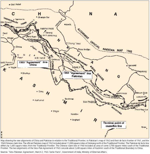
English: Map depicting the official alignment of the northern border of Kashmir in 1962 according to the Government of Pakistan |
| Data | |
| Źródło | Sino Pakistan "Agreement", March 2, 1963 "Some facts" published by the Government of India, Ministry of External Affairs |
| Autor | The Government of India, Ministry of External Affairs |
| Pozycja fotografa | | To i inne zdjęcia na: OpenStreetMap |
|---|
The area pertains to the Cis-Kuen Lun Tract in northern Kashmir, the area in northern Kashmir which has been either annexed by the Chinese or is part of the area ceded by Pakistan to the Chinese. The Northern border of the Cis-Kuen Lun Tract is the area of Dafdar in the area of the Taghdumbash Pamir and Mariom Pamir and the mountain passes in northern Kashmir including inter alia the Kukalang Pass, Yangi Pass to the north of the Raskam area in Kanjut , the Kilian Pass, the Sanju-La Pass and the Hindutash Pass. The Government of Pakistan had published an official map depicting the alignment of the northern Border of Kashmir in 1962 which depicted much of the Cis-Kuen Lun Tract as part of Kashmir and the Times Atlas had predominantly depicted the Cis-Kuen Lun Tract as a part of Kashmir under the caption "Undefined Frontier area" in 1959.
Licencja
This work is in the public domain in India because its term of copyright has expired.
The Indian Copyright Act applies in India to works first published in India. According to the Indian Copyright Act, 1957, as amended up to Act No. 27 of 2012 (Chapter V, Section 25):
|
 |
– India public domain images and sounds, 60 years after the end of the year of first publication, The subject matter of the photo or recording is also not protected by copyright.
Historia pliku
Kliknij na datę/czas, aby zobaczyć, jak plik wyglądał w tym czasie.
| Data i czas | Miniatura | Wymiary | Użytkownik | Opis | |
|---|---|---|---|---|---|
| aktualny | 15:56, 21 kwi 2016 | | 600 × 616 (59 KB) | Hindutashravi | User created page with UploadWizard |
Lokalne wykorzystanie pliku
Poniższa strona korzysta z tego pliku:
Globalne wykorzystanie pliku
Ten plik jest wykorzystywany także w innych projektach wiki:
- Wykorzystanie na en.wikipedia.org
- Wykorzystanie na ja.wikipedia.org
- Wykorzystanie na te.wikipedia.org