Plik:Andorra relief location map.jpg

Rozmiar podglądu – 683 × 599 pikseli. Inne rozdzielczości: 274 × 240 pikseli | 547 × 480 pikseli | 875 × 768 pikseli | 1161 × 1019 pikseli.
Rozmiar pierwotny (1161 × 1019 pikseli, rozmiar pliku: 220 KB, typ MIME: image/jpeg)
| Plik Andorra relief location map.jpg znajduje się w Wikimedia Commons – repozytorium wolnych zasobów. Dane z jego strony opisu znajdują się poniżej. |
Opis
| Opis |
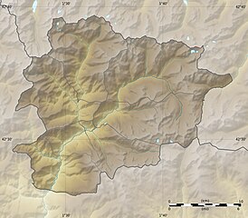
English: Blank physical map of Andorra with parishes boundaries for geo-location purpose.
Note: Dotted lines are boundaries estimated from very small scale reference maps. Français : Carte physique vierge de l'Andorre avec limites des paroisses destinée à la géolocalisation. Note : les lignes pointillées sont des limites estimées à partir de cartes de référence à très petite échelle. Equirectangular projection, WGS84 datum
Topographic scale: 1:372,000 (precision: 93 m)
|
||
| Data | |||
| Źródło |
Own work |
||
| Autor | Eric Gaba (Sting - fr:Sting) | ||
| Licencja (Ponowne użycie tego pliku) |
|
||
| Inne wersje |
|

| Pozycja fotografa | | To i inne zdjęcia na: OpenStreetMap |
|---|
Licencja
Ja, właściciel praw autorskich do tego dzieła, udostępniam je na poniższych licencjach
Ten plik udostępniony jest na licencji Creative Commons Uznanie autorstwa – Na tych samych warunkach 3.0.
- Wolno:
- dzielić się – kopiować, rozpowszechniać, odtwarzać i wykonywać utwór
- modyfikować – tworzyć utwory zależne
- Na następujących warunkach:
- uznanie autorstwa – musisz określić autorstwo utworu, podać link do licencji, a także wskazać czy utwór został zmieniony. Możesz to zrobić w każdy rozsądny sposób, o ile nie będzie to sugerować, że licencjodawca popiera Ciebie lub Twoje użycie utworu.
- na tych samych warunkach – Jeśli zmienia się lub przekształca niniejszy utwór, lub tworzy inny na jego podstawie, można rozpowszechniać powstały w ten sposób nowy utwór tylko na podstawie tej samej lub podobnej licencji.

|
Udziela się zgody na kopiowanie, rozpowszechnianie oraz modyfikowanie tego dokumentu zgodnie z warunkami GNU Licencji Wolnej Dokumentacji, w wersji 1.2 lub nowszej opublikowanej przez Free Software Foundation; bez niezmiennych sekcji, bez treści umieszczonych na frontowej lub tylnej stronie okładki. Kopia licencji załączona jest w sekcji zatytułowanej GNU Licencja Wolnej Dokumentacji. |
Możesz wybrać, którą licencję chcesz zastosować.
Historia pliku
Kliknij na datę/czas, aby zobaczyć, jak plik wyglądał w tym czasie.
| Data i czas | Miniatura | Wymiary | Użytkownik | Opis | |
|---|---|---|---|---|---|
| aktualny | 22:52, 27 gru 2010 | | 1161 × 1019 (220 KB) | Sting | Added parishes boundaries (some of them estimated) |
| 14:09, 19 lip 2010 |  | 1161 × 1019 (212 KB) | Sting | Color profile | |
| 22:04, 17 gru 2008 |  | 1161 × 1019 (181 KB) | Sting | Corrections on international boundaries | |
| 22:20, 16 gru 2008 |  | 1161 × 1019 (189 KB) | Sting | == Summary == {{Location|42|32|15|N|01|36|00|E|scale:200000}} <br/> {{Information |Description={{en|Blank physical map of Andorra for geo-location purpose.}} {{fr|Carte physique vierge de l'Andorre destinée à la géolocal |
Lokalne wykorzystanie pliku
Następujące strony korzystają z tego pliku:
- Alt de la Capa
- Alt del Griu
- Bony de les Neres
- Estanys de Juclar
- Montmalús
- Obaga de Nou Fonts
- Pic Alt del Cubil
- Pic Negre
- Pic Nègre d’Envalira
- Pic de Besalí
- Pic de Carroi
- Pic de Catavardis
- Pic de Coma Pedrosa
- Pic de Creussans
- Pic de Fangasses
- Pic de Font Blanca
- Pic de Meners
- Pic de Mil Menut
- Pic de Monturull
- Pic de Médécourbe
- Pic de Ransol
- Pic de Sanfonts
- Pic de Serrère
- Pic de Soulanet
- Pic de Tristagne
- Pic de la Coma de Varilles
- Pic de la Coume de Seignac
- Pic de la Portelleta
- Pic de les Fonts
- Pic de les Planes
- Pic de l’Angonella
- Pic de l’Estany Mort
- Pic de l’Estanyó
- Pic de l’Hortell
- Pic del Pla de l’Estany
- Pic del Port Vell
- Pic dels Estanyons
- Pic dels Llacs
- Pic dels Pessons
- Pic du Port de Siguer
- Pic du Sal
- Pic d’Aos
- Pic d’Arcalis
- Pic d’Arial
- Pics de Casamanya
- Punta de Peiraguils
- Roca Entravessada
- Torre dels Soldats
- Tossal Braibal
- Tossal de la Llosada
- Moduł:Mapa/dane/AND
- Moduł:Mapa/dane/Andora
Globalne wykorzystanie pliku
Ten plik jest wykorzystywany także w innych projektach wiki:
- Wykorzystanie na ar.wikipedia.org
- Wykorzystanie na ast.wikipedia.org
- Wykorzystanie na av.wikipedia.org
- Wykorzystanie na az.wikipedia.org
- Wykorzystanie na ba.wikipedia.org
- Wykorzystanie na be-tarask.wikipedia.org
- Wykorzystanie na be.wikipedia.org
- Wykorzystanie na bg.wikipedia.org
- Wykorzystanie na bn.wikipedia.org
- Wykorzystanie na bs.wikipedia.org
- Wykorzystanie na ca.wikipedia.org
- Usuari:PereBot/cobertura/Andorra relleu/ranking
- Usuari:PereBot/cobertura/Andorra relleu/an
- Usuari:PereBot/cobertura/Andorra relleu/ca
- Usuari:PereBot/cobertura/Andorra relleu/de
- Usuari:PereBot/cobertura/Andorra relleu/en
- Usuari:PereBot/cobertura/Andorra relleu/es
- Usuari:PereBot/cobertura/Andorra relleu/eu
- Usuari:PereBot/cobertura/Andorra relleu/fr
- Usuari:PereBot/cobertura/Andorra relleu/nl
- Usuari:PereBot/cobertura/Andorra relleu/it
- Usuari:PereBot/cobertura/Andorra relleu/oc
- Usuari:PereBot/cobertura/Andorra relleu/zh
- Usuari Discussió:Lanxana
- Mòdul:Location map/data/Andorra
- Mòdul:Location map/data/Andorra/ús
- Wykorzystanie na ceb.wikipedia.org
- Wykorzystanie na ce.wikipedia.org
- Wykorzystanie na ckb.wikipedia.org
- Wykorzystanie na cs.wikipedia.org
- Wykorzystanie na cv.wikipedia.org
- Wykorzystanie na da.wikipedia.org
- Wykorzystanie na de.wikipedia.org
Pokaż listę globalnego wykorzystania tego pliku.