Plik:Bonadelle Ranchos-Madera Ranchos, California (20952163403).jpg

Rozmiar pierwotny (4000 × 3000 pikseli, rozmiar pliku: 2,62 MB, typ MIME: image/jpeg)
| Plik Bonadelle Ranchos-Madera Ranchos, California (20952163403).jpg znajduje się w Wikimedia Commons – repozytorium wolnych zasobów. Dane z jego strony opisu znajdują się poniżej. |
.jpg)
Opis
| Opis |
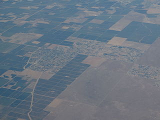
Bonadelle Ranchos-Madera Ranchos is a census-designated place (CDP) in Madera County, California, United States. It is part of the Madera–Chowchilla Metropolitan Statistical Area. The population was 8,569 at the 2010 census, up from 7,300 at the 2000 census. The Bonadelle Ranchos is often regarded as a Valley-Foothill transitional zone, because its elevation is higher than average for valley but slightly too low to be considered part of the Sierra foothills. Immediately Northeast lies the rugged foothills of the Sierra Nevada range. Its environment corresponds, showing qualities of a transition zone. The Northeast portion of the area is the highest in elevation,and small tabletop hills are present: most notably Adobe Hill, which lies at an elevation of 640 feet. All throughout the area, there is large, rolling hills. Multiple creeks run through the area, but none are large enough to bring constant flow. The creeks include Little Dry Creek, Bonadelle Creek, Cottonwood Creek, and Root Creek. Many of these waterways flow in the winter months, when rainfall and snow filter down from the nearby foothills. There are many seasonal ponds in the area, however most are too small and short-lived to offer recreational activities. Many of the wildlife is typical for this type of environment. Mammals include foxes, ground squirrels, coyotes, raccoons, skunks and occasionally bobcats and mountain lions. Dove, crows, ravens, ducks, Scrub jays, California woodpeckers, egrets, red tailed hawks, turkey vultures, and geese can be found as well. en.wikipedia.org/wiki/Bonadelle_Ranchos-Madera_Ranchos,_C... en.wikipedia.org/wiki/Wikipedia:Text_of_Creative_Commons_... |
| Data | |
| Źródło | Bonadelle Ranchos-Madera Ranchos, California |
| Autor | Ken Lund from Reno, Nevada, USA |
| Pozycja fotografa | | To i inne zdjęcia na: OpenStreetMap |
|---|
.jpg¶ms=037.041013_N_-119.595634_E_globe:Earth_type:camera_source:Flickr_&language=pl)
Licencja
- Wolno:
- dzielić się – kopiować, rozpowszechniać, odtwarzać i wykonywać utwór
- modyfikować – tworzyć utwory zależne
- Na następujących warunkach:
- uznanie autorstwa – musisz określić autorstwo utworu, podać link do licencji, a także wskazać czy utwór został zmieniony. Możesz to zrobić w każdy rozsądny sposób, o ile nie będzie to sugerować, że licencjodawca popiera Ciebie lub Twoje użycie utworu.
- na tych samych warunkach – Jeśli zmienia się lub przekształca niniejszy utwór, lub tworzy inny na jego podstawie, można rozpowszechniać powstały w ten sposób nowy utwór tylko na podstawie tej samej lub podobnej licencji.
| Ten plik, opublikowany pierwotnie w serwisie Flickr przez Ken Lund pod adresem https://flickr.com/photos/75683070@N00/20952163403, został sprawdzony 4 grudnia 2015 przez FlickreviewR, który potwierdził, że jest on tam dostępny na licencji cc-by-sa-2.0. |
Historia pliku
Kliknij na datę/czas, aby zobaczyć, jak plik wyglądał w tym czasie.
| Data i czas | Miniatura | Wymiary | Użytkownik | Opis | |
|---|---|---|---|---|---|
| aktualny | 06:50, 4 gru 2015 | | 4000 × 3000 (2,62 MB) | INeverCry | Transferred from Flickr via Flickr2Commons |
Lokalne wykorzystanie pliku
Poniższa strona korzysta z tego pliku:
Globalne wykorzystanie pliku
Ten plik jest wykorzystywany także w innych projektach wiki:
- Wykorzystanie na en.wikipedia.org
- Wykorzystanie na nv.wikipedia.org
- Wykorzystanie na simple.wikipedia.org
- Wykorzystanie na sr.wikipedia.org
- Wykorzystanie na uk.wikipedia.org
.jpg)