Plik:Boteti River, Botswana.jpg

Rozmiar pierwotny (2043 × 1407 pikseli, rozmiar pliku: 477 KB, typ MIME: image/jpeg)
| Plik Boteti River, Botswana.jpg znajduje się w Wikimedia Commons – repozytorium wolnych zasobów. Dane z jego strony opisu znajdują się poniżej. |
Opis
| Opis |
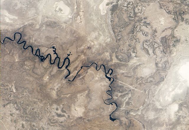
English: Natural-colour image of the Boteti River. Arising from overflow in the Okavango Delta, the Boteti River flows toward the south-east before turning northward into the expansive salt-pans of Makgadikgadi. This image shows the river stopping short of Makgadikgadi, which lies to the east.
The river follows a long series of hairpin curves. On the outer loops of some curves, the river overflows onto nearby floodplains. Two such overflows are obvious near the centre of the image. In the east, another area of overflow takes the approximate shape of a boot. Here the water has probably flowed onto agricultural fields, and the water’s spread may be constrained by a nearby road. Near the lower right corner of the image, the Boteti River terminates. Upstream from this endpoint, the river is particularly thin. The water supply may still be insufficient to drive the Boteti onward into the nearby saltpans. According to Frank Eckhardt of the University of Cape Town, the presence of any water in the river valley was unusual by 2010, and some observers thought the Boteti was a dead river. Naturalist blogs reported that the Boteti held some water in September 2009, but according to Eckardt, its last major flood occurred in 1991. Outside of the river valley, the dry season has parched the landscape. Nearby river valleys, floodplains, and salt lakes appear in tones of beige and brown.Afrikaans: Satellietbeeld in natuurlike kleur van die Botetirivier in Botswana. Die rivier ontvang water wat uit die Okawangodelta oorvloei na die suid-ooste, voordat dit noordwaarts draai na die uitgebreide Makgadikgadi-soutpanne. In hierdie beeld word die watervloei onderbreek voor dit die Makgadikgadi bereik, wat na die ooste lê.
Die rivier maak 'n langs reeks haarnaaldraaie, en spoel oor in aanliggende vloedvlaktes aan die buitekant van enkele van hierdie kurwes. Twee opvallende oorvloeie van hierdie aard is sigbaar naby die middel van die beeld, en na die ooste is 'n ander oorvloei sigbaar in die vorm van 'n stewel, waar die oorstroming waarskynlik landerye benat, en begrens word deur 'n nabye pad. Onder regs op die beeld loop die Botetirivier dood, en stroomop van hierdie eindpunt is die rivier besonder nou. Die watertoevoer is moontlik onvoldoende om die Boteti na die nabye soutpanne aan te dryf. Volgens Frank Eckhardt van die Universiteit van die Kaapstad was die teenwoordigheid van water in die riviervallei 'n ongewone verskynsel teen 2010, en enkele waarnemers was van mening dat die Boteti 'n dooie rivier was. Verslae op natuurblogs het aangedui dat die Boteti in September 2009 matig water gehou het, maar volgens Eckardt het die laaste beduidende vloed in 1991 voorgekom. Buite die riviervallei is die landskap uitgedor deur die droëseisoen, en aanliggende riviervalleie, vloedvlaktes en soutpanne is sigbaar in vaal en bruin skakerings. |
| Data | |
| Źródło | Image captured by the Advanced Land Imager (ALI) on NASA’s Earth Observing-1 (EO-1) satellite. EO-1 ALI data provided courtesy of the NASA EO-1 team and the United States Geological Survey. |
| Autor | Jesse Allen and Robert Simmon |
Licencja
| Ten plik jest w domenie publicznej ponieważ został stworzony przez NASA. Polityka praw autorskich NASA stwierdza, że „materiały NASA nie są chronione prawami autorskimi, chyba że zapisano inaczej”. (NASA copyright policy lub JPL Image Use Policy). | ||
 |
Uwaga:
|
Historia pliku
Kliknij na datę/czas, aby zobaczyć, jak plik wyglądał w tym czasie.
| Data i czas | Miniatura | Wymiary | Użytkownik | Opis | |
|---|---|---|---|---|---|
| aktualny | 14:13, 8 paź 2010 | | 2043 × 1407 (477 KB) | Originalwana | {{Information |Description={{en|1=Natural-colour image of the Boteti River. Arising from overflow in the Okavango Delta, the Boteti River flows toward the south-east before turning northward into the expansive salt-pans of [[: |
Lokalne wykorzystanie pliku
Poniższa strona korzysta z tego pliku:
Globalne wykorzystanie pliku
Ten plik jest wykorzystywany także w innych projektach wiki:
- Wykorzystanie na af.wikipedia.org
- Wykorzystanie na arz.wikipedia.org
- Wykorzystanie na ceb.wikipedia.org
- Wykorzystanie na de.wikipedia.org
- Wykorzystanie na en.wikipedia.org
- Wykorzystanie na eo.wikipedia.org
- Wykorzystanie na es.wikipedia.org
- Wykorzystanie na fa.wikipedia.org
- Wykorzystanie na fr.wikipedia.org
- Wykorzystanie na ha.wikipedia.org
- Wykorzystanie na ru.wikipedia.org
- Wykorzystanie na tn.wikipedia.org
- Wykorzystanie na www.wikidata.org
- Wykorzystanie na zh.wikipedia.org