Plik:Chugwater Soda Fountain.jpg

Rozmiar pierwotny (4000 × 3000 pikseli, rozmiar pliku: 2,66 MB, typ MIME: image/jpeg)
| Plik Chugwater Soda Fountain.jpg znajduje się w Wikimedia Commons – repozytorium wolnych zasobów. Dane z jego strony opisu znajdują się poniżej. |
Opis
| Opis |
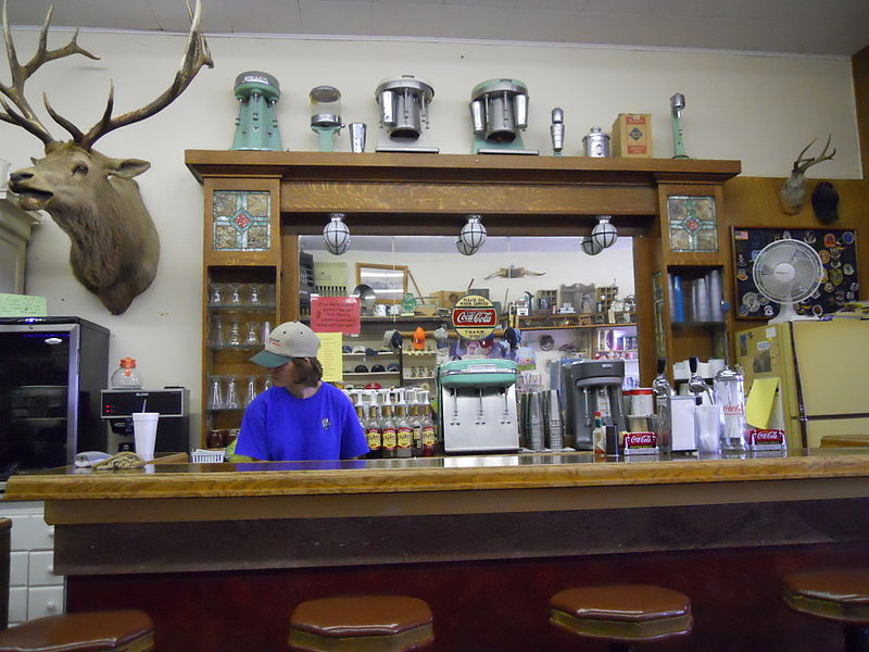
The History of the Chugwater Soda Fountain The Oldest Operating Soda fountain in Wyoming The Soda fountain is housed in one of the oldest buildings in Chugwater. The building was built in 1914, later, partially burned down, and was rebuilt in 1916. It has been a Doctor's office and a pharmacy. There was a small apartment in the back where the doctor and his family lived. The pharmacy drawers are still intact along one wall of the store. The soda fountain bar was built in England and installed in a business in Rock Creek WY. when the Railroad went through in 1927, the town moved to Tock River. The owner was not interested in moving his business, so he sold his equipment to the owner of the pharmacy in Chugwater. The bar was broken aprt into three pieces - the main bar, the top(including the mirror), and the bottom cabinets. It was then packed into wagons and transported over the mountains to be installed in this building. The mirror and glass are all original; you can stand in the back and see the curve in the mirror.1 The pharmacy and soda fountain co-existed for some time, but eventually one of the owners no longer had a pharmacy license and the store became a soda fountain only. Ownership has changed hands many times, with different people making various changes. The large elk overlooking the room is nicknamed "Wendall" for the man who shot him. He was shot near Jackson, WY in 1946 and has resided in the soda fountain since 1947. A town petition prevents Wendall from leaving, no matter who owns it. Over time, different owners have added components like the small package liquor store, "diner", and the Beer Garden in the summer. It remains one of few active soda fountains in the state that serves traditional, hand dipped ice cream shakes and malts. |
| Data | |
| Źródło | Chugwater Soda Fountain |
| Autor | Konrad Summers from Santa Clarita (Valencia) , California, USA |
| Pozycja fotografa | | To i inne zdjęcia na: OpenStreetMap |
|---|
Licencja
- Wolno:
- dzielić się – kopiować, rozpowszechniać, odtwarzać i wykonywać utwór
- modyfikować – tworzyć utwory zależne
- Na następujących warunkach:
- uznanie autorstwa – musisz określić autorstwo utworu, podać link do licencji, a także wskazać czy utwór został zmieniony. Możesz to zrobić w każdy rozsądny sposób, o ile nie będzie to sugerować, że licencjodawca popiera Ciebie lub Twoje użycie utworu.
- na tych samych warunkach – Jeśli zmienia się lub przekształca niniejszy utwór, lub tworzy inny na jego podstawie, można rozpowszechniać powstały w ten sposób nowy utwór tylko na podstawie tej samej lub podobnej licencji.
| Ten plik, opublikowany pierwotnie w serwisie Flickr przez tkksummers pod adresem https://www.flickr.com/photos/12806074@N08/4712851275, został sprawdzony 14 lipca 2015 przez FlickreviewR, który potwierdził, że jest on tam dostępny na licencji cc-by-sa-2.0. |
Historia pliku
Kliknij na datę/czas, aby zobaczyć, jak plik wyglądał w tym czasie.
| Data i czas | Miniatura | Wymiary | Użytkownik | Opis | |
|---|---|---|---|---|---|
| aktualny | 23:22, 14 lip 2015 | | 4000 × 3000 (2,66 MB) | Tillman | Transferred from Flickr via Flickr2Commons |
Lokalne wykorzystanie pliku
Żadna strona nie korzysta z tego pliku.
Globalne wykorzystanie pliku
Ten plik jest wykorzystywany także w innych projektach wiki:
- Wykorzystanie na azb.wikipedia.org
- Wykorzystanie na de.wikipedia.org
- Wykorzystanie na en.wikipedia.org
- Wykorzystanie na fa.wikipedia.org
- Wykorzystanie na fr.wikipedia.org
- Wykorzystanie na pt.wikipedia.org
- Wykorzystanie na sr.wikipedia.org
- Wykorzystanie na uk.wikipedia.org
- Wykorzystanie na zh-min-nan.wikipedia.org