Plik:Cotahuasi Canyon oblique.jpg
Cotahuasi_Canyon_oblique.jpg (720 × 480 pikseli, rozmiar pliku: 515 KB, typ MIME: image/jpeg)
| Plik Cotahuasi Canyon oblique.jpg znajduje się w Wikimedia Commons – repozytorium wolnych zasobów. Dane z jego strony opisu znajdują się poniżej. |
Opis
| Opis |
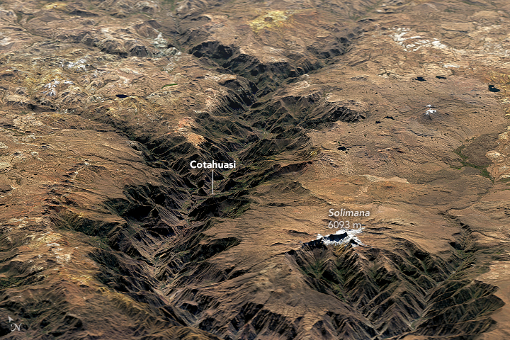
English: Cotahuasi Canyon in Peru stands as a potent reminder of the tremendous erosive power of water and ice. Cutting through a towering plateau—a product of repeated volcanic eruptions and tectonic uplift—the canyon is one of the deepest in the world.
Cotahuasi formed over the course of several million years as rivers and glaciers chiseled into the plateau. The relief from the canyon floor to the rim ranges from 2.5 to 3.5 kilometers (1.5 to 2.2 miles), making Cotahuasi Canyon about twice as deep as the Grand Canyon. On June 3, 2016, the Operational Land Imager (OLI) on Landsat 8 passed over the canyon. The top image shows Landsat data draped over topographic data from NASA’s Shuttle Radar Topography Mission (SRTM). The second image is a nadir (straight down) view from OLI of the area near the town of Cotahuasi. Evidence of volcanic activity surrounds the canyon. To the south, snow-capped Solimana, an inactive stratovolcano that last erupted about 500,000 years ago, soars above the plateau. Colorful yellow and orange volcanic deposits are visible around the north rim of the canyon. More info & refs at source URL |
|||||
| Data | ||||||
| Źródło | https://earthobservatory.nasa.gov/IOTD/view.php?id=91686&src=eoa-iotd | |||||
| Autor | NASA Earth Observatory images by Joshua Stevens, using Landsat data from the U.S. Geological Survey. | |||||
| Licencja (Ponowne użycie tego pliku) |
|

Historia pliku
Kliknij na datę/czas, aby zobaczyć, jak plik wyglądał w tym czasie.
| Data i czas | Miniatura | Wymiary | Użytkownik | Opis | |
|---|---|---|---|---|---|
| aktualny | 00:59, 14 lut 2018 | | 720 × 480 (515 KB) | Tillman | {{Information |Description ={{en|1=Cotahuasi Canyon in Peru stands as a potent reminder of the tremendous erosive power of water and ice. Cutting through a towering plateau—a product of repeated volcanic eruptions and tectonic uplift—the canyon... |
Lokalne wykorzystanie pliku
Poniższa strona korzysta z tego pliku:
Globalne wykorzystanie pliku
Ten plik jest wykorzystywany także w innych projektach wiki:
- Wykorzystanie na en.wikipedia.org
- Wykorzystanie na en.wikivoyage.org
- Wykorzystanie na es.wikipedia.org
- Wykorzystanie na fr.wikivoyage.org
- Wykorzystanie na he.wikivoyage.org
- Wykorzystanie na it.wikivoyage.org
- Wykorzystanie na qu.wikipedia.org
- Wykorzystanie na ru.wikipedia.org
- Wykorzystanie na sv.wikipedia.org
- Wykorzystanie na uk.wikipedia.org
- Wykorzystanie na www.wikidata.org