Plik:Durham UK location map.svg

Wielkość pliku podglądu PNG dla pliku SVG: 800 × 524 pikseli Inne rozdzielczości: 320 × 210 pikseli | 640 × 419 pikseli | 1024 × 671 pikseli | 1280 × 839 pikseli | 2560 × 1678 pikseli | 1425 × 934 pikseli.
Rozmiar pierwotny (Plik SVG, nominalnie 1425 × 934 pikseli, rozmiar pliku: 1,39 MB)
| Plik Durham UK location map.svg znajduje się w Wikimedia Commons – repozytorium wolnych zasobów. Dane z jego strony opisu znajdują się poniżej. |
| Opis |
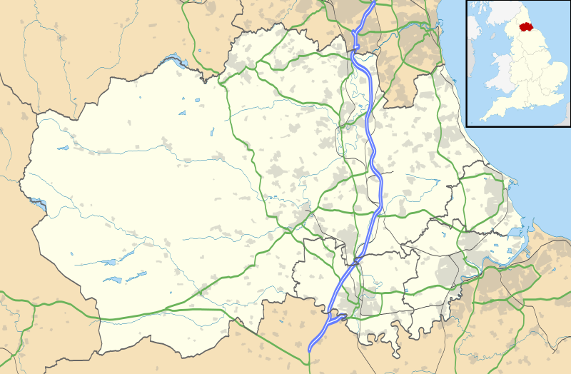
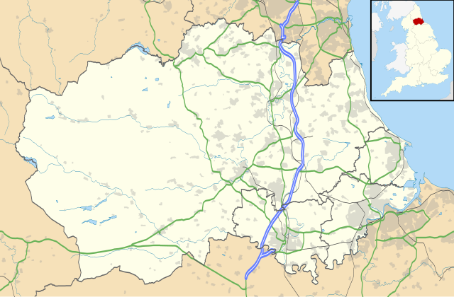
Map of County Durham, UK with the following information shown:
Equirectangular map projection on WGS 84 datum, with N/S stretched 170% Geographic limits:
|
| Data | |
| Źródło |
|
| Autor | Nilfanion, created using Ordnance Survey data |
| Licencja (Ponowne użycie tego pliku) |
Ten plik udostępniony jest na licencji Creative Commons Uznanie autorstwa – Na tych samych warunkach 3.0. Uznanie autorstwa: Contains Ordnance Survey data © Crown copyright and database right
|
| Inne wersje | File:Durham UK district map (blank).svg - Blank map |
.svg)
Historia pliku
Kliknij na datę/czas, aby zobaczyć, jak plik wyglądał w tym czasie.
| Data i czas | Miniatura | Wymiary | Użytkownik | Opis | |
|---|---|---|---|---|---|
| aktualny | 21:04, 26 wrz 2010 | | 1425 × 934 (1,39 MB) | Nilfanion | fixing dodgy layer |
| 20:43, 26 wrz 2010 |  | 1425 × 934 (1,39 MB) | Nilfanion | {{Information |Description=Map of County Durham, UK with the following information shown: *Administrative borders *Coastline, lakes and rivers *Roads and railways *Urban areas Equirectangular map projection on WGS 84 datum, with N/S s |
Lokalne wykorzystanie pliku
Z tego pliku korzysta więcej niż 100 stron. Poniższa lista pokazuje jedynie 100 pierwszych z nich. Dostępna jest również pełna lista.
- Aislaby (Durham)
- Annfield Plain
- Archdeacon Newton
- Aukside
- Aycliffe Village
- Barforth
- Barmpton
- Barnard Castle
- Barningham (Durham)
- Beamish (Durham)
- Bearpark
- Beaumont Hill
- Bedburn
- Belmont (Durham)
- Benfieldside
- Bildershaw
- Billingham
- Billy Row
- Binchester
- Bishop Auckland
- Bishop Middleham
- Bishopsgarth
- Bishopton (Durham)
- Blackhall Colliery
- Blackhall Rocks
- Blackwell (Durham)
- Bolam (Durham)
- Boldron
- Bournmoor
- Bowbank
- Bowburn
- Bowes
- Bowlees
- Bradbury (Durham)
- Brafferton (Durham)
- Brancepeth
- Brandon (Durham)
- Brandon and Byshottles
- Bridge End (Durham)
- Bridgehill
- Brignall
- Broom Hill
- Broompark
- Brotherlee
- Browney
- Burnhope
- Burnopfield
- Butsfield
- Butterknowle
- Butterwick (Durham)
- Byermoor
- Byers Green
- Carlbury
- Carlton (Durham)
- Carrville
- Cassop
- Cassop-cum-Quarrington
- Castle Eden
- Castleside
- Catchgate
- Causey (Durham)
- Chester-le-Street
- Chester Moor
- Chilton (Durham)
- Chilton Lane
- Cleatlam
- Close House
- Clough Dene
- Coatham Mundeville
- Cockerton
- Cockfield (Durham)
- Cold Hesledon
- Consett
- Copley (Durham)
- Copthill
- Cornforth
- Cornriggs
- Crook (Durham)
- Darlington
- Darlington (stacja kolejowa)
- Durham
- Durham (hrabstwo w Anglii)
- Eaglescliffe
- Easington (Durham)
- Easington Colliery
- Ferryhill
- Hartlepool
- Hartlepool (stacja kolejowa)
- Newton Aycliffe
- Peterlee
- Port lotniczy Durham-Tees Valley
- Seaham
- Sedgefield
- Shildon
- Spennymoor
- Stanley (Durham)
- Stockton-on-Tees
- The Darlington Arena
- Tow Law
- Victoria Park (Hartlepool)
Pokaż więcej odnośników do tego pliku.
Globalne wykorzystanie pliku
Ten plik jest wykorzystywany także w innych projektach wiki:
- Wykorzystanie na ar.wikipedia.org
- Wykorzystanie na azb.wikipedia.org
- Wykorzystanie na bg.wikipedia.org
- Wykorzystanie na ceb.wikipedia.org
- Wykorzystanie na en.wikipedia.org
- Tanfield, County Durham
- Durham, England
- Barnard Castle
- Darlington
- Willington, County Durham
- Pity Me
- Chester-le-Street
- Hartlepool
- Stockton-on-Tees
- Bishop Auckland
- Seaham
- Sedgefield
- Peterlee
- Annfield Plain
- Easington, County Durham
- Consett
- Newton Aycliffe
- Catchgate
- Norton, County Durham
- Spennymoor
- Beamish Museum
- Stanley, County Durham
- West Hartlepool
- Ferryhill
- Gainford, County Durham
- Billingham
- Eaglescliffe
- Ushaw College
- Lambton Castle
- No Place
- Burnhope
- Craghead
- Shotley Bridge
- Preston Hall, Preston-on-Tees
- Sacriston
- Cassop
- Teesside International Airport
- White-le-Head
- Tanfield Lea
- Quaking Houses
- South Moor
- Oxhill, County Durham
- Preston-on-Tees
- List of places in County Durham
- Lumley Castle
Pokaż listę globalnego wykorzystania tego pliku.