Plik:Elk Mountains, Colorado (9181504734).jpg

Rozmiar pierwotny (4000 × 3000 pikseli, rozmiar pliku: 2,19 MB, typ MIME: image/jpeg)
| Plik Elk Mountains, Colorado (9181504734).jpg znajduje się w Wikimedia Commons – repozytorium wolnych zasobów. Dane z jego strony opisu znajdują się poniżej. |
.jpg)
Opis
| Opis |
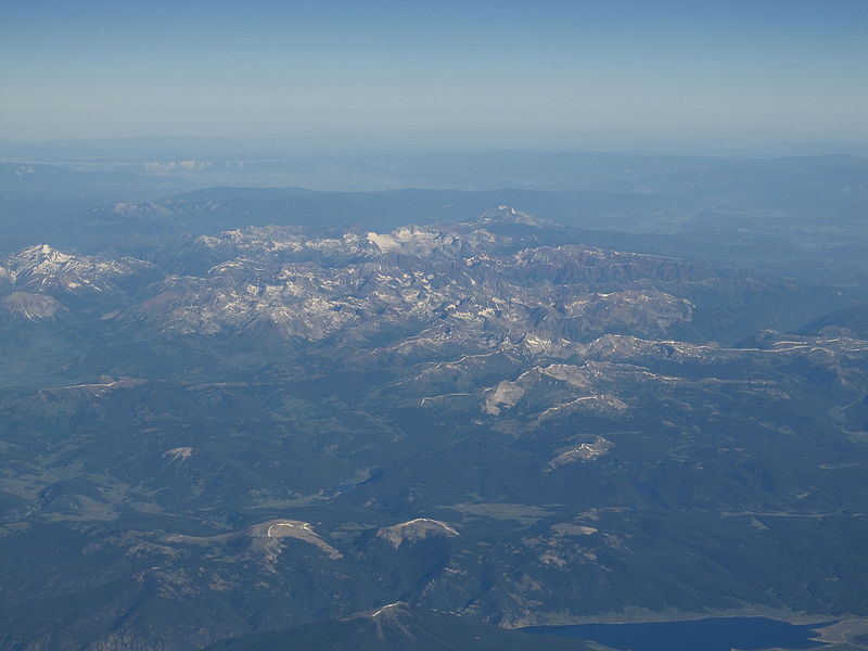
The Elk Mountains are a high, rugged mountain range in the Rocky Mountains of west-central Colorado in the United States. The mountains sit on the western side of the Continental Divide, largely in southern Pitkin and northern Gunnison counties, in the area southwest of Aspen, south of the Roaring Fork River valley, and east of the Crystal River. The range sits west of the Sawatch Range and northeast of the West Elk Mountains. Much of the range is located within the White River National Forest and the Gunnison National Forest, as well as the Maroon Bells-Snowmass Wilderness and Raggeds Wilderness. The Elk Mountains rise nearly 9,000 ft. above the Roaring Fork Valley to the north. The highest peaks in the range are its fourteeners, Castle Peak (14,265 ft), Maroon Peak (14,156 ft), Capitol Peak (14,130 ft), Snowmass Mountain (14,092 ft), Pyramid Peak (14,018 ft), and North Maroon Peak (14,014 ft).[1] Maroon Peak and North Maroon Peak are collectively known as the Maroon Bells, a popular destination for recreation alpinism. Mount Sopris (12,953 ft) sits at the northwest end of the range and dominates the skyline of the lower Roaring Fork Valley and the town of Carbondale, Colorado, serving as an unofficial symbol of the area. en.wikipedia.org/wiki/Elk_Mountains_(Colorado) en.wikipedia.org/wiki/Wikipedia:Text_of_Creative_Commons_... |
| Data | |
| Źródło | Elk Mountains, Colorado |
| Autor | Ken Lund from Reno, Nevada, USA |
| Pozycja fotografa | | To i inne zdjęcia na: OpenStreetMap |
|---|
.jpg¶ms=039.146861_N_-107.085735_E_globe:Earth_type:camera_source:Flickr_&language=pl)
Licencja
- Wolno:
- dzielić się – kopiować, rozpowszechniać, odtwarzać i wykonywać utwór
- modyfikować – tworzyć utwory zależne
- Na następujących warunkach:
- uznanie autorstwa – musisz określić autorstwo utworu, podać link do licencji, a także wskazać czy utwór został zmieniony. Możesz to zrobić w każdy rozsądny sposób, o ile nie będzie to sugerować, że licencjodawca popiera Ciebie lub Twoje użycie utworu.
- na tych samych warunkach – Jeśli zmienia się lub przekształca niniejszy utwór, lub tworzy inny na jego podstawie, można rozpowszechniać powstały w ten sposób nowy utwór tylko na podstawie tej samej lub podobnej licencji.
| Ten plik, opublikowany pierwotnie w serwisie Flickr przez Ken Lund pod adresem https://flickr.com/photos/75683070@N00/9181504734, został sprawdzony 3 grudnia 2015 przez FlickreviewR, który potwierdził, że jest on tam dostępny na licencji cc-by-sa-2.0. |
Historia pliku
Kliknij na datę/czas, aby zobaczyć, jak plik wyglądał w tym czasie.
| Data i czas | Miniatura | Wymiary | Użytkownik | Opis | |
|---|---|---|---|---|---|
| aktualny | 00:54, 4 gru 2015 | | 4000 × 3000 (2,19 MB) | INeverCry | Transferred from Flickr via Flickr2Commons |
Lokalne wykorzystanie pliku
Poniższa strona korzysta z tego pliku:
Globalne wykorzystanie pliku
Ten plik jest wykorzystywany także w innych projektach wiki:
- Wykorzystanie na es.wikipedia.org
.jpg)