Plik:Federation of Rhodesia and Nyasaland map 1960.jpg

Rozmiar podglądu – 556 × 599 pikseli. Inne rozdzielczości: 223 × 240 pikseli | 445 × 480 pikseli | 712 × 768 pikseli | 950 × 1024 pikseli | 1900 × 2048 pikseli | 3436 × 3704 pikseli.
Rozmiar pierwotny (3436 × 3704 pikseli, rozmiar pliku: 9,76 MB, typ MIME: image/jpeg)
| Plik Federation of Rhodesia and Nyasaland map 1960.jpg znajduje się w Wikimedia Commons – repozytorium wolnych zasobów. Dane z jego strony opisu znajdują się poniżej. |
Opis
| Opis |
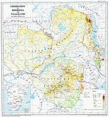
English: A map of the Federation of Rhodesia and Nyasaland, issued by the Government in 1960 |
| Data | |
| Źródło | Originally scanned from Government-issue Federal Atlas issued in 1960. Scan taken from Great North Road website. |
| Autor | Federal Government Printer, Salisbury, Rhodesia and Nyasaland. Copyright owned by the Government of Federation of Rhodesia and Nyasaland |
| Inne wersje |
Licencja
This work was first published in Zimbabwe (or one of its antecedents) and is now in the public domain in Zimbabwe because its copyright protection has expired by virtue of the Copyright and Neighboring Rights Act, enacted 2000 (details). The work meets one of the following criteria:
A Zimbabwean work that is in the public domain in Zimbabwe according to this rule is in the public domain in the U.S. only if it was in the public domain in Zimbabwe in 1996, e.g. if it was published before 1946 and no copyright was registered in the U.S. (This is the effect of the Uruguay Round Agreements Act (17 USC 104A) with its critical date of January 1, 1996.) |
 |
Historia pliku
Kliknij na datę/czas, aby zobaczyć, jak plik wyglądał w tym czasie.
| Data i czas | Miniatura | Wymiary | Użytkownik | Opis | |
|---|---|---|---|---|---|
| aktualny | 23:43, 28 lis 2011 | | 3436 × 3704 (9,76 MB) | P. S. Burton | removed watermark, and slight crop of frame |
| 03:50, 20 paź 2011 |  | 3436 × 3757 (2,76 MB) | Renamed user df576567etesddf | restored watermark per request on website; also file is smaller | |
| 03:14, 20 paź 2011 |  | 3436 × 3695 (9,23 MB) | Renamed user df576567etesddf | {{Information |Description ={{en|1=A map of the Federation of Rhodesia and Nyasaland, issued by the Government in 1960}} |Source =Originally scanned from Government-issue Federal Atlas issued in 1960. Scan taken from [http://www.greatnorthroad. |
Lokalne wykorzystanie pliku
Następujące strony korzystają z tego pliku:
Globalne wykorzystanie pliku
Ten plik jest wykorzystywany także w innych projektach wiki:
- Wykorzystanie na als.wikipedia.org
- Wykorzystanie na de.wikipedia.org
- Wykorzystanie na en.wikipedia.org
- Wykorzystanie na en.wikibooks.org
- Wykorzystanie na es.wikipedia.org
- Wykorzystanie na mt.wikipedia.org
- Wykorzystanie na tum.wikipedia.org