Plik:Great Basin National Park map 2007.04.png

Rozmiar podglądu – 679 × 600 pikseli. Inne rozdzielczości: 272 × 240 pikseli | 543 × 480 pikseli | 869 × 768 pikseli | 1159 × 1024 pikseli | 1647 × 1455 pikseli.
Rozmiar pierwotny (1647 × 1455 pikseli, rozmiar pliku: 649 KB, typ MIME: image/png)
| Plik Great Basin National Park map 2007.04.png znajduje się w Wikimedia Commons – repozytorium wolnych zasobów. Dane z jego strony opisu znajdują się poniżej. |
Opis
| Opis |
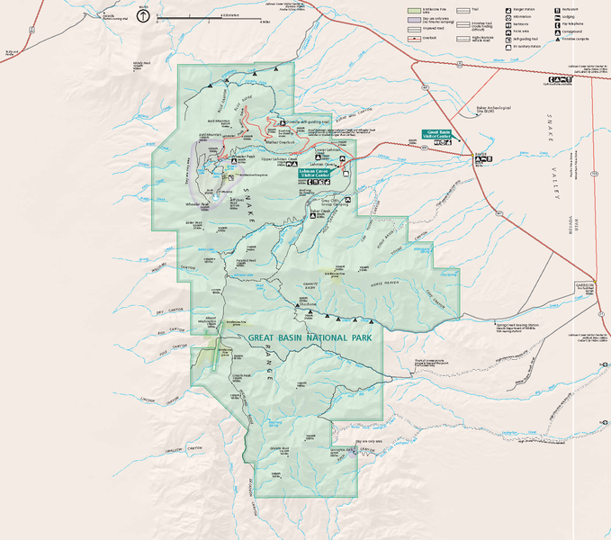
Official National Park Service map — of Great Basin National Park.
GRBAmap1.pdf |
| Data | |
| Źródło | [1] |
| Autor | National Park Service, Harpers Ferry Center |
| Licencja (Ponowne użycie tego pliku) |
"The maps at this site are in the public domain. You may use National Park Service maps provided that you agree to assume complete legal responsibility for problems resulting from their use. Although National Park Service maps are easy to modify, understand that modifications can adversely alter the meaning and accuracy of the original data. Law prohibits you from using the National Park Service seal or claiming National Park Service endorsement with downloaded maps." [2] |
Licencja
| This image or media file contains material based on a work of a National Park Service employee, created as part of that person's official duties. As a work of the U.S. federal government, such work is in the public domain in the United States. See the NPS website and NPS copyright policy for more information. |
Historia pliku
Kliknij na datę/czas, aby zobaczyć, jak plik wyglądał w tym czasie.
| Data i czas | Miniatura | Wymiary | Użytkownik | Opis | |
|---|---|---|---|---|---|
| aktualny | 06:48, 14 paź 2007 | | 1647 × 1455 (649 KB) | Werewombat | == Summary == {{Information |Description = Official National Park Service map of en:Great Basin National Park, en:Nevada. Converted from PDF using Adobe Acrobat 7.0 Professional. O |
Lokalne wykorzystanie pliku
Poniższa strona korzysta z tego pliku:
Globalne wykorzystanie pliku
Ten plik jest wykorzystywany także w innych projektach wiki:
- Wykorzystanie na cs.wikipedia.org
- Wykorzystanie na da.wikipedia.org
- Wykorzystanie na fr.wikipedia.org
- Wykorzystanie na he.wikipedia.org
- Wykorzystanie na hu.wikipedia.org
- Wykorzystanie na is.wikipedia.org
- Wykorzystanie na nl.wikipedia.org
- Wykorzystanie na ru.wikipedia.org
- Wykorzystanie na tr.wikipedia.org