Plik:Le Castellet circuit map Formula One 2018 without corner names English 29 06 2021.svg

Wielkość pliku podglądu PNG dla pliku SVG: 673 × 599 pikseli Inne rozdzielczości: 270 × 240 pikseli | 539 × 480 pikseli | 863 × 768 pikseli | 1150 × 1024 pikseli | 2300 × 2048 pikseli | 2191 × 1951 pikseli.
Rozmiar pierwotny (Plik SVG, nominalnie 2191 × 1951 pikseli, rozmiar pliku: 59 KB)
| Plik Le Castellet circuit map Formula One 2018 without corner names English 29 06 2021.svg znajduje się w Wikimedia Commons – repozytorium wolnych zasobów. Dane z jego strony opisu znajdują się poniżej. |
Opis
| Opis |
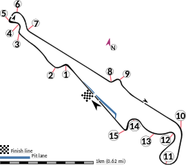
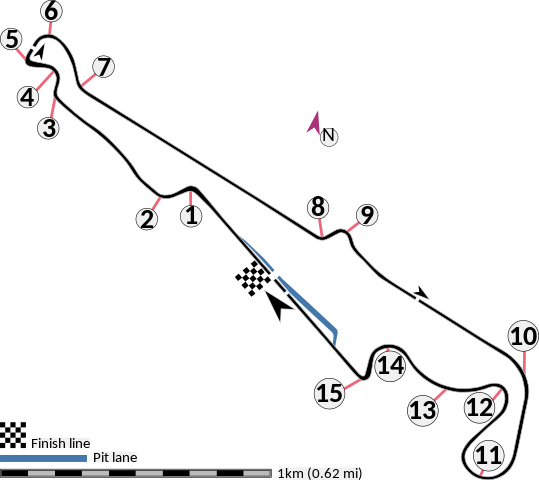
English: This is an altered version of File:Le Castellet circuit map Formula One 2018 without corner names June 2021.svg with the key solely in English and a few other alterations. This is a map of the Le Castellet motor circuit as it was used by w:en:Formula One for the w:en:2018 French Grand Prix, before the pit lane entrances and exits were reconfigured, and includes corner numbers and other information sourced from the FIA's map of the circuit. This map is valid for races which use this layout and corner numbering scheme, please upload a new file for races which use different layouts or corner numbering schemes rather than replacing this file. As this is a free-hand map drawn by an enthusiast rather than a professional cartographer's work it may contain some errors, although checking it against other maps it appears accurate enough for most purposes. The track is shown in black with a grey outline, while the pit lane is shown in blue. A scale showing the length of one kilometre (with increments of 100 metres) is given, to allow viewers to contextualise and understand what they are looking at. Corner numbers and other important text is given an off-white background to avoid transparency issues rendering it illegible on certain devices. A thick white line covering the track and the pit lane, marked with a chequered flag, shows the location of the start/finish line, also known as the control or timing line. A thinner white line, covering only the track, shows the location of pole position, and is marked with a large black arrow indicating the direction of travel. There are also thin white lines crossing the track which indicate the ends of the first and second timing sectors used by Formula One; these are marked with smaller black arrows, which also indicate the direction of travel. The mauve arrow marked "N" shows the direction of north.
Arrow pointing north Pit lane Links corner number to location of corner |
| Data | |
| Źródło | Praca własna |
| Autor | HumanBodyPiloter5 |
| Inne wersje |
   |
Licencja
Ja, właściciel praw autorskich do tego dzieła, udostępniam je na poniższej licencji
| Ten plik udostępniony jest na licencji Creative Commons CC0 1.0 Uniwersalna Licencja Domeny Publicznej. | |
| Osoby, które współpracowały przy tworzeniu tego utworu przeniosły go do domeny publicznej poprzez zrezygnowanie ze wszystkich przysługujących im praw na obszarze całego świata z tytułu prawa autorskiego oraz wszystkich powiązanych i podobnych praw, w zakresie dopuszczalnym przez prawo. Możesz kopiować, zmieniać, rozprowadzać i wykonywać to dzieło, nawet wykorzystując do celów komercyjnych bez pytania o pozwolenie.
|
Historia pliku
Kliknij na datę/czas, aby zobaczyć, jak plik wyglądał w tym czasie.
| Data i czas | Miniatura | Wymiary | Użytkownik | Opis | |
|---|---|---|---|---|---|
| aktualny | 03:15, 29 cze 2021 | | 2191 × 1951 (59 KB) | HumanBodyPiloter5 | Uploaded own work with UploadWizard |
Lokalne wykorzystanie pliku
Następujące strony korzystają z tego pliku:
Globalne wykorzystanie pliku
Ten plik jest wykorzystywany także w innych projektach wiki:
- Wykorzystanie na af.wikipedia.org
- Wykorzystanie na en.wikipedia.org
- Wykorzystanie na fi.wikipedia.org
- Wykorzystanie na fr.wikipedia.org
- Wykorzystanie na fy.wikipedia.org
- Wykorzystanie na gl.wikipedia.org
- Wykorzystanie na hr.wikipedia.org
- Wykorzystanie na hu.wikipedia.org
- Wykorzystanie na id.wikipedia.org
- Wykorzystanie na it.wikipedia.org
- Wykorzystanie na ro.wikipedia.org
- Wykorzystanie na tr.wikipedia.org