Plik:London Underground Overground DLR Crossrail map.svg

Wielkość pliku podglądu PNG dla pliku SVG: 800 × 422 pikseli Inne rozdzielczości: 320 × 169 pikseli | 640 × 338 pikseli | 1024 × 541 pikseli | 1280 × 676 pikseli | 2560 × 1352 pikseli | 2500 × 1320 pikseli.
Rozmiar pierwotny (Animowany plik SVG, nominalnie 2500 × 1320 pikseli, rozmiar pliku: 219 KB)
Uwaga: z powodu ograniczeń technicznych miniaturki tego pliku nie bedą animowane.
| Plik London Underground Overground DLR Crossrail map.svg znajduje się w Wikimedia Commons – repozytorium wolnych zasobów. Dane z jego strony opisu znajdują się poniżej. |
Opis
| Opis |
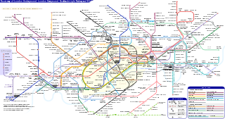
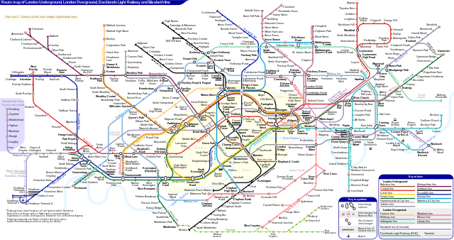
English: *Route map of London Underground, London Overground, Docklands Light Railway and Elizabeth line (Crossrail), including most green-lighted proposals.
|
|||
| Data | ||||
| Źródło | Praca własna | |||
| Autor | Sameboat | |||
| Licencja (Ponowne użycie tego pliku) |
Ja, właściciel praw autorskich do tego dzieła, udostępniam je na poniższej licencji Ten plik udostępniony jest na licencji Creative Commons Uznanie autorstwa – Na tych samych warunkach 4.0 Międzynarodowe.
|
|||
| Inne wersje |
|
|||
| SVG rozwój | Kod źródłowy tego poprawny. Ta ikona została stworzona za pomocą Other tools This icon uses embedded text that can be easily translated using a text editor. |


|
This image is an animated SVG file. The .png preview above created by RSVG for use in Wikimedia is not animated and may be incomplete or incorrect. To see the animation, open media:London Underground Overground DLR Crossrail map.svg. It should run in any modern browser or viewer. Recent versions of Chrome, Firefox, Microsoft Edge, Safari, and Opera all support SVG animated with SMIL.
Other SVG animations can be found at Category:Animated SVG files.
|

Historia pliku
Kliknij na datę/czas, aby zobaczyć, jak plik wyglądał w tym czasie.
| Data i czas | Miniatura | Wymiary | Użytkownik | Opis | |
|---|---|---|---|---|---|
| aktualny | 08:27, 25 mar 2024 | | 2500 × 1320 (219 KB) | Sameboat | change OOC icon to NR |
| 08:22, 23 mar 2024 |  | 2500 × 1320 (219 KB) | Sameboat | restore changes made by The wub and Jc86035 | |
| 08:17, 23 mar 2024 |  | 2500 × 1320 (219 KB) | Sameboat | + Old Oak Common | |
| 01:16, 20 mar 2024 |  | 2500 × 1320 (219 KB) | The wub | Update cable car, add tooltip for Woolwich/Woolwich Arsenal interchange | |
| 23:54, 19 lut 2024 |  | 2500 × 1320 (219 KB) | Jc86035 | Wandsworth Road | |
| 03:09, 19 lut 2024 |  | 2500 × 1320 (219 KB) | Sameboat | ||
| 16:42, 16 lut 2024 |  | 2500 × 1320 (219 KB) | Sameboat | ||
| 16:37, 16 lut 2024 |  | 2500 × 1320 (219 KB) | Sameboat | overground new names and new colors | |
| 08:03, 7 lis 2022 |  | 2500 × 1320 (221 KB) | Sameboat | Pudding Mill Lane portal | |
| 07:19, 6 lis 2022 |  | 2500 × 1320 (224 KB) | Sameboat | Elizabeth line thru Paddington |
Lokalne wykorzystanie pliku
Następujące strony korzystają z tego pliku:
Globalne wykorzystanie pliku
Ten plik jest wykorzystywany także w innych projektach wiki:
- Wykorzystanie na af.wikipedia.org
- Wykorzystanie na ar.wikipedia.org
- Wykorzystanie na ca.wikipedia.org
- Wykorzystanie na de.wikipedia.org
- Wykorzystanie na en.wikipedia.org
- Tube map
- Transport for London
- Schematic
- List of London Underground stations
- London Rail
- Wikipedia:Wikipedia Signpost/2015-06-03/In the media
- Wikipedia:Wikipedia Signpost/Single/2015-06-03
- User:Bellowhead678/sandbox
- Elizabeth line
- User:RogerNiceEyes/sandbox
- Talk:Elizabeth line
- Glossary of geography terms (N–Z)
- Wykorzystanie na en.wikivoyage.org
- Wykorzystanie na es.wikipedia.org
- Wykorzystanie na es.wikivoyage.org
- Wykorzystanie na fa.wikipedia.org
- Wykorzystanie na fi.wikipedia.org
- Wykorzystanie na fr.wikipedia.org
- Liste des stations du métro de Londres
- Woodside Park (métro de Londres)
- Gare de Moorgate
- High Barnet (métro de Londres)
- Totteridge & Whetstone (métro de Londres)
- Morden (métro de Londres)
- Burnt Oak (métro de Londres)
- West Finchley (métro de Londres)
- Brent Cross (métro de Londres)
- Golders Green (métro de Londres)
- Kensal Green (métro de Londres)
- Queen's Park (métro de Londres)
- Finchley Central (métro de Londres)
- Colliers Wood (métro de Londres)
- Mill Hill East (métro de Londres)
- Edgware (métro de Londres)
- Balham (métro de Londres)
- Barking (métro de Londres)
- Colindale (métro de Londres)
- Hendon Central (métro de Londres)
- Kilburn Park (métro de Londres)
Pokaż listę globalnego wykorzystania tego pliku.