Plik:Map of New York highlighting Richmond County.svg

Wielkość pliku podglądu PNG dla pliku SVG: 787 × 600 pikseli Inne rozdzielczości: 315 × 240 pikseli | 630 × 480 pikseli | 1008 × 768 pikseli | 1280 × 975 pikseli | 2560 × 1950 pikseli | 1100 × 838 pikseli.
Rozmiar pierwotny (Plik SVG, nominalnie 1100 × 838 pikseli, rozmiar pliku: 66 KB)
| Plik Map of New York highlighting Richmond County.svg znajduje się w Wikimedia Commons – repozytorium wolnych zasobów. Dane z jego strony opisu znajdują się poniżej. |
Opis
| Opis |
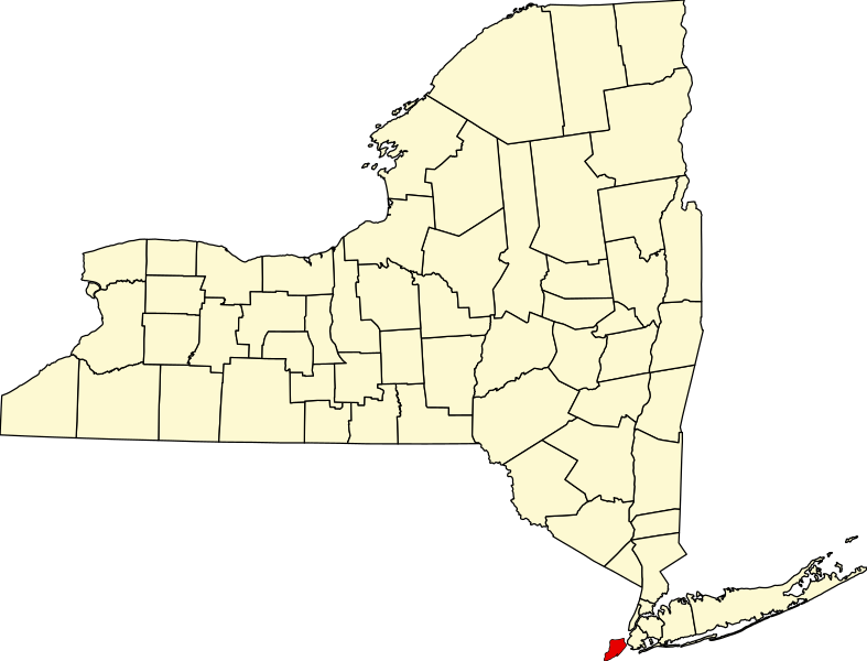
English: This is a locator map showing Richmond County in New York. For more information, see Commons:United States county locator maps. |
| Data | |
| Źródło |
Praca własna: English: The maps use data from nationalatlas.gov, specifically countyp020.tar.gz on the Raw Data Download page. The maps also use state outline data from statesp020.tar.gz. The Florida maps use hydrogm020.tar.gz to display Lake Okeechobee. |
| Autor | David Benbennick |
Licencja
| Ja, właściciel praw autorskich do tej pracy, udostępniam ją jako własność publiczną. Dotyczy to całego świata. W niektórych krajach może nie być to prawnie możliwe, jeśli tak, to: Zapewniam każdemu prawo do użycia tej pracy w dowolnym celu, bez żadnych ograniczeń, chyba że te ograniczenia są wymagane przez prawo. |
Historia pliku
Kliknij na datę/czas, aby zobaczyć, jak plik wyglądał w tym czasie.
| Data i czas | Miniatura | Wymiary | Użytkownik | Opis | |
|---|---|---|---|---|---|
| aktualny | 17:26, 25 cze 2024 | | 1100 × 838 (66 KB) | Nux | uniform colors with good contrast |
| 23:13, 15 cze 2024 |  | 1650 × 1257 (66 KB) | Nux | fix (remove clip-path) | |
| 17:33, 12 lut 2006 |  | 6599 × 5030 (112 KB) | David Benbennick | {{subst:User:Dbenbenn/clm|county=Richmond County|state=New York|type=county}} |
Lokalne wykorzystanie pliku
Poniższa strona korzysta z tego pliku:
Globalne wykorzystanie pliku
Ten plik jest wykorzystywany także w innych projektach wiki:
- Wykorzystanie na azb.wikipedia.org
- Wykorzystanie na bpy.wikipedia.org
- Wykorzystanie na cy.wikipedia.org
- Wykorzystanie na de.wikipedia.org
- Wykorzystanie na en.wikipedia.org
- List of counties in New York
- Richmondtown, Staten Island
- Isle of Meadows
- Prall's Island
- Stapleton Heights, Staten Island
- Castleton, Staten Island
- Arrochar, Staten Island
- Richmond Creek (Fresh Kills)
- Wikipedia:WikiProject New York City
- Annadale, Staten Island
- Richmond Valley, Staten Island
- Bay Terrace, Staten Island
- Sunnyside, Staten Island
- Concord, Staten Island
- Meiers Corners, Staten Island
- Ward Hill, Staten Island
- Emerson Hill, Staten Island
- Egbertville, Staten Island
- Greenridge, Staten Island
- Randall Manor, Staten Island
- Shore Acres, Staten Island
- Brighton Heights, Staten Island
- Port Ivory, Staten Island
- National Register of Historic Places listings in Staten Island
- Aspen Knolls
- Manor Heights, Staten Island
- Tappen Park
- Long Pond Park
- Bloomingdale Park
- Wolfe's Pond Park
- New Creek (Staten Island)
- Template:StatenIsland-geo-stub
- Willowbrook Park
- Arlington, Staten Island
- Chelsea, Staten Island
- Old Place, Staten Island
- Southfield, Staten Island
- Middletown, Staten Island
- Westfield, Staten Island
- Northfield, Staten Island
- Fresh Kills
- Tompkins Circle
- Ingram Woods
- User:AridCeption/sandbox
Pokaż listę globalnego wykorzystania tego pliku.