Plik:Montenegro Map.png

Rozmiar pierwotny (2427 × 1807 pikseli, rozmiar pliku: 1,03 MB, typ MIME: image/png)
| Plik Montenegro Map.png znajduje się w Wikimedia Commons – repozytorium wolnych zasobów. Dane z jego strony opisu znajdują się poniżej. |
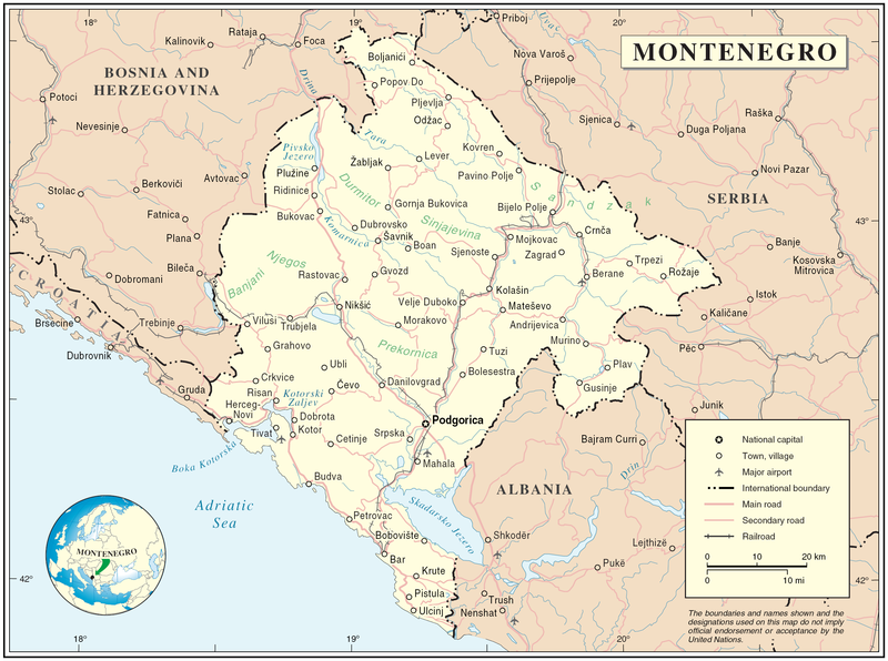
Map of Montenegro
| Opis | Map of Montenegro | |||
| Data | ||||
| Źródło | The Cartographic Section of the United Nations (CSUN) | |||
| Autor | Cartographer of the United Nations | |||
| Licencja (Ponowne użycie tego pliku) |
|

Historia pliku
Kliknij na datę/czas, aby zobaczyć, jak plik wyglądał w tym czasie.
| Data i czas | Miniatura | Wymiary | Użytkownik | Opis | |
|---|---|---|---|---|---|
| aktualny | 19:03, 10 mar 2007 | | 2427 × 1807 (1,03 MB) | Minestrone | Map of Montenegro {{Information |Description=Map of Montenegro |Source=The Cartographic Section of the United Nations (CSUN) |Date=2007-03-10 |Author=Cartographer of the United Nations |Permission={{Template:UN map}} and the cartographer of the UN [ |
Lokalne wykorzystanie pliku
Poniższa strona korzysta z tego pliku:
Globalne wykorzystanie pliku
Ten plik jest wykorzystywany także w innych projektach wiki:
- Wykorzystanie na als.wikipedia.org
- Wykorzystanie na ar.wikipedia.org
- Wykorzystanie na avk.wikipedia.org
- Wykorzystanie na be-tarask.wikipedia.org
- Wykorzystanie na bg.wikipedia.org
- Wykorzystanie na cs.wikipedia.org
- Wykorzystanie na cy.wikipedia.org
- Wykorzystanie na de.wikipedia.org
- Wykorzystanie na el.wikipedia.org
- Wykorzystanie na en.wikipedia.org
- Wykorzystanie na fa.wikipedia.org
- Wykorzystanie na fr.wikipedia.org
- Wykorzystanie na gag.wikipedia.org
- Wykorzystanie na gd.wikipedia.org
- Wykorzystanie na hr.wiktionary.org
- Wykorzystanie na ia.wikipedia.org
- Wykorzystanie na incubator.wikimedia.org
- Wykorzystanie na io.wikipedia.org
- Wykorzystanie na ka.wikipedia.org
- Wykorzystanie na la.wikipedia.org
- Wykorzystanie na ms.wikipedia.org
- Wykorzystanie na nl.wikipedia.org
- Wykorzystanie na pl.wiktionary.org
- Wykorzystanie na pnb.wikipedia.org
- Wykorzystanie na ps.wikipedia.org
- Wykorzystanie na rm.wikipedia.org
- Wykorzystanie na roa-tara.wikipedia.org
- Wykorzystanie na ro.wikipedia.org
- Wykorzystanie na ro.wikivoyage.org
- Wykorzystanie na ru.wikipedia.org
Pokaż listę globalnego wykorzystania tego pliku.