Plik:Roman expansion 264 BC Shepherd.jpg

Rozmiar pierwotny (2302 × 1812 pikseli, rozmiar pliku: 873 KB, typ MIME: image/jpeg)
| Plik Roman expansion 264 BC Shepherd.jpg znajduje się w Wikimedia Commons – repozytorium wolnych zasobów. Dane z jego strony opisu znajdują się poniżej. |
This image was copied from wikipedia:de. The original description was:
| Opis |
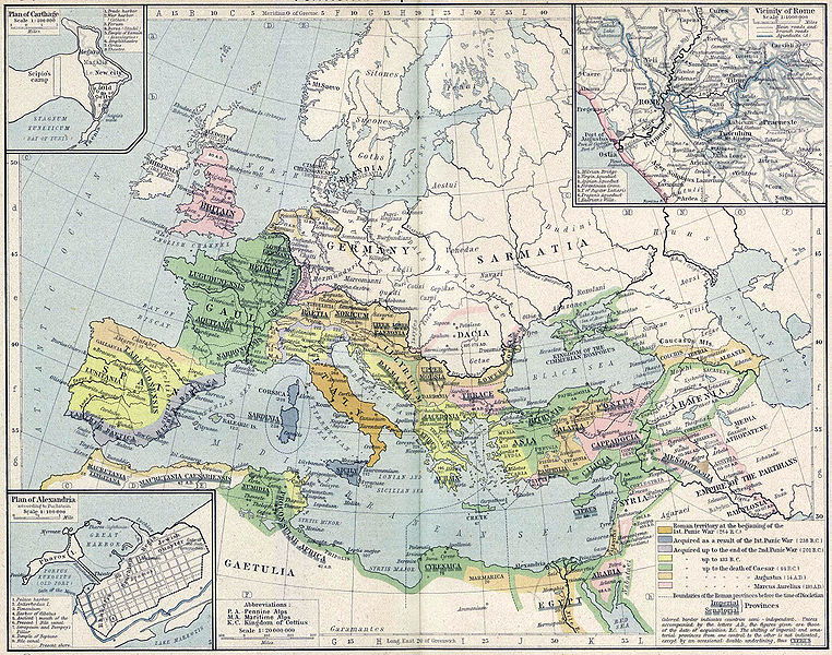
English: Roman territory, from the beginning of the 1st punic war (264 B.C.) to the death of Diocletian
Deutsch: Römisches Reich vom Beginn des 1. Punischen Kriegs (264 v.Chr.) bis zum Tod von Diokletian (312) im Historischen Atlas von William R. Shepherd (1923) |
| Data | 1923 |
| Źródło | "Historical Atlas" by William R. Shepherd, New York, Henry Holt and Company |
| Autor | William R. Shepherd |
| Inne wersje |
|
Ten materiał przeszedł do domeny publicznej w kraju pochodzenia, jak również w państwach i terytoriach, gdzie prawo autorskie wygasa w ciągu 70 lat po śmierci autora.
| |
| Plik rozpoznano jako wolny od znanych ograniczeń praw autorskich, włącznie z prawami zależnymi i pokrewnymi. | |
| date/time | username | edit summary |
|---|---|---|
| 18:08, 21. Feb 2005 | Benowar | ("Historical Atlas" by William R. Shepherd, New York, Henry Holt and Company, 1923 PUBLIC DOMAIN) |
Historia pliku
Kliknij na datę/czas, aby zobaczyć, jak plik wyglądał w tym czasie.
| Data i czas | Miniatura | Wymiary | Użytkownik | Opis | |
|---|---|---|---|---|---|
| aktualny | 19:08, 18 kwi 2006 | | 2302 × 1812 (873 KB) | Crux | verbesserte Version |
| 18:53, 18 kwi 2006 |  | 2302 × 1812 (767 KB) | Crux | This image was copied from wikipedia:de. The original description was: {{Information| |Description=Roman territory at the beginning of the 1st punic war (264 B.C.) |Source="Historical Atlas" by William R. Shepherd, New York, Henry Holt and Company |Date= |
Lokalne wykorzystanie pliku
Żadna strona nie korzysta z tego pliku.
Globalne wykorzystanie pliku
Ten plik jest wykorzystywany także w innych projektach wiki:
- Wykorzystanie na ast.wikipedia.org
- Wykorzystanie na ba.wikipedia.org
- Wykorzystanie na bn.wikipedia.org
- Wykorzystanie na br.wikipedia.org
- Wykorzystanie na ca.wikipedia.org
- Wykorzystanie na de.wikipedia.org
- Wykorzystanie na de.wikibooks.org
- Wykorzystanie na en.wikipedia.org
- Wykorzystanie na es.wikipedia.org
- Wykorzystanie na fr.wikipedia.org
- Wykorzystanie na fy.wikipedia.org
- Wykorzystanie na it.wikipedia.org
- Wykorzystanie na it.wikibooks.org
- Wykorzystanie na lv.wikipedia.org
- Wykorzystanie na mk.wikipedia.org
- Wykorzystanie na mwl.wikipedia.org
- Wykorzystanie na pnb.wikipedia.org
- Wykorzystanie na pt.wikipedia.org
- Wykorzystanie na ru.wikipedia.org
- Wykorzystanie na sa.wikipedia.org
- Wykorzystanie na skr.wikipedia.org
- Wykorzystanie na sk.wikipedia.org
- Wykorzystanie na sl.wikipedia.org
- Wykorzystanie na sq.wikipedia.org
- Wykorzystanie na ur.wikipedia.org
- Wykorzystanie na vi.wikipedia.org
- Wykorzystanie na zh.wikipedia.org