Plik:The start of the A601(M) - geograph.org.uk - 766525.jpg
Grafika w wyższej rozdzielczości nie jest dostępna.
The_start_of_the_A601(M)_-_geograph.org.uk_-_766525.jpg (640 × 426 pikseli, rozmiar pliku: 63 KB, typ MIME: image/jpeg)
| Plik The start of the A601(M) - geograph.org.uk - 766525.jpg znajduje się w Wikimedia Commons – repozytorium wolnych zasobów. Dane z jego strony opisu znajdują się poniżej. |
_-_geograph.org.uk_-_766525.jpg)
Opis
| Opis |
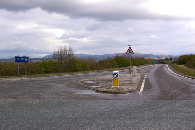
English: The start of the A601(M) The A601(M) has two parts - the part west of Junction 35 with the M6 is a dual carriageway link to the A6, and once formed the northern end of the M6 until the main motorway was extended northwards. But the eastern part was added in 1987 to enable lorries from the quarries to the south to join the M6 without having to go through Carnforth. Its potential usage didn't justify a full blown dual carriageway, but because it gave nowhere to go for non-motorway traffic, it had to be designated a motorway. The result: a stretch of single carriageway motorway, with two way traffic, which ends at a T junction with a B road (the B6254), as shown here! Note the motorway and two way traffic signs.
Not as impressive in length as what was the A6144(M) in Greater Manchester (SJ7793), which is also single carriageway but alas is now no longer a motorway, despite what the map for the square still shows (and unfortunately there are no photos of it on Geograph), but the A601(M) is still a worthy feature of the UK road network. In particular, being a motorway without speed limit indications, it presumably has a 70mph speed limit - one of the few places in the country where one can legally travel at 70mph on a non-dual carriageway, not that the stretch of road is really long enough to allow it! |
| Data | |
| Źródło | From geograph.org.uk |
| Autor | Ian Capper |
| Uznanie autorstwa (wymagana przez licencję) | Ian Capper / The start of the A601(M) / |
| Pozycja fotografa | | To i inne zdjęcia na: OpenStreetMap |
|---|
_-_geograph.org.uk_-_766525.jpg¶ms=054.123730_N_-002.753000_E_globe:Earth_type:camera_source:geograph-osgb36(SD50887002)_heading:45.00&language=pl)
| Pozycja obiektu | | To i inne zdjęcia na: OpenStreetMap |
|---|
_-_geograph.org.uk_-_766525.jpg¶ms=054.124090_N_-002.752500_E_globe:Earth_class:object_type:object_source:geograph-osgb36(SD50917006)_heading:45.00&language=pl)
Licencja

|
Ta grafika pochodzi z kolekcji projektu Geograph. Aby zobaczyć szczegóły możesz odwiedzić stronę tego zdjęcia w serwisie Geograph. Prawa autorskie do tej grafiki posiada Ian Capper i jest ona udostępniona na licencji Creative Commons Uznanie autorstwa – Na tych samych warunkach 2.0.
|
Ten plik udostępniony jest na licencji Creative Commons Uznanie autorstwa – Na tych samych warunkach 2.0.
Uznanie autorstwa: Ian Capper
- Wolno:
- dzielić się – kopiować, rozpowszechniać, odtwarzać i wykonywać utwór
- modyfikować – tworzyć utwory zależne
- Na następujących warunkach:
- uznanie autorstwa – musisz określić autorstwo utworu, podać link do licencji, a także wskazać czy utwór został zmieniony. Możesz to zrobić w każdy rozsądny sposób, o ile nie będzie to sugerować, że licencjodawca popiera Ciebie lub Twoje użycie utworu.
- na tych samych warunkach – Jeśli zmienia się lub przekształca niniejszy utwór, lub tworzy inny na jego podstawie, można rozpowszechniać powstały w ten sposób nowy utwór tylko na podstawie tej samej lub podobnej licencji.
Historia pliku
Kliknij na datę/czas, aby zobaczyć, jak plik wyglądał w tym czasie.
| Data i czas | Miniatura | Wymiary | Użytkownik | Opis | |
|---|---|---|---|---|---|
| aktualny | 21:58, 19 lut 2011 | | 640 × 426 (63 KB) | GeographBot | == {{int:filedesc}} == {{Information |description={{en|1=The start of the A601(M) The A601(M) has two parts - the part west of Junction 35 with the M6 is a dual carriageway link to the A6, and once formed the northern end of the M6 until the main motorway |
Lokalne wykorzystanie pliku
Poniższa strona korzysta z tego pliku:
Globalne wykorzystanie pliku
Ten plik jest wykorzystywany także w innych projektach wiki:
- Wykorzystanie na en.wikipedia.org
- Wykorzystanie na www.wikidata.org
_-_geograph.org.uk_-_766525.jpg)