Plik:The wars of Matthias Corvinus of Hungary (1458-1490).png

Rozmiar podglądu – 597 × 599 pikseli. Inne rozdzielczości: 239 × 240 pikseli | 478 × 480 pikseli | 765 × 768 pikseli | 1020 × 1024 pikseli | 1700 × 1707 pikseli.
Rozmiar pierwotny (1700 × 1707 pikseli, rozmiar pliku: 637 KB, typ MIME: image/png)
| Plik The wars of Matthias Corvinus of Hungary (1458-1490).png znajduje się w Wikimedia Commons – repozytorium wolnych zasobów. Dane z jego strony opisu znajdują się poniżej. |
.png)
Opis
| Opis |
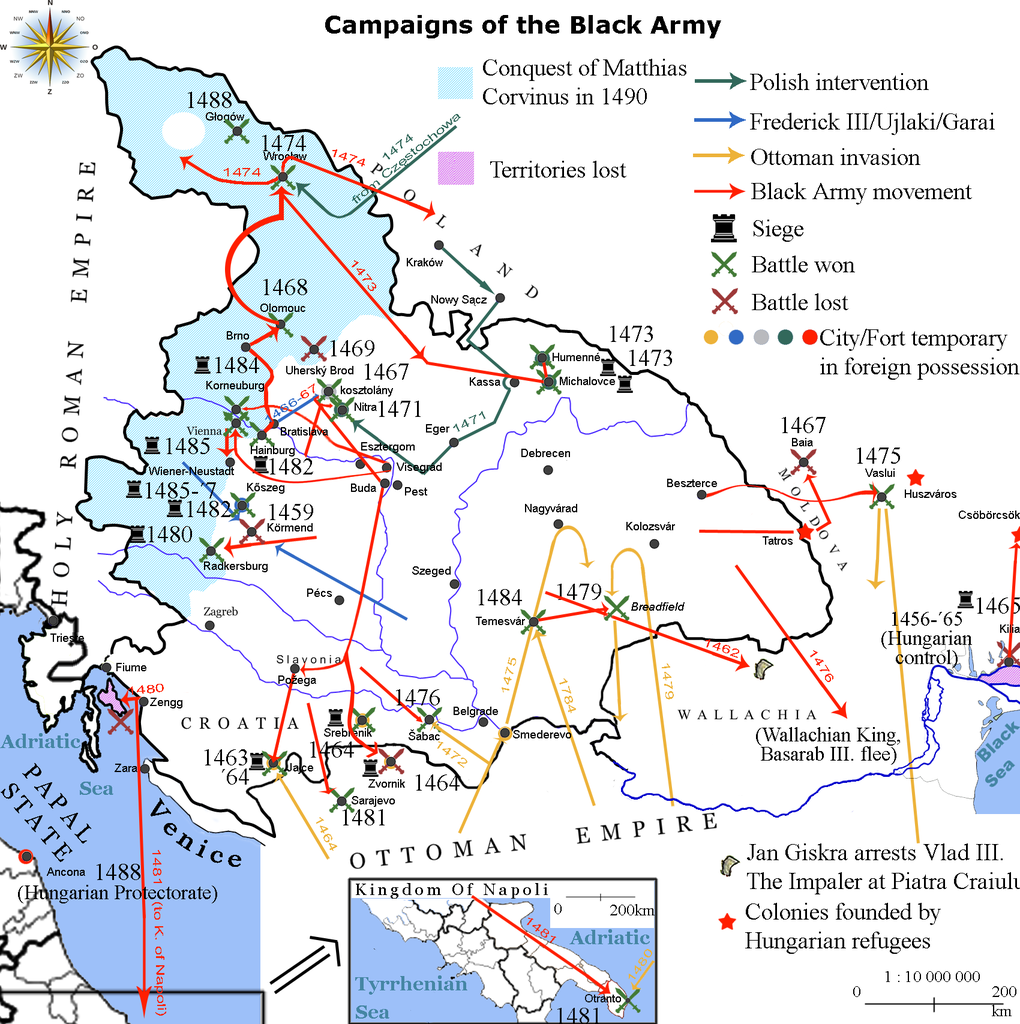
English: Map showing the direction of attacks in/of Hungary and in/of the surrounding countries in the middle of 15th century concentrating on the Black Army of Hungary. |
| Data | |
| Źródło | own work based on the map Map of Hungary in 1490. Historical information is taken from Történelmi világatlasz, Budapest, Hungary, 1991, Kartográfiai Vállalat, ISBN 963-351-696-X-CM and Fenyvesi, László (1990). Mátyás Király fekete serege, Budapest, Hungary: Zrínyi Katonai Kiadó. ISBN 9633260170 Invalid ISBN. |
| Autor | Viztarp (dyskusja · edycje), Alex:D (dyskusja · edycje) |
Licencja
Lajbi z angielskiej Wikipedii – właściciel praw autorskich do tego dzieła, udostępnia je na poniższej licencji
Ten plik udostępniony jest na licencji Creative Commons Uznanie autorstwa 3.0.
Uznanie autorstwa: Lajbi z angielskiej Wikipedii
- Wolno:
- dzielić się – kopiować, rozpowszechniać, odtwarzać i wykonywać utwór
- modyfikować – tworzyć utwory zależne
- Na następujących warunkach:
- uznanie autorstwa – musisz określić autorstwo utworu, podać link do licencji, a także wskazać czy utwór został zmieniony. Możesz to zrobić w każdy rozsądny sposób, o ile nie będzie to sugerować, że licencjodawca popiera Ciebie lub Twoje użycie utworu.
Oryginalny rejestr przesyłania
Oryginalna strona opisu była tutaj. Wszystkie poniższe nazwy użytkowników odwołują się do en.wikipedia.
| Data/czas | Wymiary | Użytkownik | Opis |
|---|---|---|---|
| 2010-10-20 11:26 | 1700×1707× (652065 bytes) | Lajbi | distinguished Nitra from Kosztolány - corrected Moldvian campaign route |
| 2010-10-19 11:31 | 1700×1707× (649221 bytes) | Lajbi | colored the mini map - fixed the dates - added the HUungarian colonies - added Vlad Tepes' arrest |
| 2010-10-12 21:45 | 1700×1707× (631386 bytes) | Lajbi | Added coast of the Black Sea with the Danube Delta - Colored water - Added "Lost territories" |
| 2010-10-11 16:05 | 1500×1707× (577525 bytes) | Lajbi | *Fixed southern border *Added Battle of Timisosara in 1484 *Added port of Zengg as a starting place for maritine campaigns *Added first Polish intervention *Added northern powlings of Hungarian light cavalry *Added more temporary changes in cities ownersh |
| 2010-10-08 12:50 | 1500×1707× (542278 bytes) | Lajbi | {{Information |Description=Map showing the direction of attacks in/of Hungary and in/of the surrounding countries in the middle of 15th century concentrating on the Black Army of Hungary. |Source=own work based on the map [[File:Map of Hungary in 1490.png |
Historia pliku
Kliknij na datę/czas, aby zobaczyć, jak plik wyglądał w tym czasie.
| Data i czas | Miniatura | Wymiary | Użytkownik | Opis | |
|---|---|---|---|---|---|
| aktualny | 17:36, 11 lut 2017 | | 1700 × 1707 (637 KB) | OgreBot | (BOT): Reverting to most recent version before archival |
| 17:36, 11 lut 2017 |  | 1700 × 1707 (634 KB) | OgreBot | (BOT): Uploading old version of file from en.wikipedia; originally uploaded on 2010-10-19 11:31:02 by Lajbi | |
| 17:36, 11 lut 2017 |  | 1700 × 1707 (617 KB) | OgreBot | (BOT): Uploading old version of file from en.wikipedia; originally uploaded on 2010-10-12 21:45:52 by Lajbi | |
| 17:36, 11 lut 2017 |  | 1500 × 1707 (564 KB) | OgreBot | (BOT): Uploading old version of file from en.wikipedia; originally uploaded on 2010-10-11 16:05:11 by Lajbi | |
| 17:36, 11 lut 2017 |  | 1500 × 1707 (530 KB) | OgreBot | (BOT): Uploading old version of file from en.wikipedia; originally uploaded on 2010-10-08 12:50:48 by Lajbi | |
| 07:50, 11 lut 2017 |  | 1700 × 1707 (637 KB) | Jarould | Transferred from en.wikipedia |
Lokalne wykorzystanie pliku
Poniższa strona korzysta z tego pliku:
Globalne wykorzystanie pliku
Ten plik jest wykorzystywany także w innych projektach wiki:
- Wykorzystanie na ast.wikipedia.org
- Wykorzystanie na azb.wikipedia.org
- Wykorzystanie na da.wikipedia.org
- Wykorzystanie na de.wikipedia.org
- Wykorzystanie na el.wikipedia.org
- Wykorzystanie na en.wikipedia.org
- Wykorzystanie na es.wikipedia.org
- Wykorzystanie na et.wikipedia.org
- Wykorzystanie na fr.wikipedia.org
- Wykorzystanie na he.wikipedia.org
- Wykorzystanie na hr.wikipedia.org
- Wykorzystanie na it.wikipedia.org
- Wykorzystanie na ro.wikipedia.org
- Wykorzystanie na ru.wikipedia.org
- Wykorzystanie na sl.wikipedia.org
- Wykorzystanie na sr.wikipedia.org
- Wykorzystanie na te.wikipedia.org
- Wykorzystanie na th.wikipedia.org
- Wykorzystanie na tr.wikipedia.org
- Wykorzystanie na uk.wikipedia.org
.png)