Plik:Timberlake-map-tanasi-1765.jpg
Grafika w wyższej rozdzielczości nie jest dostępna.
Timberlake-map-tanasi-1765.jpg (434 × 286 pikseli, rozmiar pliku: 44 KB, typ MIME: image/jpeg)
| Plik Timberlake-map-tanasi-1765.jpg znajduje się w Wikimedia Commons – repozytorium wolnych zasobów. Dane z jego strony opisu znajdują się poniżej. |
Opis
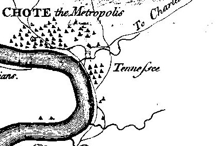
| Opis | Detail of Henry Timberlake's 1762 (published 1765) "Draught of the Cherokee Country" showing Tanasi. Timberlake's spelling of Tanasi as "Tennessee" is one of the first widely published uses of this spelling of the state's namesake. Tanasi declined after 1730 and by Timberlake's time had been overshadowed by neighboring Chota. The bend in the river is Bacon's Bend. |
| Data | |
| Źródło | Henry Timberlake, Memoirs (1765) |
| Autor | Henry Timberlake |
| Inne wersje |
|

Licencja
|
Ten materiał przeszedł do domeny publicznej w kraju pochodzenia, jak również w państwach i terytoriach, gdzie prawo autorskie wygasa w ciągu 100 lat po śmierci autora. | |
| Plik rozpoznano jako wolny od znanych ograniczeń praw autorskich, włącznie z prawami zależnymi i pokrewnymi. | |
Historia pliku
Kliknij na datę/czas, aby zobaczyć, jak plik wyglądał w tym czasie.
| Data i czas | Miniatura | Wymiary | Użytkownik | Opis | |
|---|---|---|---|---|---|
| aktualny | 00:09, 28 mar 2008 | | 434 × 286 (44 KB) | BrineStans | {{Information |Description=Detail of Henry Timberlake's 1762 (published 1765) "Draught of the Cherokee Country" showing Tanasi. Timberlake's spelling of Tanasi as "Tennessee" is one of the first widely published uses of this spelling of the state's names |
Lokalne wykorzystanie pliku
Poniższa strona korzysta z tego pliku:
Globalne wykorzystanie pliku
Ten plik jest wykorzystywany także w innych projektach wiki: