Plik:Verbreitung der Konfessionen im deutschen Reich.jpg

Rozmiar pierwotny (3160 × 2547 pikseli, rozmiar pliku: 6,69 MB, typ MIME: image/jpeg)
| Plik Verbreitung der Konfessionen im deutschen Reich.jpg znajduje się w Wikimedia Commons – repozytorium wolnych zasobów. Dane z jego strony opisu znajdują się poniżej. |
Opis
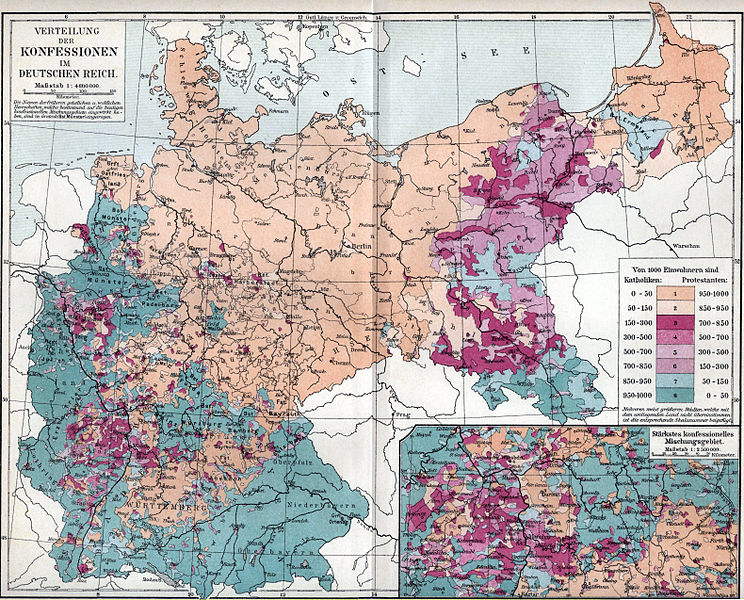
| Opis | Map showing distribution of Catholics and Protestants in the German Reich as of the 1890s. For a full discussion of this map, including detailed statistics, from the original source (and written in German), see the talk page. |
| Data | 1893–97 |
| Źródło | Map owned and scanned by Angr |
| Autor | Meyers Konversationslexikon, 5th edition |
| Licencja (Ponowne użycie tego pliku) |
Public domain |
Licencja
|
Ten materiał przeszedł do domeny publicznej w kraju pochodzenia, jak również w państwach i terytoriach, gdzie prawo autorskie wygasa w ciągu 70 lat po śmierci autora.
| |
| Plik rozpoznano jako wolny od znanych ograniczeń praw autorskich, włącznie z prawami zależnymi i pokrewnymi. | |
Historia pliku
Kliknij na datę/czas, aby zobaczyć, jak plik wyglądał w tym czasie.
| Data i czas | Miniatura | Wymiary | Użytkownik | Opis | |
|---|---|---|---|---|---|
| aktualny | 06:39, 7 lut 2014 | | 3160 × 2547 (6,69 MB) | DIREKTOR | Crop & tone |
| 08:49, 1 gru 2007 |  | 3512 × 2553 (1,43 MB) | Mahagaja | {{Information |Description=Map showing distribution of Catholics and Protestants in the German Reich as of the 1890s |Source=Map owned and scanned by Angr |Date=1893–97 |Author=Meyers Konversationslexikon, 5th edition |Permission=Public do |
Lokalne wykorzystanie pliku
Poniższa strona korzysta z tego pliku:
Globalne wykorzystanie pliku
Ten plik jest wykorzystywany także w innych projektach wiki:
- Wykorzystanie na ar.wikipedia.org
- Wykorzystanie na azb.wikipedia.org
- Wykorzystanie na da.wikipedia.org
- Wykorzystanie na de.wikipedia.org
- Wykorzystanie na el.wikipedia.org
- Wykorzystanie na en.wikipedia.org
- Wykorzystanie na fr.wikipedia.org
- Wykorzystanie na hr.wikipedia.org
- Wykorzystanie na it.wikipedia.org
- Wykorzystanie na ko.wikipedia.org
- Wykorzystanie na mt.wikipedia.org
- Wykorzystanie na pt.wikipedia.org
- Wykorzystanie na zh.wikipedia.org