Plik:VolgaDelta AMO 2005jun11.jpg

Rozmiar pierwotny (1115 × 1061 pikseli, rozmiar pliku: 276 KB, typ MIME: image/jpeg)
| Plik VolgaDelta AMO 2005jun11.jpg znajduje się w Wikimedia Commons – repozytorium wolnych zasobów. Dane z jego strony opisu znajdują się poniżej. |
Opis
| Opis |
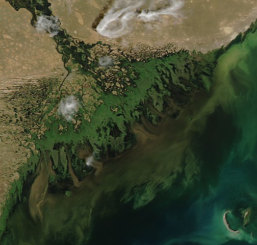
Satellite image of the w:Volga Delta at the w:Caspian Sea. This time of year, the river is running high, flushed with melting snow and springtime rain. The flood water has swept dark brown mud into the Caspian Sea. The mud fades to a soupy green as it becomes diluted in the water. While most of the green seen in the Caspian Sea in this image appears to be diluted mud, some may be phytoplankton or w:algal blooms, particularly in the lower right corner of the image. Satellite image of the w:Volga Delta at the w:Caspian Sea. The deep green braids of the Volga River fan into a broad delta on the northwest shore of the Caspian Sea. More than 500 channels flow from the river into the sea, creating a web of wetlands that supports hundreds of species of birds, fish, and plants. The Volga River delta is one of the most productive regions of the world for fish, particularly caviar-producing sturgeon, 25 percent of which live in the Volga River. The delta also contains oil deposits where millennia of carbon-rich mud have piled until pressure and heat converted the organic material in the lowest layers into petroleum. This photo-like image of the delta was taken by the Moderate Resolution Imaging Spectroradiometer (MODIS) on NASA’s Aqua satellite on June 11, 2005. This time of year, the river is running high, flushed with melting snow and springtime rain. The flood water has swept dark brown mud into the Caspian Sea. The mud fades to a soupy green as it becomes diluted in the water. Mud is not the only thing pouring into the sea with the river water. The Volga River is Europe’s longest river, flowing some 3,700 kilometers (2,300 miles) from its source in the Valday hills of northwest Russia to the Caspian Sea. As it winds its way through Russia, it passes through several large cities, and it is lined with agriculture. In its travels, the river picks up agricultural and industrial run-off, and these chemicals are deposited into the Caspian at the Volga River delta. The added fertilizers nourish the algal blooms that grow on the surface of the sea, allowing them to grow larger. When they die, the plants begin to sink and are consumed by bacteria. A thick layer of decaying plants can suck all of the oxygen out of the water, leaving pockets of oxygen-poor water where fish cannot survive. For this reason, large algal blooms can result in fish kills. While most of the green seen in the Caspian Sea in this image appears to be diluted mud, some may be phytoplankton or algal blooms, particularly in the lower right corner of the image. |
| Data | |
| Źródło | https://earthobservatory.nasa.gov/images/5650/volga-river-delta |
| Autor | Jeff Schmaltz, MODIS Land Rapid Response Team at NASA GSFC |
Licencja
| Ten plik jest w domenie publicznej ponieważ został stworzony przez NASA. Polityka praw autorskich NASA stwierdza, że „materiały NASA nie są chronione prawami autorskimi, chyba że zapisano inaczej”. (NASA copyright policy lub JPL Image Use Policy). | ||
 |
Uwaga:
|
Historia pliku
Kliknij na datę/czas, aby zobaczyć, jak plik wyglądał w tym czasie.
| Data i czas | Miniatura | Wymiary | Użytkownik | Opis | |
|---|---|---|---|---|---|
| aktualny | 12:58, 12 sie 2019 | | 1115 × 1061 (276 KB) | Ariadacapo | Crop back to original ratio (75 % horizontally, 81 % vertically using CropTool with lossless mode) |
| 12:55, 12 sie 2019 |  | 4400 × 5600 (5,32 MB) | Ariadacapo | Original from source | |
| 01:46, 9 maj 2006 |  | 540 × 540 (62 KB) | Holly Cheng | {{Information | Description=Satellite image of the w:Volga Delta at the w:Caspian Sea. This time of year, the river is running high, flushed with melting snow and springtime rain. The flood water has swept dark brown mud into the Caspian Sea. The |
Lokalne wykorzystanie pliku
Następujące strony korzystają z tego pliku:
Globalne wykorzystanie pliku
Ten plik jest wykorzystywany także w innych projektach wiki:
- Wykorzystanie na alt.wikipedia.org
- Wykorzystanie na ar.wikipedia.org
- Wykorzystanie na arz.wikipedia.org
- Wykorzystanie na az.wikipedia.org
- Wykorzystanie na ba.wikipedia.org
- Wykorzystanie na be.wikipedia.org
- Wykorzystanie na ce.wikipedia.org
- Wykorzystanie na ckb.wikipedia.org
- Wykorzystanie na de.wikipedia.org
- Wykorzystanie na de.wikivoyage.org
- Wykorzystanie na en.wikipedia.org
- Wykorzystanie na eo.wikipedia.org
- Wykorzystanie na es.wikipedia.org
- Wykorzystanie na fa.wikipedia.org
- Wykorzystanie na hy.wikipedia.org
- Wykorzystanie na id.wikipedia.org
- Wykorzystanie na ka.wikipedia.org
- Wykorzystanie na kk.wikipedia.org
- Wykorzystanie na nl.wikipedia.org
- Wykorzystanie na nn.wikipedia.org
- Wykorzystanie na no.wikipedia.org
- Wykorzystanie na ro.wikipedia.org
- Wykorzystanie na ru.wikipedia.org
- Wykorzystanie na si.wikipedia.org
- Wykorzystanie na sk.wikipedia.org
- Wykorzystanie na sl.wikipedia.org
- Wykorzystanie na tr.wikipedia.org
- Wykorzystanie na tt.wikipedia.org
- Wykorzystanie na uk.wikipedia.org
- Wykorzystanie na vi.wikipedia.org
- Wykorzystanie na www.wikidata.org
- Wykorzystanie na zh-yue.wikipedia.org