Plik:Expulsion map of the Circassians in 19th century.PNG
Grafika w wyższej rozdzielczości nie jest dostępna.
Expulsion_map_of_the_Circassians_in_19th_century.PNG (491 × 445 pikseli, rozmiar pliku: 15 KB, typ MIME: image/png)
| Plik Expulsion map of the Circassians in 19th century.PNG znajduje się w Wikimedia Commons – repozytorium wolnych zasobów. Dane z jego strony opisu znajdują się poniżej. |
Opis
| Opis |
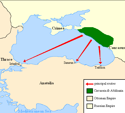
English: Map showing the location of Circassia and the expulsion routes (1859-1864) of the Circassians and other Caucasian peoples to the Ottoman Empire, after the Russian annexation of the North-Caucasus following the Crimean War of 1853-1856.
I used the information of the following two maps: http://www.circassianworld.com/CIRCASSIA1840.jpg And the books: The Northwest Caucasus: past, present, future, Walter Richmond The forgotten minorities of Eastern Europe, Arno TannerРусский: Карта с указанием местонахождения Черкесии и высылки маршрутов (1859-1864) от черкесов и других кавказских народов в состав Османской империи, после русской аннексии Северо-Кавказского следующие Крымской войны 1853-1856 гг. |
| Data | |
| Źródło | Praca własna |
| Autor | DragonTiger23 |
Licencja
| Ja, właściciel praw autorskich do tej pracy, udostępniam ją jako własność publiczną. Dotyczy to całego świata. W niektórych krajach może nie być to prawnie możliwe, jeśli tak, to: Zapewniam każdemu prawo do użycia tej pracy w dowolnym celu, bez żadnych ograniczeń, chyba że te ograniczenia są wymagane przez prawo. |
Historia pliku
Kliknij na datę/czas, aby zobaczyć, jak plik wyglądał w tym czasie.
| Data i czas | Miniatura | Wymiary | Użytkownik | Opis | |
|---|---|---|---|---|---|
| aktualny | 22:06, 5 lip 2013 | | 491 × 445 (15 KB) | Irānshahr | |
| 04:01, 4 lip 2013 |  | 491 × 445 (15 KB) | Irānshahr | Olahus is correct. | |
| 11:23, 3 lip 2013 |  | 491 × 445 (15 KB) | DragonTiger23 | Reverted to version as of 18:05, 11 February 2011 | |
| 15:23, 9 gru 2011 |  | 491 × 445 (15 KB) | Olahus | The Circassian inhabited region was actually much bigger. | |
| 20:05, 11 lut 2011 |  | 491 × 445 (15 KB) | DragonTiger23 | {{Information |Description ={{en|1=Map showing the location of Circassia and the expulsion routes (1859-1864) of the Circassians and other Caucasian peoples to the Ottoman Empire, after the Russian annexation of the North-Caucasus following the Crimean |
Lokalne wykorzystanie pliku
Poniższa strona korzysta z tego pliku:
Globalne wykorzystanie pliku
Ten plik jest wykorzystywany także w innych projektach wiki:
- Wykorzystanie na bg.wikipedia.org
- Wykorzystanie na ca.wikipedia.org
- Wykorzystanie na de.wikipedia.org
- Wykorzystanie na it.wikipedia.org
- Wykorzystanie na ja.wikipedia.org
- Wykorzystanie na lmo.wikipedia.org
- Wykorzystanie na nl.wikipedia.org
- Wykorzystanie na ru.wikipedia.org
- Wykorzystanie na ru.wikinews.org
- Wykorzystanie na sh.wikipedia.org
- Wykorzystanie na tr.wikipedia.org