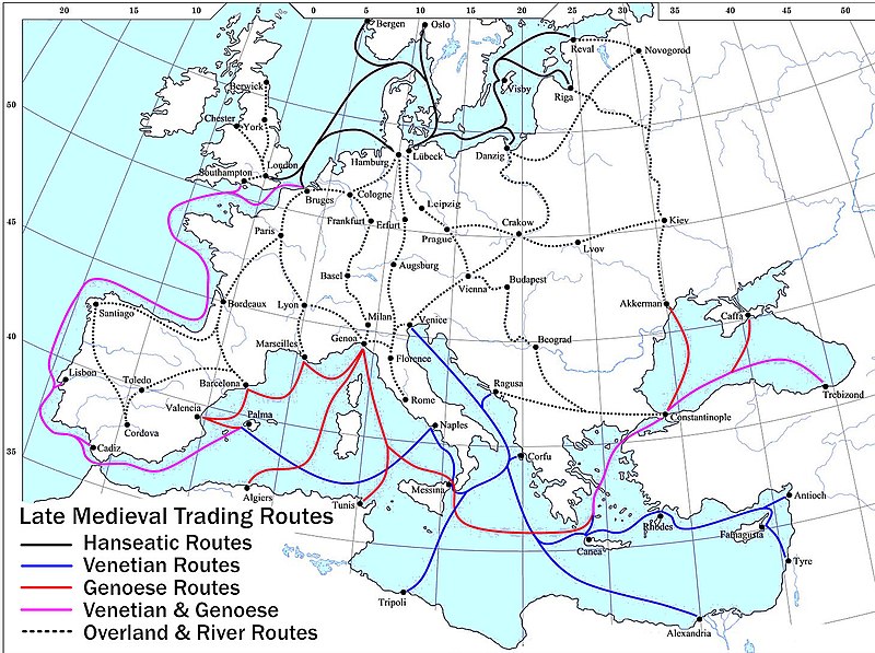
Plik:Late Medieval Trade Routes.jpg

Rozmiar podglądu – 800 × 597 pikseli. Inne rozdzielczości: 320 × 239 pikseli | 640 × 478 pikseli | 1024 × 765 pikseli | 1280 × 956 pikseli | 1457 × 1088 pikseli.
Rozmiar pierwotny (1457 × 1088 pikseli, rozmiar pliku: 372 KB, typ MIME: image/jpeg)
Historia pliku
Kliknij na datę/czas, aby zobaczyć, jak plik wyglądał w tym czasie.
| Data i czas | Miniatura | Wymiary | Użytkownik | Opis | |
|---|---|---|---|---|---|
| aktualny | 22:46, 18 maj 2022 |  | 1457 × 1088 (372 KB) | Richard2s | Clearer key for map |
| 22:25, 23 sty 2011 |  | 853 × 544 (453 KB) | Micsha~commonswiki | Includes map key on the map | |
| 17:55, 28 mar 2008 |  | 1817 × 1120 (487 KB) | Lampman | {{Information |Description=Map showing the main trade routes of late medieval Europe. The black lines show the routes of the Hanseatic League, the blue Venetian and the red Genoese routes. Purple lines are routes used by both the Venetians and the Genoese |
Lokalne wykorzystanie pliku
Następujące strony korzystają z tego pliku:
Globalne wykorzystanie pliku
Ten plik jest wykorzystywany także w innych projektach wiki:
- Wykorzystanie na ar.wikipedia.org
- Wykorzystanie na be-tarask.wikipedia.org
- Wykorzystanie na bg.wikipedia.org
- Wykorzystanie na ca.wikipedia.org
- Wykorzystanie na da.wikipedia.org
- Wykorzystanie na el.wikipedia.org
- Wykorzystanie na en.wikipedia.org
- Wykorzystanie na es.wikipedia.org
- Wykorzystanie na et.wikipedia.org
- Wykorzystanie na fr.wikipedia.org
- Wykorzystanie na he.wikipedia.org
- Wykorzystanie na hy.wikipedia.org
- Wykorzystanie na it.wikipedia.org
- Wykorzystanie na ja.wikipedia.org
- Wykorzystanie na mk.wikipedia.org
- Wykorzystanie na nl.wikipedia.org
- Wykorzystanie na pt.wikipedia.org
- Wykorzystanie na rm.wikipedia.org
- Wykorzystanie na sh.wikipedia.org
- Wykorzystanie na sl.wikipedia.org
- Wykorzystanie na sq.wikipedia.org
- Wykorzystanie na uk.wikipedia.org
- Wykorzystanie na vi.wikipedia.org
Pokaż listę globalnego wykorzystania tego pliku.

